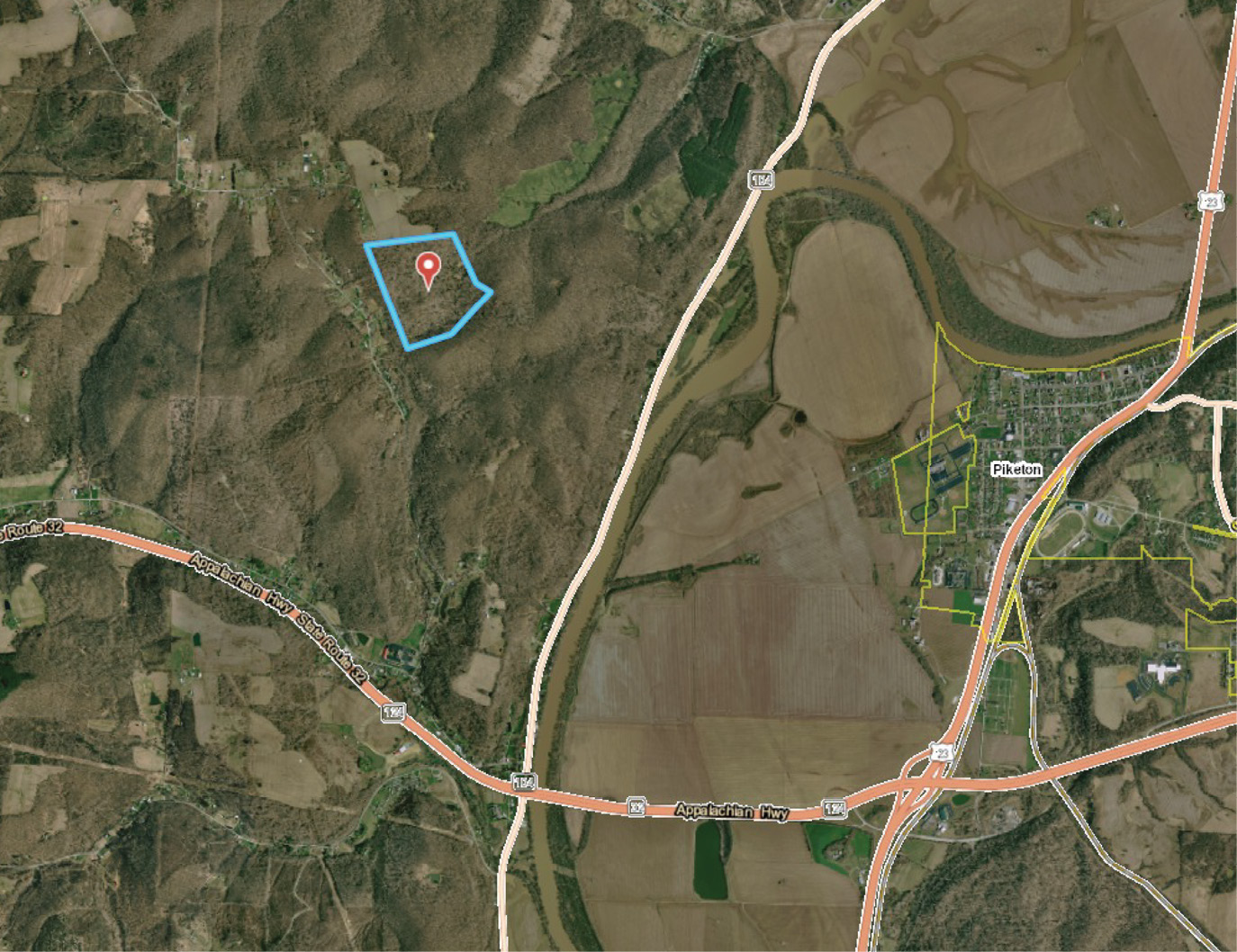
The subject parcel lays in the rolling hills of Ohio’s Virginia Military District. Early surveys date back to the late 1700’s and are anything but rectangular.
In the January 2020 installment of Decided Guidance we visited the First Seven Ranges of The USPLSS in Guernsey County, Ohio. We’re going back to Ohio to armchair some surveying in Virginia Military District of Pike County which is a strict two hour and 10 minute drive under the watchful eye of the Ohio State Highway Patrol and no doubt traverses the world renowned orange barrel forests. That segues neatly into today’s public service announcement. Slow the heck down in work zones. ‘Nuff said!
Barker v. McCoy (Court of Appeals of OHIO Fourth Appellate District PIKE COUNTY Case No. 14CA849) offers some thought provoking content for us non-lawyer folk. After the appellate court mostly upheld the lower court decision on September 11, 2015, a Memorandum in Support of Jurisdiction was filed with the Supreme Court of Ohio by the Appellant McCoy. The Argument was “It is plain error for a court to consider a survey in a quiet title action when the surveyor failed to follow the established standards for performing boundary line surveys.” On January 20th 2016 Chief Justice O’connor responded “Upon consideration of the jurisdictional memoranda filed in this case, the court declines to accept jurisdiction of this appeal…”. So the monkey died and the show is over. The land surveying standards adopted by the Ohio Legislature don’t matter because the Supreme Court said so. If you believe that last part please check my Zillow listing for Y Bridge in Zanesville. I’m letting it go for a song.
The Supreme Court tossed this appeal apparently because the time to beat up a survey is at the trial. The lower Appellate Court called it out as follows, “…McCoys argue that the survey should not have been admitted into evidence, they forfeited this argument because they offered no objection to it at trial.” The Supreme Court seemed to agree de jure.
I looked at the recorded survey by Crabtree. It’s a little bit sparse compared to a competitor’s recorded survey of the same subject in the same era. However, it also appears functional for its purpose. It’s sealed, it contains relevant info, and it looks not unlike many surveys I have retraced. I won’t, nay can’t tell you if it is 100% compliant with the laws and standards of the Buckeye State. I’m simply not intimate with the local practices so I’ll just leave it at “it looks functional”.
I suspect that’s how judges, lawyers, and the rest of the world view our work. Maps are sealed, we are competent, and our opinions are conclusive. Given that notion I believe the public has a right to presume that standards are met when our seal is applied. Otherwise, what’s the point, right?
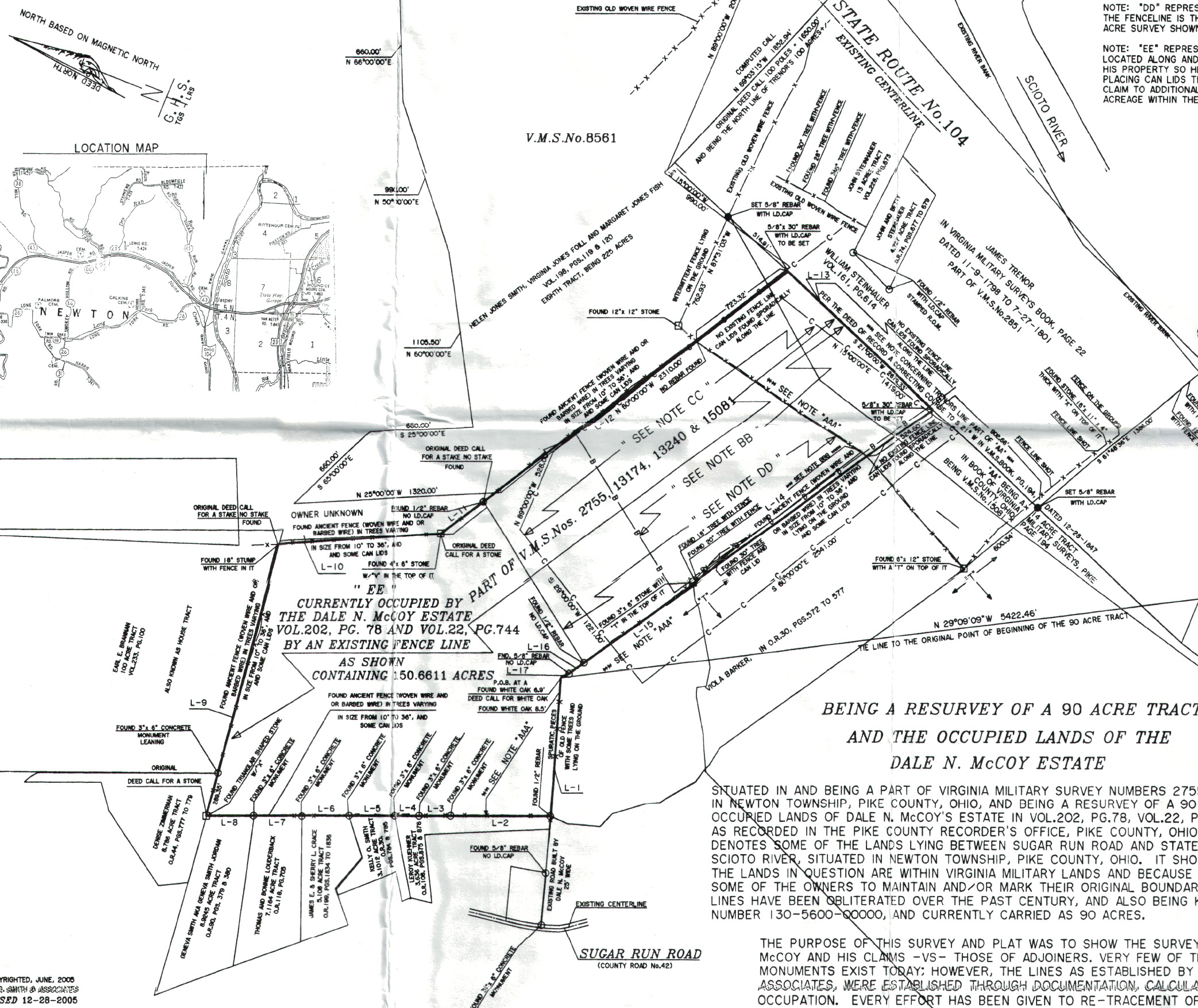
T.G. Smith conducted a spectacular retracement of original Virginia Military Surveys, deeds, and possession. His map clearly illustrates the complex nature of retracement outside of the PLSS.
The aforementioned “competitor’s survey” was performed in 2003 and completed in 2005 by T.G. Smith. This is after and perhaps in conjunction with the original complaint filed on April 2, 2002, but I can’t quite say for sure.
Smith put together a real masterpiece of a retracement survey. Smith went back at least to 1798 and tied in the Scioto River, trees, ancient fences, various stones, blazed trees, tin can lids hung as shiners and a historic bridge abutment. Plenty of research was included and noted on the map as well. It’s clear that Smith had the benefit of hindsight given the timing and his references to Crabtree’s survey. Regardless, this is a thorough piece of work and how we should approach every retracement. That is, like it’s going to court.
The facts in the appellate decision say “The Barkers testified that they were considering selling their entire holdings and had the property surveyed. Dale and Robert McCoy believed that 50 acres belonged to them and disagreed with the Barkers’ survey.” Barker’s survey was done by Crabtree and became the subject survey of this case.
So we have two good surveys that both tie deeds down with occupation. Is there a tie-breaker here? The court said “Because Crabtree’s survey was admissible, the trial court properly relied on it to determine the McCoys owned the 50 acres by virtue of their deed.” Okay, so Crabtree convinced the court that he faithfully retraced Barker’s deed on the ground. Maybe a better way to say it is the court had no reason not to accept the evidence at face value. A duly licensed Surveyor submitted a sealed opinion to the parties. One of the parties disagreed with the Crabtree opinion but both apparently we’re okay with it being accepted into evidence.
Interestingly, the decision is silent with reference to Smith’s survey. Now this is where I get confused. It’s plain to see that Smith’s opinion fits the local records and McCoy’s long standing occupation. It doesn’t appear as a fluke or bias either. It’s a well constructed opinion built on a collection of evidence and clearly spelled out in his narrative. I can’t tell you if both surveyors had all of the same evidence. What I can say is that Smith definitely showed more cards.
So here’s my tally from each survey found on the Pike County Engineer’s GIS. Crabtree shows 3 stones found, 3 ( ⅝”x 30″) rebar set, 2 white oak trees found, 1 symbolized fence line along boundaries, 1 stake, 14 linear dimensions, 2.5 (yep, he gets a half credit) record deed references, 3 record surveys, and a few speckled notes amounting to 58 words that I’ll optimistically call a narrative.
In contrast Smith shows 6 stones found, 4 (⅝” x 30″) rebar set, 7 various rebar found, 3 white oak trees, no less that 20 calls for specific line trees, blazed timbers, and corner stumps found, 16 calls for fence line, or fence remnants, and tin can lids dispersed among fence, 7 concrete monuments found, 1 bridge abutment, 1 point on the river bank, no less than 43 linear measurements, 15 record deed references, 6 surveys, and a loosely counted 780 words of narrative that I’ll round up to 800 including small notes on the drawing. Again, I don’t really know if Crabtree had the same information as Smith but I sure as hell know he was bashful about reporting it on his survey. Just for reference my typical Thought Leader Editorial contains about 600 words.
If there’s any lawyer folk reading this please pay attention. GET A SECOND OPINION before you litigate! According to a 2011 article on the Harvard Health website https://www.health.harvard.edu/newsletter_article/a-matter-of-opinion. Dr. Gregory Abel says, “If you have a doctor who would be offended by a second opinion, he or she is probably not the right doctor for you.” More directly with rope stretching, if a surveyor is offended by a second opinion from another, then chances are one of them is missing critical evidence. Leveling the playing field with equal evidence may iron out a wrinkled opinion before litigation.
In this case T.G. Smith may have had some evidence that Crabtree was not privy to. Smith corroborated a deed call for an adjoiner with an existing occupation line of an adjoining ancient survey, the natural boundary of the Scioto River, and a call for a historic bridge abutment which he recovered. This extensive recovery work to the east is not apparent on Crabtree’s west-centric survey. As Smith points out this evidence makes a significant difference in the physical retracement of the boundaries.
What do we learn from Barker v. McCoy? Well for starters the parties can accept or stipulate to evidence they wish to discuss. We’ve seen this before. Back in October 2017 we looked at Bryant v. Blevins (Superior Court of Sacramento County, CA. No. CV512339). The parties stipulated to using only one survey. Right, wrong or just bat-wing crazy against the codified standards the parties agreed it was sufficient. This leads me to a parallel notion. Discovery might just be the ultimate “garbage in garbage out” exercise. So if the court faces poor or lackluster evidence why couldn’t it arrive at some poor or lackluster conclusion? That might explain a few of those head scratcher decisions we hear about every now ‘n again.
Think about this the next time you read a decision. Did that court have the benefit of your wisdom and expertise in their evidence? Did the subject surveys reveal conclusive evidence? Was parol evidence needed to supplement the subject surveys? Most importantly what evidence did the court admit? Now ask and answer those same questions in future tense before you seal your next survey.
I want to jump back to the appeal. Does this decision mean that minimum standards are worthless and can be disregarded? I don’t think so. It seems like a court is going to accept anything it can to get to the bottom of an issue. I have a sneaking suspicion that non-compliance with standards might not have been raised until after discovery was closed. That might explain why the court did not upset the apple cart.
When a survey does not represent the written, physical, and parol evidence there is a problem. Set aside minor reporting errors like typos and occasional flubs from copy/paste commands. Those ticky-tackies should be easily smoked out and accepted as stuff that just happens. Heck, I’d even give our peers some latitude on a missing north arrow or basis of bearings statement. However, Comparing these two surveys reveals a material difference in the written, physical, and parol evidence considered in each. I suspect this motivated McCoy to appeal the trial court’s decision. The appeal says “The McCoys assert that the trial court erred when it quieted title to the disputed property to the Barkers. The McCoys argue that because the Barkers’ surveyor failed to follow the applicable standards for determining property boundaries, the trial court erred as a matter of law in considering the survey. The McCoys argue that without the survey the trial court’s decision is against the manifest weight of the evidence. To the extent the McCoys argue that the survey should not have been admitted into evidence, they forfeited this argument because they offered no objection to it at trial.
And based on the survey there is substantial competent, credible evidence that the Barkers owned the 50 acres by virtue of their deed. Accordingly, we overrule the McCoys’ first assignment of error.”
The court summed it up and resolved any non-compliance issues with Crabtree’s Survey. Whether or not he met every standard was subordinate to the court’s conclusion that Crabtree’s retracement was substantially competent, credible evidence.