Enabling Beyond Visual Line of Sight (BVLOS) Operations for UAS in GNSS-Denied Environments
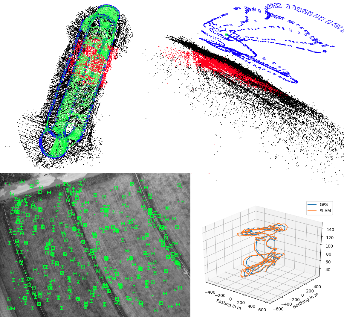
A preliminary comparison of GPS vs simultaneous localization and mapping (SLAM) from video flight data, this will be augmented with additional corrections using radio source localization for the final product. Upper left: the flight path (blue) current scene keypoints (red) and previous keypoints (green). Upper Right: the same scene but with video frame locations along the flight path. Lower Left: Keypoints calculated from a single downward looking frame. Lower Right: The comparison of GPS derived location vs SLAM derived location, showing at most a 10 meter error over a kilometer long track.
Boulder, CO – (January 18, 2021) – With nearly 95,000 miles of domestic coastline, NOAA’s National Geodetic Survey faces a daunting task. Under current FAA regulations, unmanned aircraft system (UAS) operators are required to keep their aircraft within visual line of sight, making coastline surveys time-consuming and arduous, having to tediously map 2-mile segments at a time, and then relocate to the next operating area. To address this challenge NOAA has selected Black Swift Technologies (BST) to develop commercially viable technology enabling GPS-denied navigation of UAS—technology critical in enabling long distance, beyond visual line of sight (BVLOS) flights.
“Enabling BVLOS operations in the National Airspace System is largely an issue of improved sensing,” states Jack Elston, Ph.D., CEO of Black Swift Technologies. “Operators, both government and commercial, are looking to perform missions over longer distances. These users represent a number of currently under-utilized applications for UAS due to capability and regulations—applications such as aerial imaging, environmental observation, precision agriculture, and infrastructure monitoring and inspection.”
Accurate aircraft position information is essential for safe UAS operations within the Unmanned Aircraft Systems Traffic Management (UTM) system. Unfortunately, the primary system that provides position information, GPS, is a single point of failure in the system, subject to jamming and spoofing, along with on-board failure or poor signal quality in locations such as urban canyons, at high latitudes or high altitudes.
BST aims to provide a robust, secondary navigation option through their diverse-source global positioning system (DS-GPS) that will provide accurate position updates to UAS in GPS denied areas through augmented sensor suites and advanced machine learning capabilities. This will be performed through the careful weighted fusion of advanced machine vision algorithms with the localization of the vehicle using triangulated signals of opportunity—essentially everything emitted within a set of frequencies from a non-moving source.
How it Works
DS-GPS utilizes a standard GPS receiver augmented through the use of additional sensing capabilities to estimate inertial velocity and absolute position. This information allows for the vehicle to determine when the GPS signal is degraded either through spoofing or environmental effects. Other sensors, including cameras and a software-defined-radio, can then be used to replace the GPS as the primary navigational sensor providing position and velocity estimates from diverse sources.
“Black Swift Technologies has worked with NOAA in particular in the past to supply systems that can be used for both coastline work and atmospheric science,” Elston emphasizes. “The work in this SBIR is a natural extension of the machine learning based techniques BST has been developing for unmanned aircraft. One of the key technologies of this work is to use machine vision (both optical flow and SLAM) to allow continued safe flight of UAS in the event of loss of GPS. Work associated with coastline inspection and mapping would greatly benefit from BVLOS operations since this would significantly reduce the amount of time an operator has to spend in the field.”
About Black Swift Technologies
Founded in 2011, Black Swift Technologies LLC, is recognized for delivering reliable, robust, and highly accurate unmanned aircraft systems capable of flying scientific payloads in demanding atmospheric environments (high-altitude, arctic, desert, corrosive particulates, and strong turbulence). Its purpose-built scientific aerial platforms are used around the globe for a variety of specialized atmospheric research missions in extreme conditions, including monitoring and assessing wildland fires, volcanoes, tornadoes, and hurricanes.
All BST’s UAS solutions leverage the Company’s advanced SwiftCore™ Flight Management System (FMS) consisting of the SwiftPilot™ autopilot system, the SwiftTab™ tablet-based user interface, the SwiftStation™ ground station, and application specific sensor integrations. The SwiftCore FMS is modular, robust, and simple to operate allowing users to focus on data products. SwiftCore FMS has been approved and used for major scientific missions by NASA, deployments by NOAA, and by a growing list of commercial users including engineering and survey professionals, construction and mining managers, as well as environmental monitoring by scientific and academic organizations worldwide.
In addition to the SwiftCore FMS, Black Swift Technologies has unique capabilities to develop and deploy advanced small unmanned aircraft systems due the team’s combined expertise in the design, implementation, and analysis of advanced “smart” control systems, expertise in legal and safe flight operations in the United States airspace, and their practical experience and knowledge from thousands of hours of UAS flight operations in demanding conditions. The SwiftCore FMS enables advanced control systems. These “smart” control systems provide industry leading sensor-based control of the UAS that minimizes operator workload while improving the quality of the observed data by autonomously modifying the flight path based on sensor inputs.
More information on Black Swift Technologies and their suite of UAS solutions can be found at: bst.aero
