 The 1952 Louisiana Supreme Court case of Hill v. Richey (59 So. 2d 434 221 La. 402) reinforces some elementary concepts but also offers us a few new things to knit pick at. Ultimately this case is now just a ghost on the battlefield. The resulting line resolved by the court became irrelevant when the private land rights were later merged and erased under a blanket of some public taking. Unrelated to our focus it appears that CLECO Power subsequently acquired the land and created Lake Rodemacher for a cooling water reservoir. The lake is locally known as CLECO Lake and offers some great warm water bass fishing.
This case was born out of a third-party wraparound deal involving the sale of timber. In a nutshell the adjoining neighbors had no dispute and treated a historic line as the boundary for nearly half a century. The defendant offered his timber for sale and the logging company thought it was duly diligent in having the property surveyed before cutting the timber. The conflict materialized when the legally described property lines missed the accepted lines by a tune of about 85 acres. If we tally damages in 2020 dollars the record retracement led to trespass and an unauthorized harvest amounting to $60K worth of timber.
As typical the court builds its chain of title to the common grantor. That appears to take us back to 1898 for a senior tract and 1910 for a junior tract. I’m not sure if Jr./Sr. rights came into play here but I always try to make a marginal entry in my notes calling out the relationship. The court focused on both parties’ longevity in title and noted a few mesne conveyances following the original grants. I’ve said this before and believe that knowing the duration of title is an important aspect of retracement surveying. I’m not sure if there’s a “legal” basis propping up the notion but longevity sure as hell incubated the heap of parol evidence we see in this case. I also recall old Joe Arnold testifying to the Oregon Court about his family land from childhood. This is our Stop, Drop and Roll right here folks. Find out what the owners know so that you can help them sort out discrepancies before you finalize your opinion!
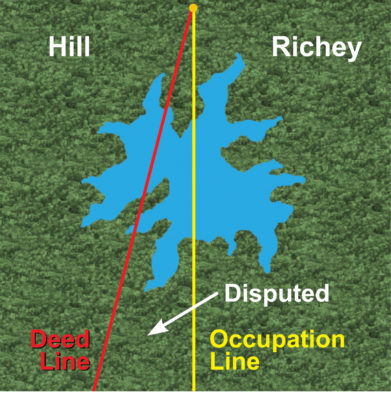
Okay, the court identified the conflict by a “red line” reflecting the deed calls and a “yellow line” expressing the possession line observed by both the plaintiff and defendant as long-term adjoining landowners. It seems like the court is comparing two equally weighted items doesn’t it? We’re talking about a record line vs. possession line so apples to apples, right? Well, in this case we might say the red line was just a stock photo of an apple marked “exhibit” and the yellow line was a big basketful of juicy ripe Fujis, Honeycrisps, Ambrosias, and probably an iPhone too. Sometimes placing a record line in the left basket of the scale can outweigh a mere claim of possession in the right basket. It’s not until testimony is added on the right side that the hollow weight of “record” becomes apparent. This case might be a bit atypical in that the testimony regarding the possession line is clear and overwhelming.
Let’s run the totals on evidence starting with the yellow line.
- The defendant told the timber surveyor that he only owned up to the yellow line.
- The defendant filed a suit against the timber folks indicating he did not know he owned the land.
- The yellow line is composed of blazed timber, fence lines and fence remnants.
- The 76-year-old plaintiff testified that a fence marked the yellow line since he was 10 years old.
- The current fence on the yellow line was built some 15 plus years prior and continually maintained by the plaintiff.
- The defendant built portions of fence along the yellow line.
- Fence was present thirty years prior when the defendant’s father purchased the property.
- Both plaintiff and defendant terminated cross fences at the yellow line.
- Both the plaintiff and defendant posted no trespassing signs in their names on blazed timber in the swampy portions along the yellow line.
- The blazes were understood to mean that the yellow line was surveyed at some time in history.
- The plaintiff showed 35 years of continual and uninterrupted use.
And now the tally on the redline.
- It is presumably a record description.
- This is the first time in known history that anybody is hearing of an alternate position of the line.
So, there we have it. The yellow line has eleven attributes, and the red line has two. Things are not feeling so even-steven, now are they? Who knows, maybe the timber company was willing to roll the dice and hold the red line based on some loss/profit analysis? I’m willing to bet the third-party employer opted for the most advantageous opinion their money could buy. Regardless we have a case of a surveyor ignoring salient evidence of a boundary. For god’s sake the owner himself flat out rejected the surveyor’s bonus acreage promised by this surveying bonanza.
The court goes through some legal questions about time and quality of possession. They traveled back 100 years and found a precedent interpreting Louisiana’s possession laws in Article 49. The court humbly offers that it had to do a little bit of homework on the topic of possession. After the citation from Ellis v. Prevost, 19 La. 251 the court said “Now, we understand the expressions, real and actual possession, contained in this law, as used in contra-distinction with the possession which is purely civil and legal…”. That small statement speaks volumes about the dignity of a court. There’s no pretense that the reviewing court is a subject matter expert in boundaries. However, this is the end of the line and the high court was going to do as much research as it took to resolve the matter.
Another term that came into play with possession was “enclosures”. This is a bit long-winded, but it exemplifies the reasonability of law. The court said “We recognize also that under the jurisprudence a person claiming by possession alone and without title is required to show an adverse possession by enclosures, and that his claim will not extend beyond such enclosures. But, when this jurisprudence is considered with the articles of the Code announcing the law applicable to such cases, we do not think that a strict interpretation should be given to the word “enclosures”…What the court means by “enclosures”, as that term is used in the numerous cases found in the jurisprudence, is that the land actually, physically, and corporeally possessed by one as owner must be established with certainty, whether by natural or by artificial marks; that is, that they must be sufficient to give definite notice to the public and all the world of the character and extent of the possession, to identify fully the property possessed, and to fix with certainty the boundaries or limits thereof. To say that the term means “enclosed only by a fence or wall” would be giving it a very strict and narrow construction, not justified or supported by the articles of the Code, as we have hereinabove pointed out, and would lead to absurd consequences in some cases.”
A definition of “boundary” was cited as well. “Further, Article 826 provides: “By boundary is understood, in general, every separation, natural or artificial, which marks the confines or line of division of two contiguous estates. Trees or hedges may
be planted, ditches may be dug, walls or enclosures may be erected, to serve as boundaries…But we most usually understand by boundaries, stones or pieces of wood inserted in the earth on the confines of two estates.” I believe that’s the best definition of a boundary that I’ve ever seen in print. Now keep in mind I’m relating two separated statements in the decision. Despite the stretch they simply go together like beans and cornbread.
Possession was important in this case and we as surveyors fundamentally need to identify evidence of possession. This court lays it out quite eloquently citing McHugh v. Albert Hanson Lbr. Co., Ltd., 129 La. 680, 56 So. 636 “What constitutes possession in any case is a question of fact, and each case depends upon its own facts.” That’s as elementary as it gets. It’s also the reason that a definition of possession is not psychometrically suited for a multiple-choice test question format.
The time elements of possession are extremely difficult for us to understand or convey in our survey and are generally revealed in the courtroom through testimony and perhaps other evidence. I can’t imagine how I would effectively express the following conditions in my survey “In the instant case plaintiff has established and proved beyond all question that he had actually, physically, and corporeally possessed as owner the property between the two lines, and, within the meaning of Article 49 of the Code of Practice as interpreted by this court, his possession continued to the moment of the disturbance.” That’s far beyond the scope of retracement surveying. Think about that as you try to self-adjudicate possession through cunning notes or narratives on your survey. I’ve seen too many failed attempts at that stunt down at the State Board Office.
There are some good physical features from this evidence pool that could, maybe should be prominently called out in a survey. “ The fences, remains of old fences, blazes and hacks on the trees evidently made by a surveyor, and the “No Trespassing” signs were sufficient under the facts of this case to establish with certainty and to give definite notice…” I’m breaking the quote here to make a point. That’s a good handful of evidence and in fact amounted to “definite” notice of the line. Ironically, a so-called expert surveyor hacking for a hungry timber outfit didn’t get the memo beforehand. The Court carries on with the statement and it gets better “…and to give definite notice to the public and all the world of the character and extent of his possession, to identify fully the property possessed, and to fix with certainty the boundaries or limits thereof, especially when we consider the type of land between the lines and the nature of the property.” I guess the conflicting deed doesn’t seem so strong in hindsight.
My hero in this case is Richey. He took a play right out of the King James Bible and held to the truth.
Citing Deuteronomy 19:14 “Thou shalt not remove thy neighbor’s landmark, which they of old time have set in thine inheritance, which thou shalt inherit in the land that the LORD thy God giveth thee to possess it.” Now I didn’t shepardize that citation through the old Luc-o-meter but any preacher man worth his salt will tell you this is good advice. Heck, Richey even packed this ethos along with him into court sans the hallowed citation.
The real question for the retracement surveyor is not the adjudication of this case, or its authority. It’s learning how to improve our discovery methods and deliver complete evidence if and when the court needs it. I contend that’s the best shot we have at keeping folks out of court.