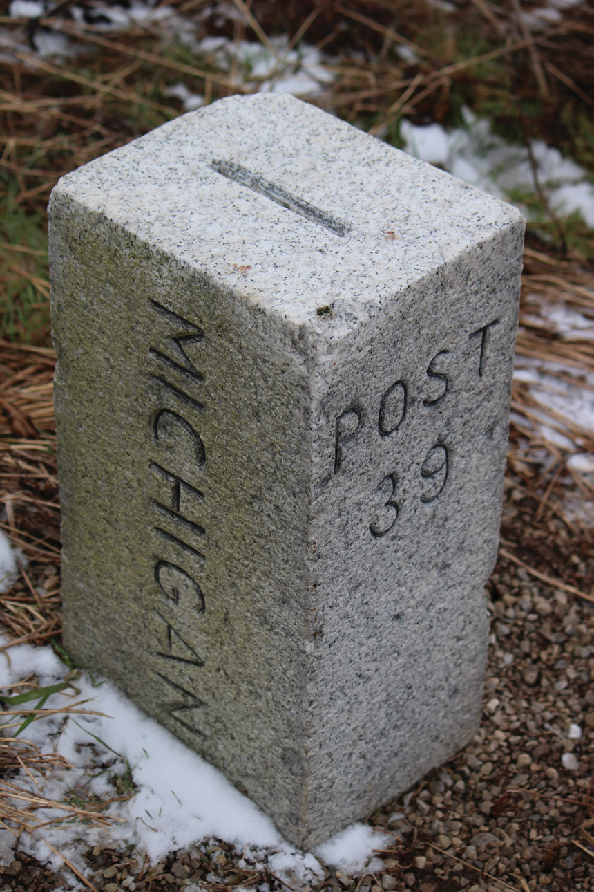
Michigan-Ohio Post 39
The State line between Michigan and Ohio was created, on paper, with the signing of the Northwest Ordinance of 1787. The Ordinance stated that “… they shall have authority to form one or two states in that part of the said territory which lies north of an east and west line drawn through the southerly bend or extreme of lake Michigan”1. Similar to the Melish Map that was used for the line between Texas and Oklahoma, little did the authors know that the map of which the Ordinance was drawn was grossly inaccurate2. John Mitchell artistically drew what is today called the Mitchell Map for the Earl of Halifax. Mitchell was a physician and a botanist, but far from a cartographer. The map, to Mitchell’s defense, was never meant to be used in the Northwest Ordinance, not to mention the 1763 Treaty of Paris. Consequently it was though and it became known as the “The most important map in U.S. History”3.
During the Ohio Constitutional Convention of 1802 a fur trapper mentioned that the Mitchell Map was geographically wrong. According to the Mitchell Map, a line drawn due East from the Southerly extreme of Lake Michigan would clearly put the mouth of the Maumee River into Ohio. However in the real world this line was approximately five miles to the South placing the growing port City of Toledo and the future terminus of the Miami and Erie Canal into the Territory of Michigan. The following year Ohio modified their Constitution, adding Section 6 to Article VII, and changed their North border to include Maumee Bay. According to Section 6, Ohio’s North line was described as “… a direct line running from the southern extremity of Lake Michigan to the most northerly cape of the Miami (Maumee) Bay”4.
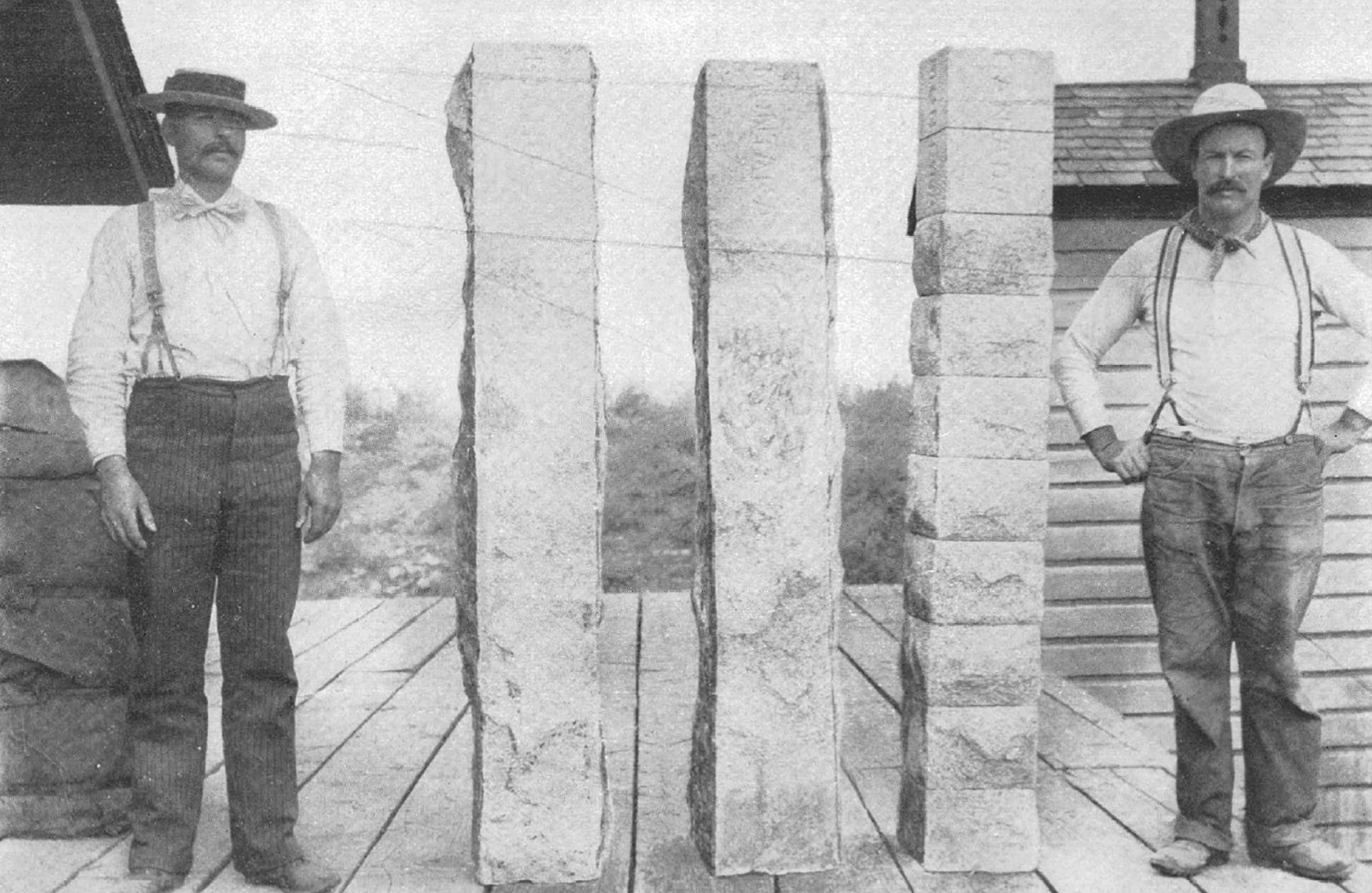
Granite Boundary Line Monuments. Plate VII of USGS Bulletin No. 170
The Michigan Territory was created by Congress in 1805 and clearly used the line as stipulated in the Northwest Ordinance of 1787. Due to a delay because of the War of 1812 an actual on the ground survey was not completed until 1817. Edward Tiffin, the U.S. Surveyor General, and former Ohio Governor, issued a contact to Deputy Surveyor William Harris to survey the line as described in Section 6. A year later Michigan declared the need for a survey of which was completed by Deputy Surveyor John A. Fulton. Once these surveys were completed the disputed territory was clearly marked on the ground comprising approximately 468 square miles called the “Toledo Strip”. To further confuse the situation, and to flip flop on his previous position, Tiffin ordered the General Land Office (GLO) deputy surveyors to terminate their surveys at the John A. Fulton Line which was one and the same as the 1787 Northwest Ordinance Line. The Ohio surveyors were traversing North and East from Ohio’s First Principal Meridian and Baseline while the Michigan surveyors were traversing South and East from the Michigan Meridian and Baseline. After the enforcement of the Pains and Penalties Act by the Michigan Territory the bloodless Toledo War broke out in 1835. Michigan petitioned for Statehood the same year but they were denied because of the boundary dispute with Ohio.
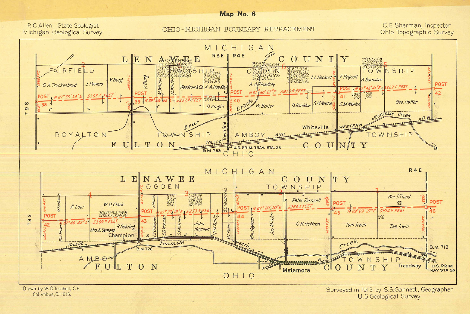
Map No. 6 Ohio-Michigan Boundary Retracement. Ohio-Michigan Boundary, Volume 1 of the Final Report.
In 1836 the Michigan Territory gave up the “Toledo Strip” and received the large majority of the Upper Peninsula and Michigan became the 26th State on January 26, 1837. The dispute with Ohio was far from over though. The State line continued to be one of confusion and frustration and wasn’t fully settled until 1915 when the two States agreed to have it surveyed, marked and recorded once and for all. This latest survey, jointly payed for by both States, was done between the months of July and October of 1915 by none other than the State Line Boundary Retracement Specialist, Samuel Stinson Gannett. Once again Sam put an end to likely the most highly disputed State line in U.S. history.
Since the Michigan and Ohio State Line was accepted as the 1817 Harris Survey it was necessary to tie together the confusion Tiffin made by terminating the GLO surveys to the 1818 Fulton Line. To remedy the situation GLO Deputy Surveyor Andrew Porter was awarded a contract to re-survey the State Line and make ties to the Section Corners in 1837. However, as time passed, the wooden posts stuck in the mud disappeared and it was apparent a new survey was needed. The 48th Legislature of Michigan passed Act 84 of the Public Acts of 1915 providing for “a joint re-location and permanent monumenting of the line between Ohio and Michigan”. This has been recorded under Joint Resolution 6 of 1917 with the Michigan Legislature. The 81st General Assembly of Ohio passed the same under House Bill 701 on May 27th, 19155. Once the paperwork and politics were complete the actual fieldwork could begin.
 The director of the USGS, Dr. George Otis Smith, appointed Samuel Stinson Gannett with this survey. Fortunately he wasn’t assigned to the heated dispute in the Smoky Mountains between Tennessee and North Carolina as this survey was assigned to others by the U.S. Supreme Court. Typically this would have been Sam’s wheelhouse, especially since he retraced this line in 1910 and was well aware of the conflict going on, but he couldn’t be two places at once. The first meeting concerning the Michigan and Ohio State Line wasn’t until July 7th in Toledo, Ohio where they executed a plan for the survey. The actual fieldwork started just a few days later on the 13th and the entire survey was completed on October 26th of the same year6. The survey crew started at the Northwest corner of the State as there was a reliable monument there to start from. Nothing existed on the Eastern end so it was determined to work from West to East. Since almost all of the original monuments from the 1817 and 1837 surveys were gone it was jointly decided by representatives from Michigan and Ohio, at a meeting on July 15th in Pioneer, Ohio, to accept “…existing monuments, fences, highways or other marks, when agreed to by land owners on both sides as being on the State line”. This method was meant to place the State line as close to the position as it was “originally staked out on the ground, and not necessarily run as a straight line…” The line was literally traversed on the ground with a 300 foot steel chain and a transit on loan from the USGS. Gannett took six astronomical observations to Polaris at sundown at eleven different positions along the line. The time for these observations was taken from the Union Telegraph Company in Toledo, which was tied to the U.S. Naval Observatory in Washington by telegraph lines.
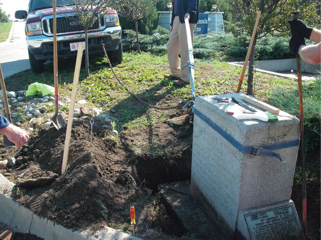
Post 70 in Lost Peninsula was the shining star of the 1915 Survey. In October of 2011 the Post was hit by a drunk lady in a Red Corvette. The monument held strong, but it did shift about four tenths out of alignment. A crew was mobilized to repair the monument, but this was no easy task. Post 70, also known as the Governor’s Monument, was not like the others; it was a behemoth. A 2500-pound behemoth measuring 48 x 30 x 18 inches. Fortunately, we had solid geometric reference swing ties and a first order position in the NGS database under PID MC1716. After “adjusting” the monument with the survey truck and filling the new voids with concrete Post 70 was once again in the position it has held since 1915. Everything was perfect once again for Post 70. Well not exactly as if you look close you can see that carved in solid granite a simple typo exists as the last name of one of the finest surveyors in the Country was spelt wrong.
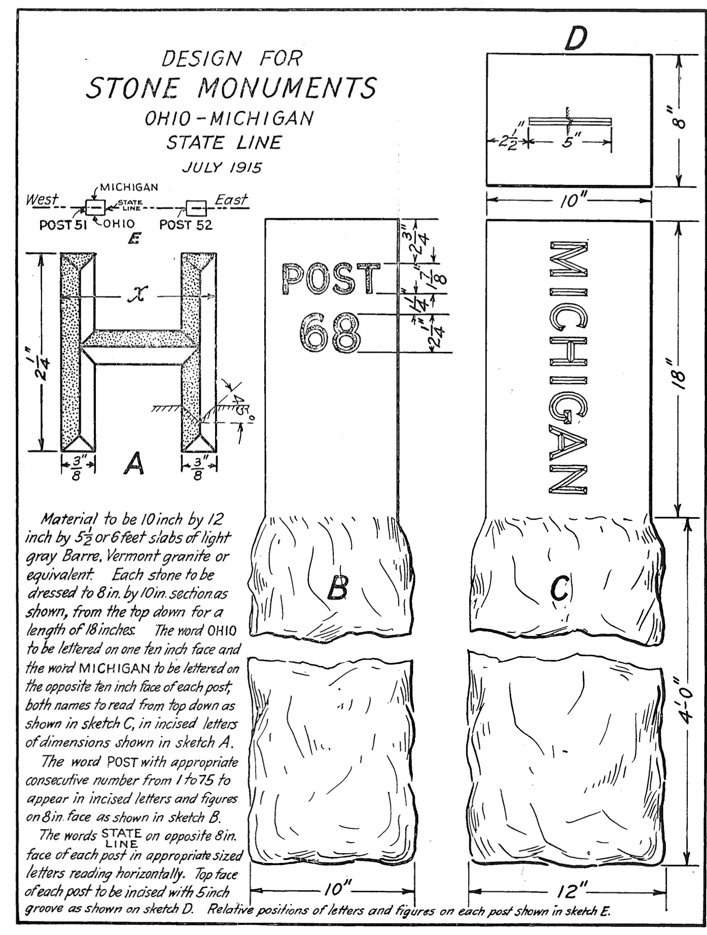
The monuments are a mirror image to the ones set along the Idaho/Montana and Idaho/Washington State Lines in 1896 and 1908 respectively7,8. Bearing an uncanny resemblance the only difference is the engraving and the quarry of origin. The western monuments came from Medical Lake, Washington while the Michigan/Ohio ones came from Mount Airy, North Carolina. The latter quarry, opened in 1743, is the “World’s Largest Open-Faced Quarry”9. The monuments were purchased and delivered in 1915 for $18.00 apiece. The monuments were a light gray granite post 5 ½ feet long and 12 inches square. The top 18 inches were dressed and cut to 8 by 10 inches. Once delivered the granite monuments were carved by Lloyd Brothers in Toledo, Ohio. The Lloyd Brothers were literally the three sons of Edward Lloyd whose Toledo business listing can be traced back to 1858. There were four invoices from Lloyd Brothers between August 20th and October 19th, 1915 totaling $1523.30 which included the monuments and the carving. The same granite, from the same quarry, can be found today, and sold by the North Carolina Granite Corporation under the registered trademark color White Mount Airy Granite10. Furthermore the granite boundary monuments, as set in 1915, can be found today. Travel along any backroad between Indiana and Lake Erie and one will find a Gannett monument almost every mile off the side of the road. Unfortunately a few have been destroyed and vandalized, but most of them still exist and hold, modern, high precision coordinate values with the National Geodetic Survey. Of course locally they control the division line between Michigan and Ohio.
After the survey fieldwork was complete the plats were drawn, notes were transcribed and bills were paid. The total expense for the survey, including the price of the monuments, was $7,197.98, of which over $2500 went to Gannett. Each state paid exactly $3600.00 towards the final product. Upon completion a ceremony was held on November 24th, 1915. Michigan Governor Woodbridge Nathan Ferris and Ohio Governor Frank Bartlett Willis, amongst other dignitaries, shook hands over Post 70 in Lost Peninsula to formalize the completion of the survey. The total length of the survey was 69.92 miles and due to the speed and efficiency of Gannett it was ranked as “…one of the least expensive boundary relocations ever made…” After resolving Michigan and Ohio, Gannett went on again to work across the Country representing the U.S. Supreme Court.
We will next move back down South and see what Sam did along the Mississippi River between Louisiana and Mississippi. Similar to his survey between Arkansas and Mississippi, this survey was a little bigger and a whole lot sweeter11.
2 Fenicle, Joseph. “The Moving Meridian and the True American Surveyor.” The American Surveyor, October 2017
4 https://ohiohistorycentral.org/w/Ohio_Constitution_of_1803_(Transcript)#BOUNDARIES_OF_THE_STATE.
6 Sherman, Christopher. The Ohio-Michigan Boundary. Columbus, Ohio, The Ohio State Reformatory, 1916.
7 Fenicle, Joseph. “Unsung Hero: The Idaho-Montana Line.” The American Surveyor, April 2018
8 Fenicle, Joseph. “Unsung Hero: The Washington-Idaho Line.” The American Surveyor, March 2018
9 https://www.ncgranite.com/granite-edging/worlds-largest-open-faced-quarry.html
11 Fenicle, Joseph. “Unsung Hero: The Arkansas-Mississippi Line.” The American Surveyor, November 2018