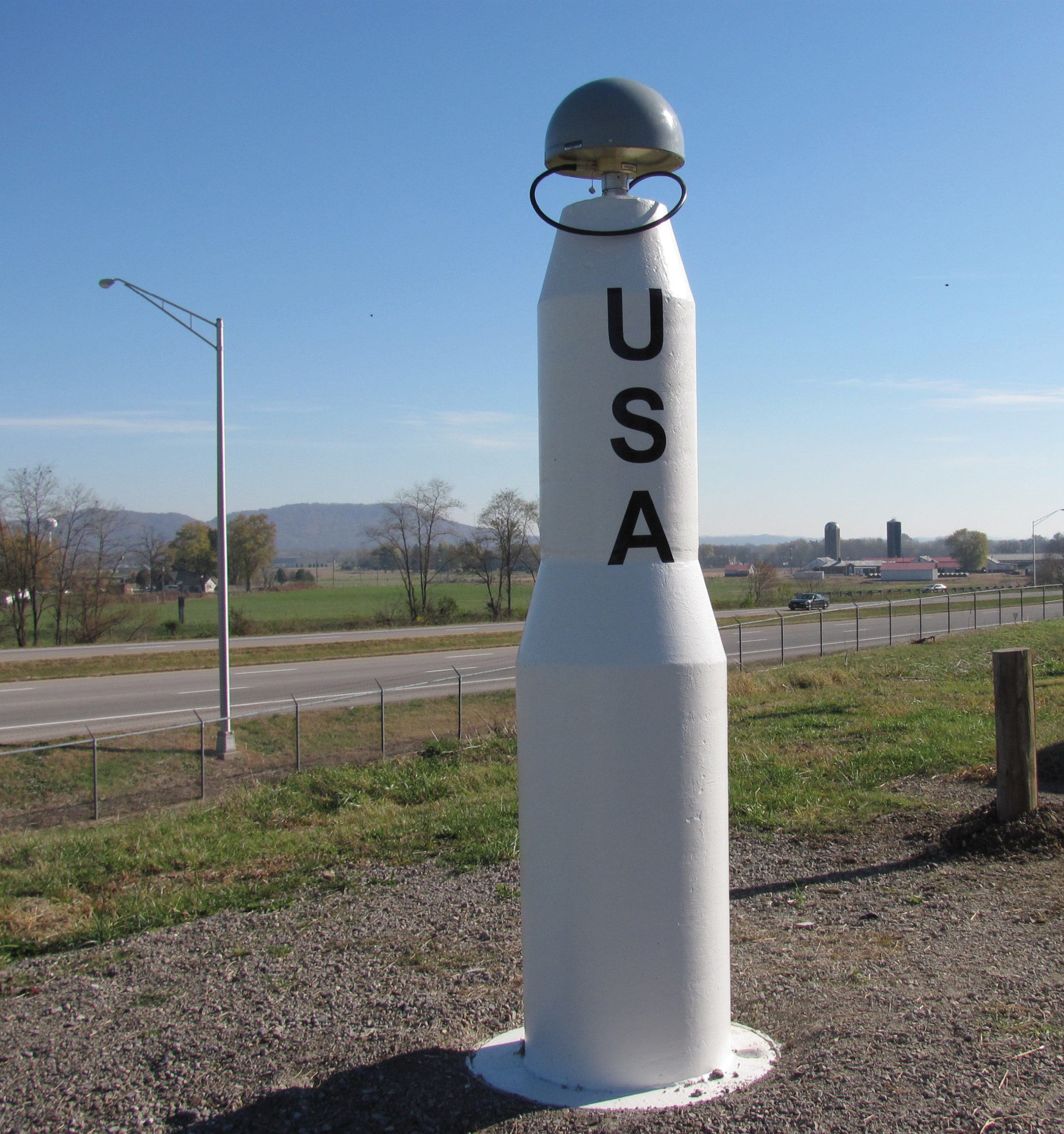
Nestled among the farms and highways stout reference station pedestals resemble Saturn V rockets paying homage to the Birthplace of Aviation.
From “The heart of it all” in the City of Columbus, the Ohio Department of Transportation has been pumping out a statewide RTN signal since 2004. ODOT provides “coast to coast” coverage from the Queen City’s “Nati” banks on the Ohio to Cleveland’s Northcoast on the Lake Erie shoreline. Ohio’s cadastre includes nine major survey systems and 46 sub-surveys as detailed by John E. Dailey, LS, in his fantastic article published in the December 2004 Edition of The American Surveyor Magazine.
The Buckeye State is also home to many historic transportation corridors including Zane’s Trace a.k.a. “The Old Cumberland Road” a.k.a. “National Highway” a.k.a. “U.S. Highway 40”. Foot trails, wagon roads, railroads and canals were all integral to society as the Buckeye State emerged from the untamed frontier wilderness. Today motorists leisurely enjoy a backdrop of woodlands, corn, and soybeans with little thought of the Trimble Real Time Network (RTN) that ties together people, highways, construction, and agriculture with property surveying.
 I had the great pleasure of meeting with a team of engineers and surveyors including Dave Beiter, Ray Foos, and Kolton Wilson at the Ohio Department of Transportation headquarters. Their charge is focal to the delivery of a larger mission upholding the public’s health, safety, and welfare which all revolve around providing a healthy and robust RTN. The ODOT team graciously offered up their institutional knowledge, information, and few “take-aways” from their statewide RTN operation. Beiter has been there since the beginning as the principal designer with nearly two decades invested in building and maintaining a successful RTN. Wilson and Foos both have been on this well seasoned team for seven years.
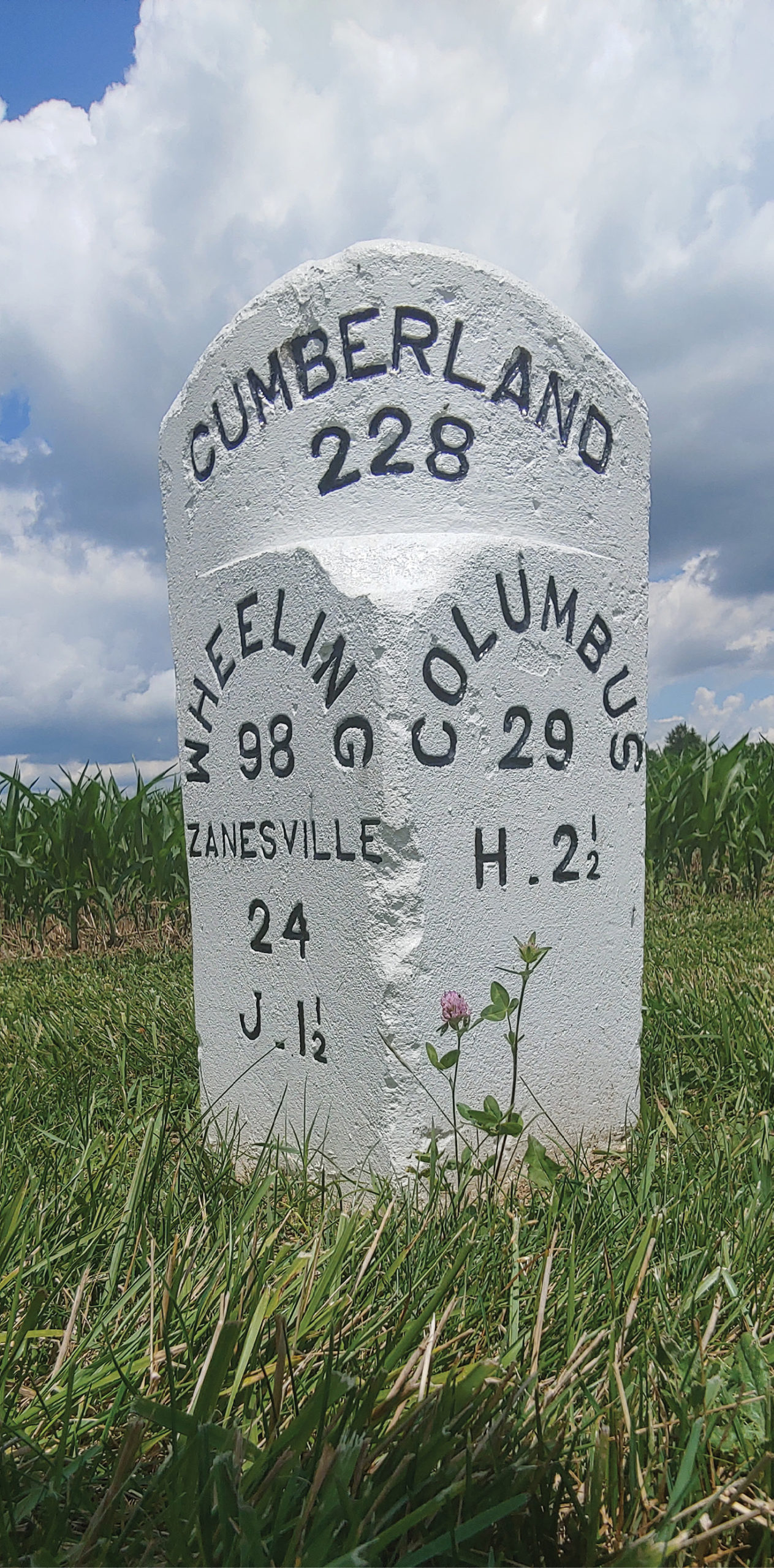
Original mileposts chaperon travellers along the ancient National Highway while just a few miles northwest the RTN provides guidance across Ohio’s ultramodern Smart 33 Highway Corridor.
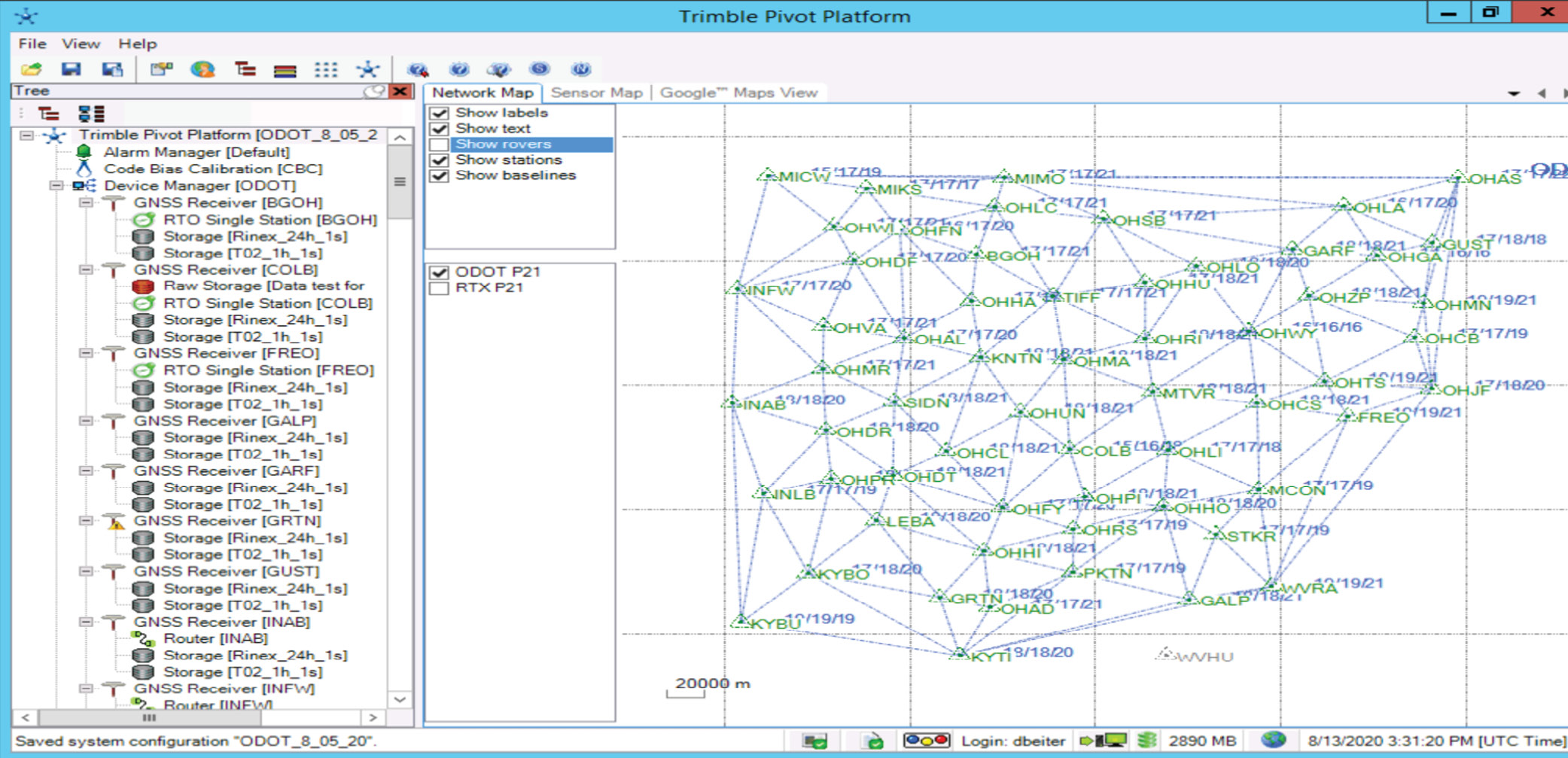
The system consists of 61 GNSS stations including data share sites from adjoining states. Stations were set at about a 35-kilometer interval. Beiter summarized the network geometry. “Ultimately sites were chosen based on the site itself. We had a set of parameters that we used to choose each site, those parameters included the following: Emergency power available, access to high speed internet, and site security. We also did Geotechnical assessments of each site to determine overall soil conditions and site stability. Finally, we performed a static data test where we set a receiver up for 1 week and let it collect data to check for cycle slips, noise, etc.”
Beiter mentioned data share sites with adjoining states. Cooperation between adjoining networks is a huge win for both the taxpayer and the user base. The ODOT RTN unites the most spirited fans of the deep seeded Steelers/Bengals/Browns rivalries and transcends the celebrated gridiron abrasion between The Ohio State University and The University of Michigan. Setting aside overly animated football fans, the RTN team has embodied hardware of every color from multiple geopolitical subdivisions by creating a seamless user network that truly improves our society. When we stop and think about it, this is an effort of biblical proportion and it requires a robust platform to pull it off.
Some considerations Foos recommends to an agency when selecting a network management platform are “using (both) a local dealer and the available technical support”. Foos advises to “get the software vendor and your firm’s IT infrastructure teams together from the beginning, that way all parties know what is expected and can work together to build a robust IT solution that will meet customer’s expectations.”
The ODOT RTN employs the Trimble Pivot Platform. Wilson shared that a large concern with platform selection is “compatibility with current, standard issue, GNSS equipment.” The Buckeye Network assimilates the diverse hardware and platforms utilized by the neighboring Hoosiers, Wolverines, and Mountaineers. This cooperative networking makes good neighbors out of otherwise fanatic sports rivals and saves taxpayers considerable resources. Coincidentally at the other end of Interstate 70 The Utah Real Time Network (TURN) is about the size of Germany and also leverages its adjoining state’s hardware through the Trimble Pivot Platform. Both the ODOT RTN and the State of Utah’s TURN network are pointing to an emerging trend of interstate collaboration through the Trimble Pivot Platform rather than the autonomous development of isolated, exclusionary and redundant virtual reference systems.
On both sides of the firewall Trimble Pivot software is the magic that provides real time user data and network statistics for the ODOT administrators. The ODOT team continues to provide a seamless user expirence whether it’s from the office desktop or the contemporary remote workplace.
Beiter strongly recommends agencies spend the time up front evaluating the platform software compatibility with firm’s IT security standards and protocol. Considering Ohio’s overarching investment in Information Technologies, the RTN Team’s selection of a platform really is an exercise in value added engineering.
A common theme heard among Trimble Pivot Platform users is that the platform leverages the strengths of the local IT system through the vendor’s intellectual solutions. The heavy lifting is performed by the vendor so the agency operator can focus on routine operations. Pivot also runs on each side of a firewall providing the public with its data while ensuring compliance with agency IT standards. That’s a huge win/win! Wilson also detailed how Pivot provides decision makers with performance measures. “The Trimble Pivot Platform utilizes an SQL database, on a separate server, to track and store statistics”.
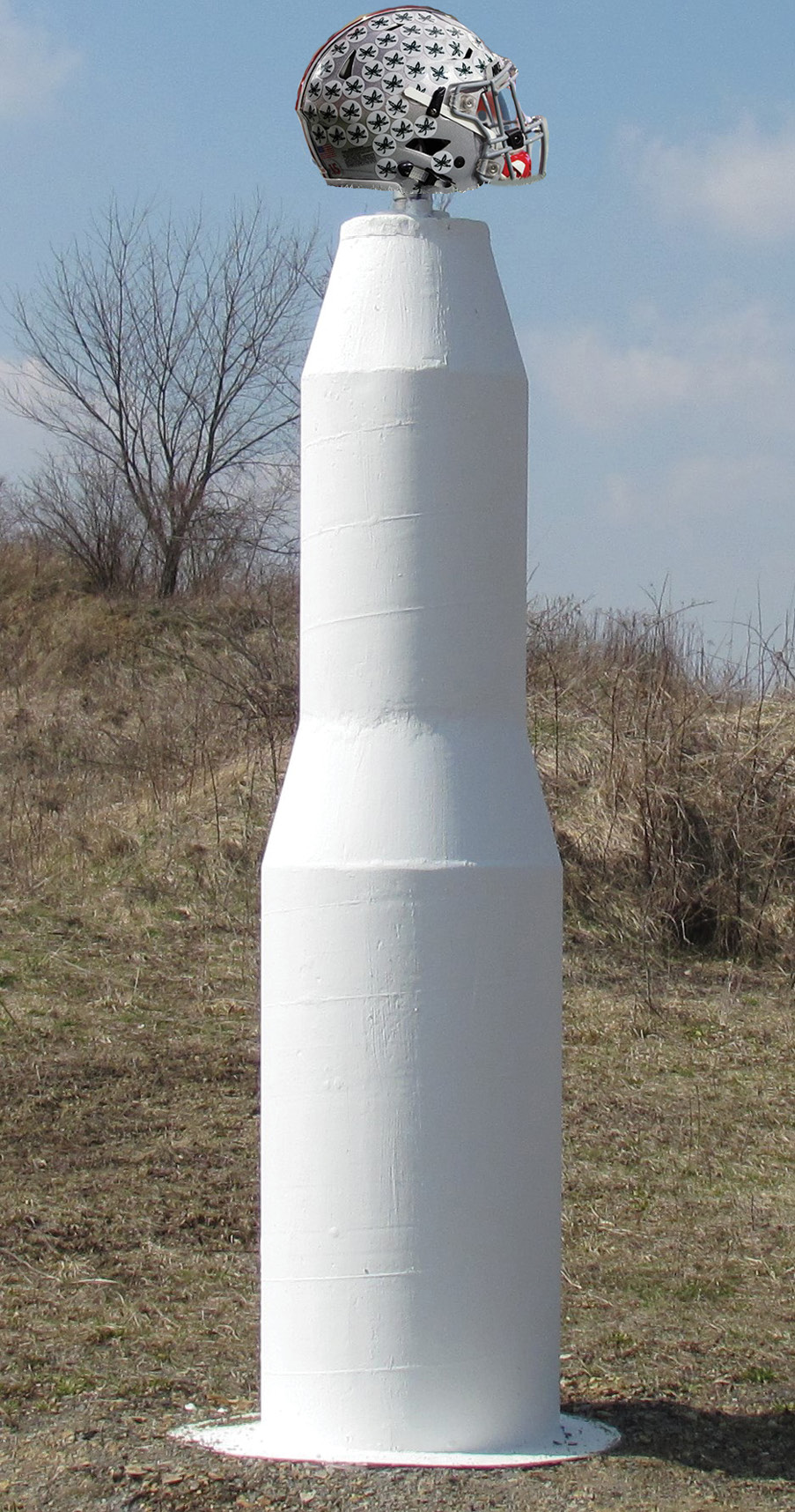
The ODOT team’s pride is reflected through the engineering design and construction of their CORS pedestals. Site selection was deliberate and well balanced throughout the network.
So according to these statistics is the RTN returning a dividend? You betcha! In 2019 over 5800 registered users had logged 564,000 hours. That’s the equivalent of 271 survey crews working full time for a year. In reality surveying is only a portion of that user base. It’s a good thing I’m not a betting man, and yes, I naturally assumed that the largest user segment would be surveying and mapping. It’s a really darn good thing my wager only involved the Browns making the Superbowl.
So how did the top five consumer groups stack up? In fifth place was “Construction” and they accounted for 2% of the use. The fourth-place consumer was the “Government” sector and it claimed over twice as much as “Construction” at nearly 5% of the total usage. In third place and claiming a sizable spike in consumption the “Utility Location” demographic pulled respectable 24% of total system usage. Second place was claimed by none other than the rope stretchers. “Surveying” accounted for 25% of the network usage. Shucks, that’s a big enough number to carry a local election without a recount in my neck of the woods. And the number one consumer of the ODOT RTN for 2019 was…the drum roll please… “Agricultural”, yes “AG” at a whopping 35% of the total usage. Beiter noted that “The Agricultural sector has been the leading consumer since 2009.”
I would be remiss to not mention the 6th place runner up. 2% of the usage was consumed by autonomous vehicles (AVs). We are currently just scratching the surface with AV testing. Can you imagine the consumption by AV’s over the next decade? ODOT is paving the way for AVs and in fact is developing the “33 Smart Mobility Corridor” with community partners. If you want a glimpse at the future just Google it. So back on point, the top two consumers account for 60% of the use and the top five nearly 91%. The statistics show that the system is paying off across multiple user demographics. In other words, this is a winner for everyone.
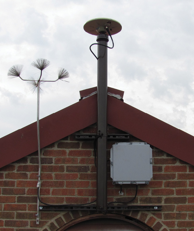
Above and below: The network freely assimilates many flavors of GNSS equipment without techincal prejudice via the Pivot Platform. The ODOT team has been able to leverage a variety of existing CORS stations including those from neighboring states.
ODOT couldn’t have picked a better ambassador for the RTN. Beiter is an engineer, surveyor, a farmer and the statewide real time network manager. He understands the seasonal demands of the survey and agriculture demographics. Gleaning from his experience as a network manager Beiter warns “Don’t plan vacations during peak planting season! Or you will spend most of your trip on the phone and laptop.” Once again, the Surveyor has adapted and expanded the horizons of our profession by accommodating the needs of a hungry market.
In addition to coordinating your IT team with the vendor, Foos bulleted some key lessons learned as the ODOT RTN is in its sixteenth year of operation. He emphatically offered that developers should, and I quote “TEST! TEST! TEST!”
 I truly was humbled by the high personal standards held by the ODOT team. These folks have every right to be proud of their accomplishments as well as their persistence and personal ownership of the project. Part of building a RTN includes projecting future requirements. Wilson suggests “Making sure that you have sufficient hardware capacity and capabilities, as demand will soon outmatch the base recommended specifications. Have a plan in place to upgrade equipment on a consistent basis. Yearly budgets tend to be inconsistent year to year so having a plan in place so you can buy equipment when money is available is very important.” The RTN team recognized that planning for contingency is just as important as any other operation. A poor user experience does no favors to network success. Beiter stressed “Redundancy is a must! Having a second server to load manage and take over if one goes down is essential to ensuring you have a reliable network. It also allows you to do maintenance and perform software updates without interrupting service.”
I met with the team in the summer of 2020. This year has been nothing but an unforeseen historic anomaly. Every imaginable facet of society has been really pushed to new boundaries. A RTN doesn’t run in a vacuum and the ODOT team was not exempt from some of the crazy goings on. The ODOT RTN team deserves a huge thumbs up for making it look so easy during some mighty stressful times. Choosing a robust platform and tackling the small details are big contributing factors. Being engaged all of the time appears to make the challenges more manageable as well. Beiter reflects on the current state of affairs, “Be upfront and proactive with users. This spring and summer were very unusual, due to the COVID-19 pandemic. With many people working from home and students taking classes from home, cellular/ internet latency became a LARGE issue in many areas. And as you know latency is death to a REAL TIME network. To give users a heads up, and to limit phone calls, I made a posting on an internet message board alerting the users to potential issues due to the latency”. I’ll take the liberty of embellishing this interview with the ODOT RTN team and speculate that the last thing standing during the zombie apocalypse may very well be ODOT’s Real Time Network driven by the Trimble Pivot platform.