Maysville, Kentucky, USA (September 23, 2020) — Carlson’s latest release of Survey, CADnet, and GIS 2021 brings users new features, increased speed, and more efficient workflows. Carlson 2021 comes with the power of IntelliCAD 10, the newly-released update to the CAD platform that brings increased speed, new features, and a fast, efficient new user interface for Carlson users, and is also compatible with AutoCAD 2017-2021. The 2021 release also delivers powerful new integrations with Carlson’s photogrammetry solution, PhotoCapture, as well as the ability to insert and manipulate BIM models in a drawing.
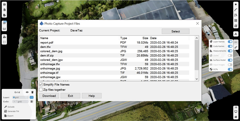 In Carlson Survey, you now have the ability to directly browse your Carlson PhotoCapture projects and download the results, including TIN surfaces, coordinate files, point clouds, and images.
In Carlson CADnet running on IntelliCAD, you now have the ability to insert BIM models from Revit and IFC format into the drawing. A new BIM properties pane allows you to select visibility for different categories in the model. You can also snap to points in the BIM model as well as draw new BIM objects including walls, doors, windows, stairs, and railings.
 IntelliCAD 10 brings a new graphics engine with faster performance and advanced visual style features. The side tool panel comes with key Carlson commands and supports drag-and-drop customization. Revision Control is now available to track changes, even across multiple users, and improved DGN commands now include dimensions.
Draw 3D Polyline now has the ability to draw 2D and 3D polylines simultaneously. With the 3D viewer open, the lines are visible in both windows, giving the ability to rotate the drawing in the 3D viewer to see the line in relation to the rest of your model.
Dynamic Point Labels automatically resize as you zoom in and out, keeping your point labels legible as you work within your drawing.
In the Carlson GIS module, more databases are now supported including ODBC and ESRI File GeoDatabase, both of which store both geometric and GIS data. This new functionality allows sharing of files between Carlson and third-party software such as QGIS and ESRI ArcGIS.
Along with Carlson Survey and Carlson GIS for 2021, Carlson Software is also releasing the 2021 versions of Carlson Point Cloud, Carlson Civil, Carlson Hydrology, Carlson GeoTech, Carlson CADnet, Carlson Trench, Carlson Construction, Carlson Mining, and Carlson Natural Regrade, all featuring their own industry-specific improvements. Bundle these modules together and save through the Carlson Civil Suite (carlsonsw.com/civilsuite), Carlson Takeoff Suite (carlsonsw.com/takeoff), or customizable Select Suite (carlsonsw.com/purchase).
Lead the field with Carlson 2021, now available for upgrade or new purchase. For more information about other enhancements in this new release, visit the Carlson 2021 webpage, www.carlsonsw.com/2021.
About Carlson
Founded in 1983, Carlson Software Inc. specializes in CAD design software, field data collection, laser measurement and machine control products for the civil engineering, surveying, GIS, construction, and mining industries worldwide, providing one-source technology solutions for the entire project cycle. Carlson Software is headquartered in Maysville, Ky., U.S.A., with branch offices in Boston, Mass.; Almere, The Netherlands; Brisbane, Australia; Ottawa, Canada; and York, England.
