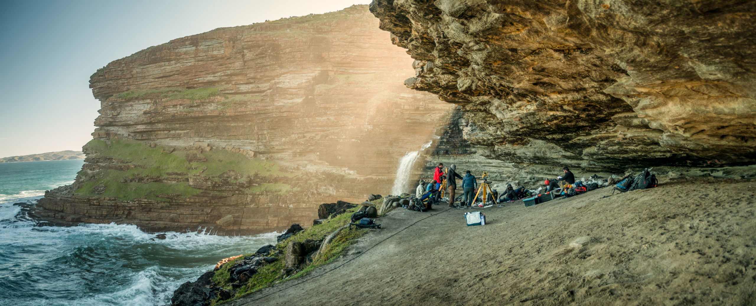
Excavations by the P5 Project at Waterfall Bluff rock shelter with the Mlambomkulu waterfall in the distance.
Part of being human is to grapple with big questions such as who am I and where did I come from? In the hollow of the day… that quiet time away from the chatter, ringing phones, daily demands, and obligations, the human mind can roam freely into a reflective state.
For some who like to know, to understand, and to reflect, the study of archaeology can satisfy the basic human need to know where we came from, and understand our own human nature. For them, the discipline of archaeology has two of the greatest advantages. For them, the discipline of archaeology is uniquely suited for these pursuits. Archaeology is the study of past people through the objects and places that they made and influenced. These artifacts and places are tangible windows into how our ancestors behaved in the past long eons after thoughts and memories have faded.
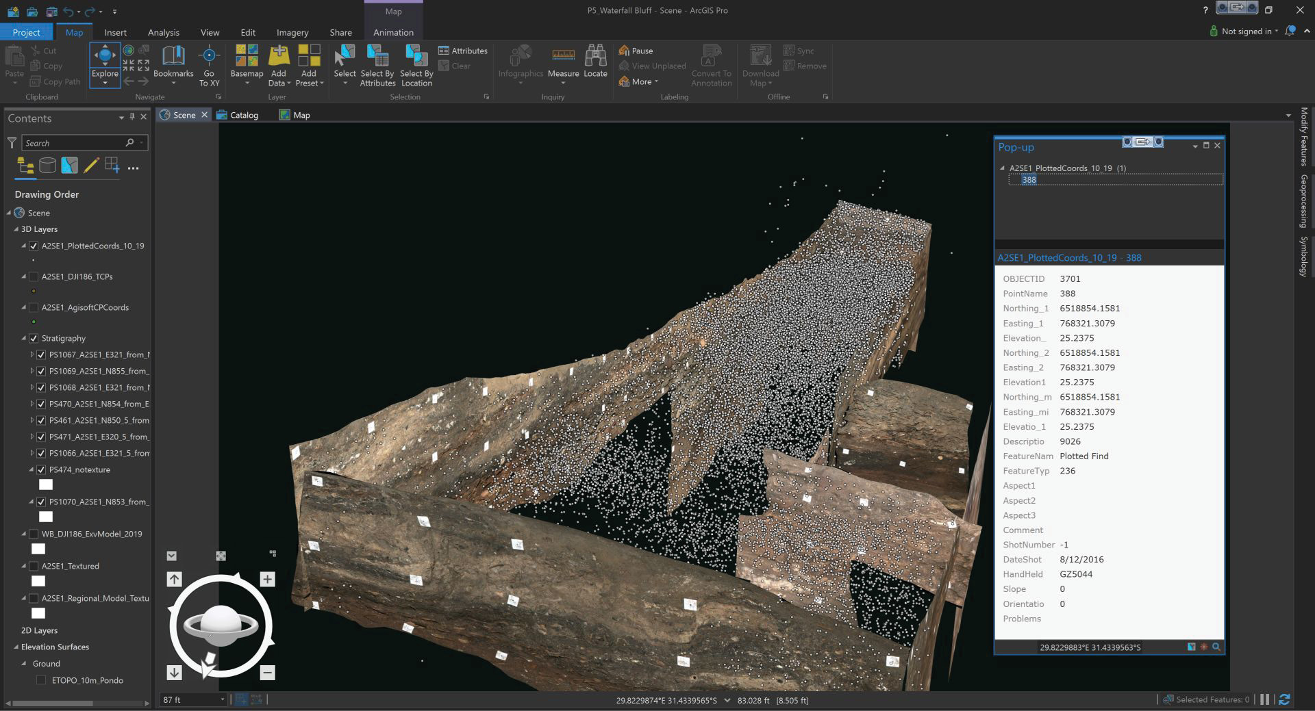
The Waterfall Bluff 3D GIS showing the 1 mm pixel resolution georectified photomosaics that line the main excavation area where every white dot represents a single artifact—piece of bone, stone, or other material—left from human occupations. The spatial patterns of these finds tell archaeologists how humans used the site in the past and how site use changed through time.
Archaeologist Dr. Erich C. Fisher has been adding to the knowledge base through his research of prehistoric hunter-gatherers who lived on the eastern coast of South Africa. Fisher is a research scientist with the Institute of Human Origins, School of Human Evolution and Social Change at Arizona State University. He started the P5 Project in 2011 and now runs the sprawling international and multidisciplinary research team with three other co-Directors. Dr. Hayley Cawthra, the chief scientist for marine geology at South Africa’s Council for Geoscience, Dr. Irene Esteban, an archaebotany expert at the Evolutionary Studies Institute at the University of the Witwatersrand, and Dr. Justin Pargeter, a specialist in stone tools and hunter-gatherer behaviors at New York University.

Aerial image of Waterfall Bluff.
“Scholars have long studied how people interact with their environment,” Fisher stated. “Like modern people, prehistoric hunter-gatherers are known to have adapted to changes in their local environments, influencing, among other things, what they ate, where they lived, what kinds of tools they made, and even how they interacted with each other.”
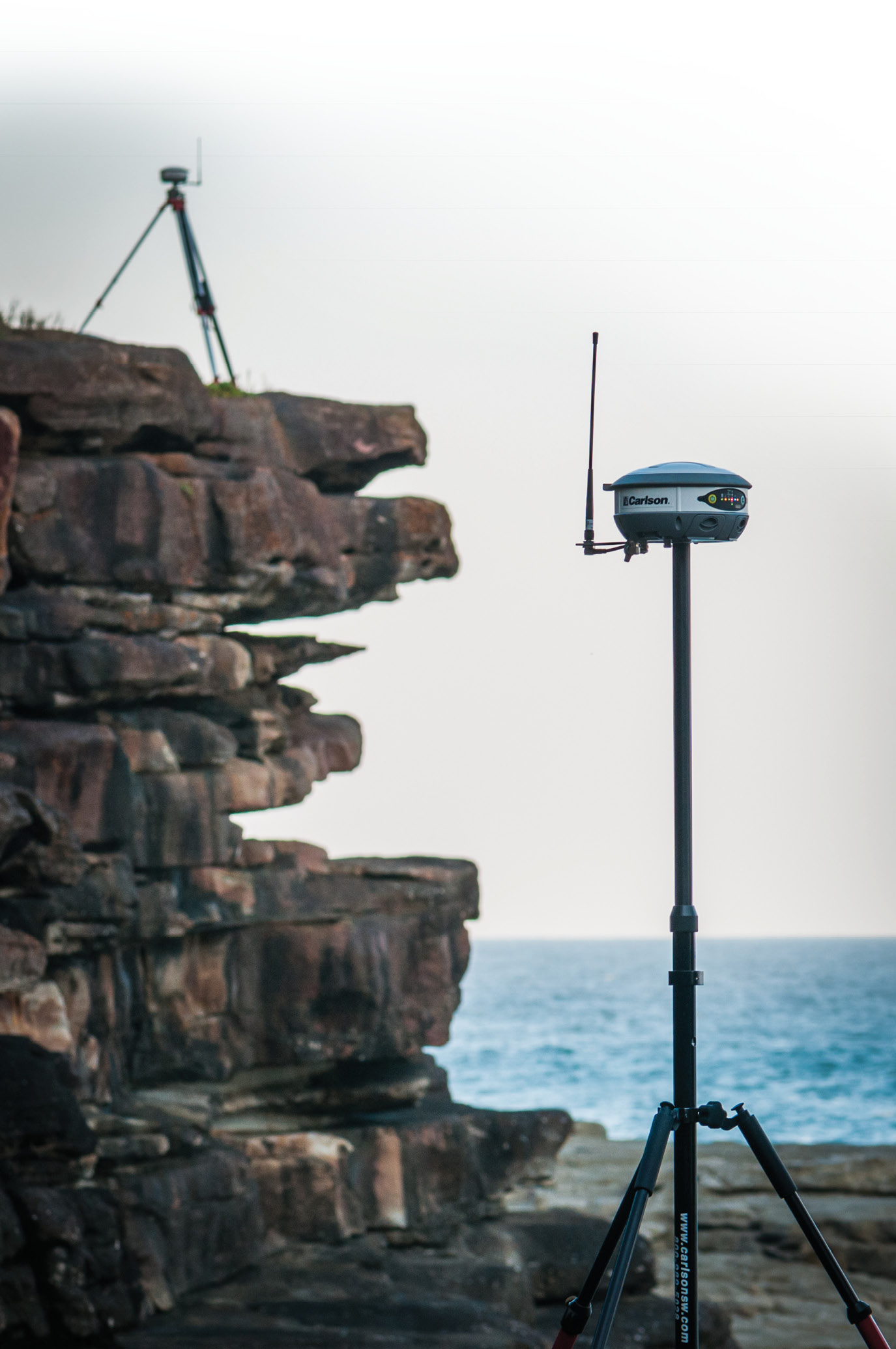
The P5 Project Carlson BrX5 base and rover on mapping assignment along the rugged coast around Waterfall Bluff.
“The archaeological sciences are ideally suited to studying the relationship between people and their environment over long timespans—spanning millenia—because these kinds of behavioral changes can be detected in archaeological records.”
Coastal zones intrigue scholars because their abundant, diverse, and predictable foods and other resources may have shielded people living in these places from the effects of rapid climatic and environmental changes. By understanding how humans adapted to coastal zones over long a time frame provides insights into the ways that people have coped. It also gives the broader scientific community a greater understanding of human impacts on coastal environments, which can help design conservation strategies.
In 2011, Fisher and his team began archaeological fieldwork in eastern Pondoland located in South Africa’s Eastern Cape Province. The P5 Project is an international multi-disciplinary project studying the origins and development of coastal foraging and the impact these resources may have had on the evolution of modern humans.

Mapping artifacts.
P5 stands for Pondoland Paleoclimate, Paleoenvironment, Paleoecology, and Paleoanthropology Project, which is a mouthful to say out loud. Paleo refers to the study of the past.
“The primary objective of our P5 research is to understand how hunter-gatherers lived in persistent coastal contexts during glacial and interglacial phases,” Fisher said. “So, we are testing questions about coastal ecological variability across glacial and interglacial periods and how these changes impacted hunter-gatherer food-choice patterns, social networks, settlement patterns, and technology. Secondarily, we are situating these data within the broader southern African paleo landscape to bring renewed focus on hunter-gatherer’s use of coastal and inland resources across glacial and interglacial cycles, which will provide a more nuanced understanding of human evolution and social complexity across broad bio-geographical contexts. The project’s interdisciplinary datasets, therefore, provide detailed insights into past human behavior, humans’ long-term impacts on coastal ecology, local environmental changes that influenced various biotic communities, and new methods to conserve these resources for future generations.”
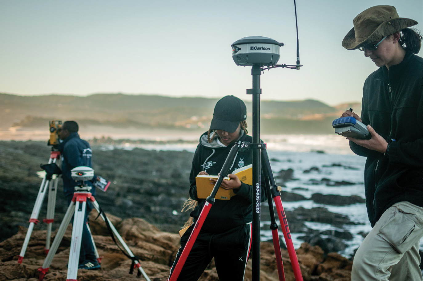
University of the Witwatersrand student Didintle Ramisode and University of Cape Town student, Patricia Groenwald, conduct a GNSS survey mapping outcrops of stone used to make stone tools.
To reach the remote Pondoland site, Fisher and his crew take a two-day drive from East London, South Africa to get to the area and then camp. They then must hike 1.5 miles to the site (and back!) every day carrying all their research computers, survey equipment, excavation equipment on their backs over rivers, up cliffs, and along the coastline.
As Fisher stated the archaeological record is, by nature, a highly fragmented and biased insight into past human behavior: “This is because any one record might only preserve a brief snapshot of people’s lives in the past and the environmental conditions but also because many of the most fragile remains, like plant foods, and even people’s thoughts do not preserve! So, what we are left with is highly fragmentary to begin with and made even more difficult to understand because natural processes like wind, water, animals, and even people have inevitably disturbed the sediments too. That anything has preserved over 1000 years much less 10,000 or 100,000 years is amazing, to be honest. And yet, with every scoop of our trowel those records are similarily destroyed, albeit in the name of science. Archaeology is unforgiving and there are no second chances. So, if we do not record everything at the moment it is discovered then unique and invaluable records may be lost completely. Thus, when we are excavating deposits that are, say, 25,000 years old we use the most exhaustive techniques possible because 1) it is ethically the right choice considering that our science is a destructive science and 2) maximizing data recovery allows us to answer more detailed questions about past humans and their worlds.”
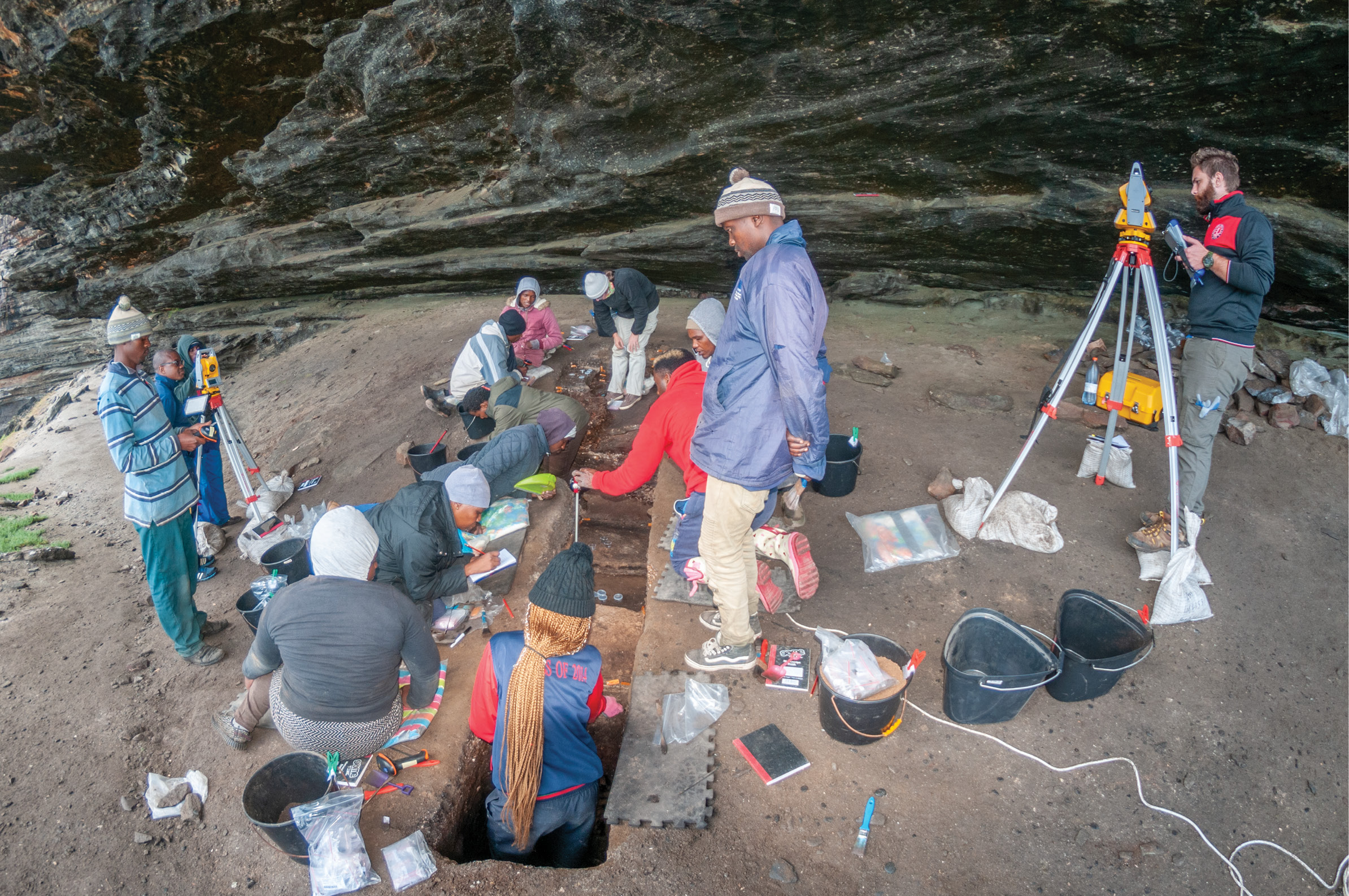
Excavations at Waterfall Bluff rock shelter, Eastern Cape Province, South Africa, May 2020.
Fisher is an archaeoinformatics specialist. Archaeoinformatics is a relatively new subdiscipline that uses the integrative framework that computing provides via analytical, visualization, and communicative tools to build intellectual bridges between researchers across disciplinary lines to tackle complex research questions using multi-pronged research strategies.
Fisher has experience surveying. During his PhD at the University of Florida, he took numerous classes in geomatics, cartography, and GIS. From there, he adapted that knowledge to his archaeological work (though, he admits “I am in no means on par with professional surveyors!”).
In the field, Fisher and colleagues now train students to run all of the survey equipment. Fisher also teaches classes in archaeoinformatics, which include GNSS and total station survey techniques in the field and in classroom.

Honors student (Univ. of Queensland) Josh Giesken teaches another student, Tatenda Tavingeyi from Great Zimbabwe University use Carlson SurvPC on a tablet to operate a total station.
“Our excavated point-plot data have all been integrated into a high-resolution and photorealistic 3D Geographic Information Systems model using ArcGIS Pro 2.1 and to a lesser extent, ESRI ArcGIS 10.6,” Fisher said. “The models allow our team to make detailed observations about the rock shelter, excavated archaeological deposits, cliffs, and surrounding coastal shelf to understand site formation processes and, ultimately, the context of the archaeological deposits.”
Fisher uses a very wide array of technology that is often not found in archaeology.
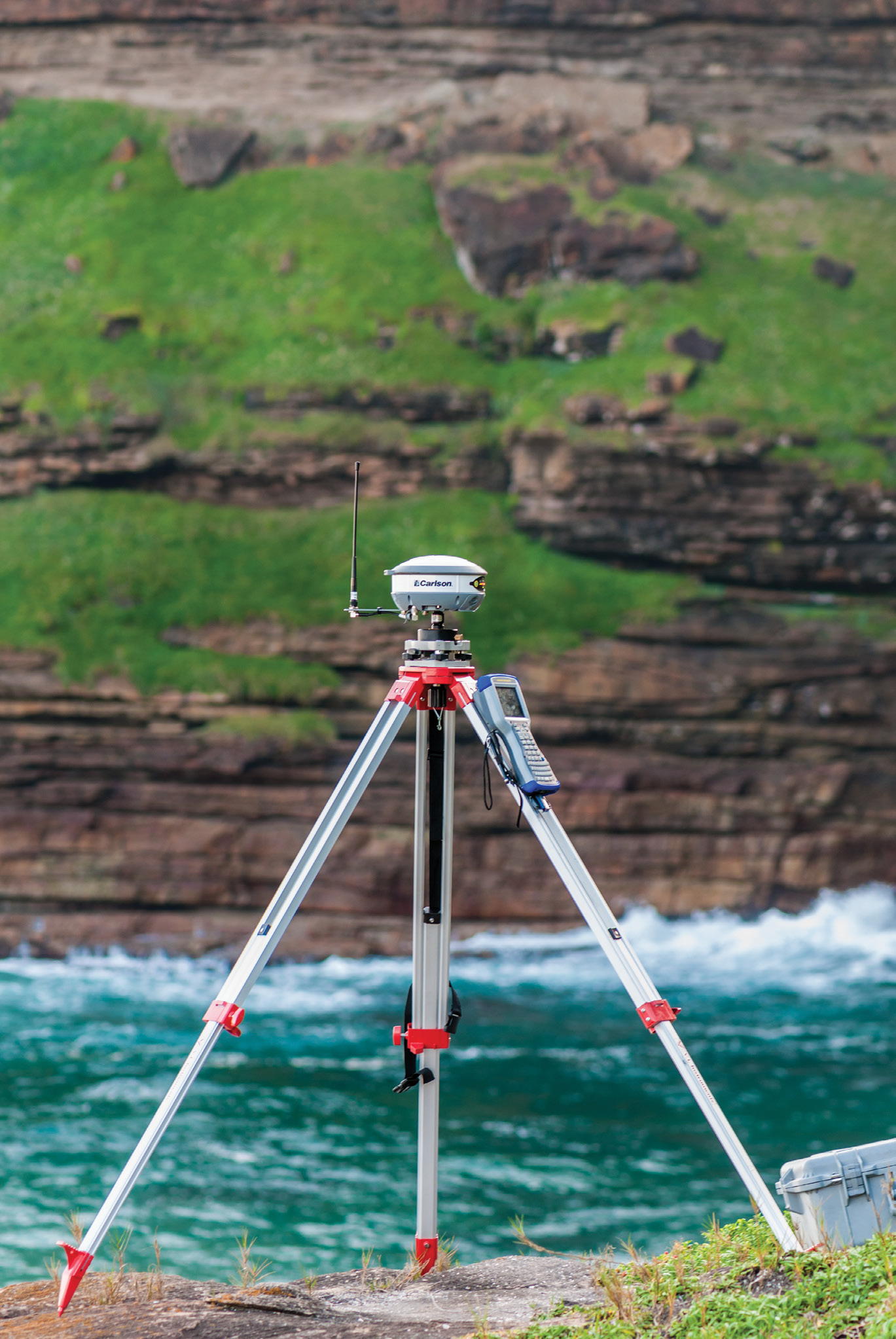
“For the surveying equipment, we have established a long and very close relationship with Carlson Software,” stated Fisher. “We use their software to run all total stations and GNSS, plus post-processing GNSS data, and we use their Carlson BrX5 for establishing geodetic control at sites.”
The P5 Project’s current research is focused on the site of Waterfall Bluff in Pondoland, where excavations have found evidence of Stone Age human occupations dating from the end of the last ice age during the Pleistocene, ca. 35,000 years ago, and the complex transition to the modern era, known as the Holocene. These records contain the first direct evidence of people eating marine seafood, like line fish and shellfish, during a glacial maximum, which has never been found in southern Africa. The well-preserved archaeological deposits also contain numerous records showing changes in climates, environments, and plant and animal resources for food and other daily necessities that includes almost perfectly preserved, and very rare, 11,000-year-old leaves.
 The exceptional quality of these records has allowed P5 scientists to create the first record of paleoenvironmental changes from a single archive that integrates plant pollen, plant phytoliths, archaeological charcoal, preserved plants tissues, and plant wax carbon and hydrogen isotopes. The long and detailed record of occupation at the site, which spans 20,000 years, also provides evidence that inhabitants at the site were either connected to other groups living in inland, highland, regions via trade or they were seasonally moving into these places themselves.
The P5 Project uses a robust catalog of modern techniques to document and reconstruct what life was like for hunter-gatherers at the end of the last ice age.
“Our geospatial mapping, for example, uses a combination of techniques to map our study region down to individual artifacts within the site itself,” Fisher stated. “We map our sites and surrounding areas using a combination of reflectorless total stations (Topcon ES- Series and Northwest NTS02S), RTK GNSS (Carlson BrX5), and forward facing geo-rectified parallactic1 photography via a DJI Mavic 2 Pro. At Waterfall Bluff, we used a Carlson BrX5 GNSS with a Carlson Surveyor 2 to establish geodetic control in front of the rock shelter. These data were post-processed using Carlson Survey GNSS 2016 and then we used those points for a closed-traverse into the rock shelter where we used side-shots to set up a network of interior control points within the UTM coordinate system. These control points now allow our team to resection anywhere within the rock shelter, supporting our archaeological and scientific activities therein.
 “We plot all excavated archaeological remains, like stone artifacts, bone, charcoal, and other debris from human activities in 3D using our reflectorless total stations. These total stations are operated from Bluetooth-enabled Windows tablets running Carlson SurvPC 6, which we have configured to use handheld barcode scanners to record vital tracking information about the provenience of everything within the excavations. All these data are subsequently integrated into a high-resolution and photorealistic 3D Geographic Information Systems model using ArcGIS Pro 2. These models allow our team to make detailed observations about the rock shelter, excavated archaeological deposits, cliffs, and surrounding coastal shelf to understand site formation processes and, ultimately, the context of the archaeological deposits. To date, we have mapped over 25,000 artifacts at the site.”
But beyond the diverse research at the coast, the Eastern Cape Province, where the project is located, suffers from a lack of teachers and resources resulting in one of the lowest college matriculation rates. Nationally, the situation is not much better with only 9% of black South Africans attending college compared to nearly 40% of white South Africans. To offset some of these issues P5 now advertises fieldwork directly to indigenous African students and covers their travel and living expenses. In 2019, for example, the field team included students from all major research institutions in South Africa, as well as as well as representation from the Kingdom of Lesotho, Zimbabwe, and Cameroon. Each of these students participated in excavations and many learned how to use Carlson software and to run the mapping equipment, giving them unique experiences and skillsets to aid their own careers. P5 is also engaged in grassroots efforts to support education and cultural and natural heritage preservation.
“Since 2015 we have also run an indigenous cultural heritage training program in partnership with the East London Museum, South African government agencies, and local amaPondo communities. The program supports local economic development through eco-tourism, creating liaisons with government officials to manage and preserve cultural heritage in Pondoland.”
Clearly, the efforts of P5 are contributing in productive ways from adding to the archaeologic record, to pushing the bounds of the new discipline of archaeoinformatics, to contributing to the Pondoland community, and, hopefully, giving additional insights to the eternal questions of who and why.
1 Editor’s Note: We were unfamiliar with the term parallactic mapping so we asked Dr. Fisher: “Yes, I would absolutely agree with you that the most correct term is photogrammetry. In my experience most archaeologists associate photogrammetry with either orbital or suborbital images of the Earth’s surface, but specifically facing down [nadir] or having a very low angle of the camera [oblique]. I got into the habit of saying “forward facing parallactic mapping” simply to reiterate to other archaeologists that don’t realize you can apply the same principles of parallax to derive 3D surfaces from overlapping images in a camera that is oriented in any way, including facing forward.