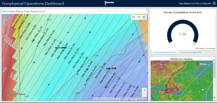
Fugro’s remote monitoring tools provided data to NOAA as shown on ship position, current weather conditions and sea state, as well as live survey data feeds.
Fugro has partnered with the US National Oceanic and Atmospheric Administration Office of Ocean Exploration and Research (NOAA OER) to establish a new ‘opportunistic’ approach for mapping deepwater areas of the US Exclusive Economic Zone (EEZ). As Fugro’s survey vessels transit to project sites through NOAA-identified areas of interest, remote command and control technologies are used to acquire high-resolution mapping data with minimal crew onboard.
A first test of the approach took place last autumn in the Blake Plateau region off the coasts of Georgia and Florida, resulting in 28 000 km2 of new EEZ mapping data delivered to NOAA in February. With only about 40 % of the US EEZ mapped and significantly less of the area characterised, the new Blake Plateau mapping data will contribute to the goals and objectives outlined in a November 2019 Presidential Memorandum on Ocean Mapping of the United States Exclusive Economic Zone and Shoreline and Nearshore of Alaska, which calls for bold action to map, explore, and characterise the ocean. Additionally, Fugro will contribute mapping data collected while transiting to and from the Blake Plateau project site as part of its ongoing crowdsourced bathymetry programme related to Seabed 2030.
“We are excited to partner with NOAA on such an important and ground-breaking project,” said David Millar, Government Accounts Director for Fugro in the Americas. “Over the past several years, we’ve developed and refined our remote service technology to streamline project schedules, reduce costs, continuously improve health and safety of our staff, and lower our carbon footprint. This same technology is utilised in the opportunistic mapping model. By leveraging the location and movements of suitable survey platforms, we can acquire high-accuracy, high-resolution bathymetry data with limited staff onboard. The approach is both efficient and cost-effective, and we believe it has tremendous potential in helping close bathymetry data gaps, not only in the US but all over the world.”
About Fugro
Fugro is the world’s leading Geo-data specialist, collecting and analysing comprehensive information about the Earth and the structures built upon it. Adopting an integrated approach that incorporates acquisition and analysis of Geo-data and related advice, Fugro provides solutions. With expertise in site characterisation and asset integrity, clients are supported in the safe, sustainable and efficient design, construction and operation of their assets throughout the full lifecycle. Employing approximately 10,000 talented people in 61 countries, Fugro serves clients around the globe, predominantly in the energy and infrastructure industries, both offshore and onshore. In 2019, revenue amounted to EUR 1.6 billion. The company is listed on Euronext Amsterdam.
