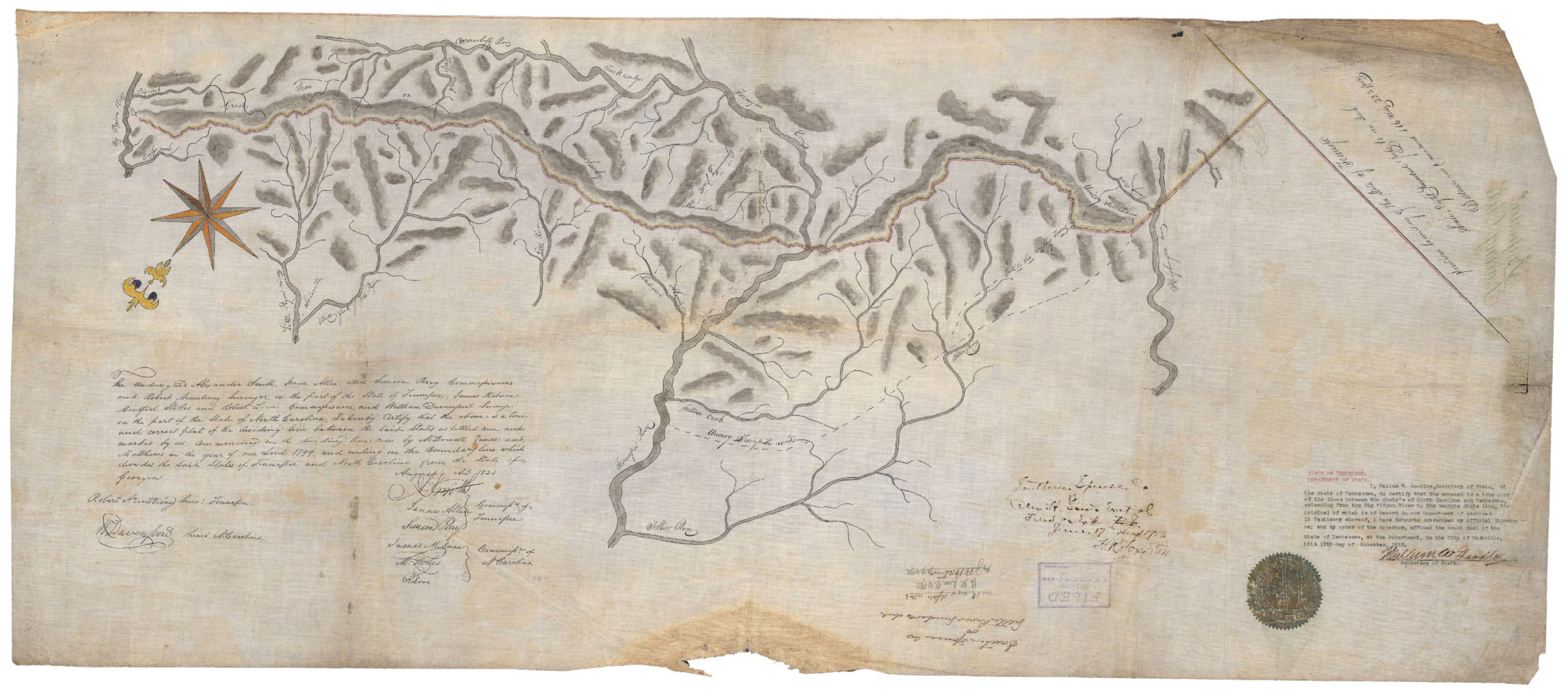
Boundary between North Carolina and Tennessee 1912 Imperial Tracing Cloth copy of the original 1821 Davenport Survey. Courtesy of the Digital Library of Tennessee
For about 100 miles the Appalachian Trail (AT) runs along the border between Tennessee and North Carolina. The last shelter in the Great Smoky Mountains National Park is nicknamed “The Smokies Sheraton”, but its official name is the Davenport Gap Shelter. Not many hikers know the real name or the history behind it—they just want a roof over their head and a place to dry out their gear. The history here though is immense and just a few miles down the trail the state line was so disputed it ended up in the Supreme Court. Before the highest court got involved, though, the Attorney General from North Carolina called upon the United States Geological Survey (USGS) to give an opinion on the location. The USGS appointed the State Line Boundary Retracement Specialist, Samuel Stinson Gannett, to retrace the 1821 William Davenport Survey demarking the State Line between Tennessee and North Carolina.
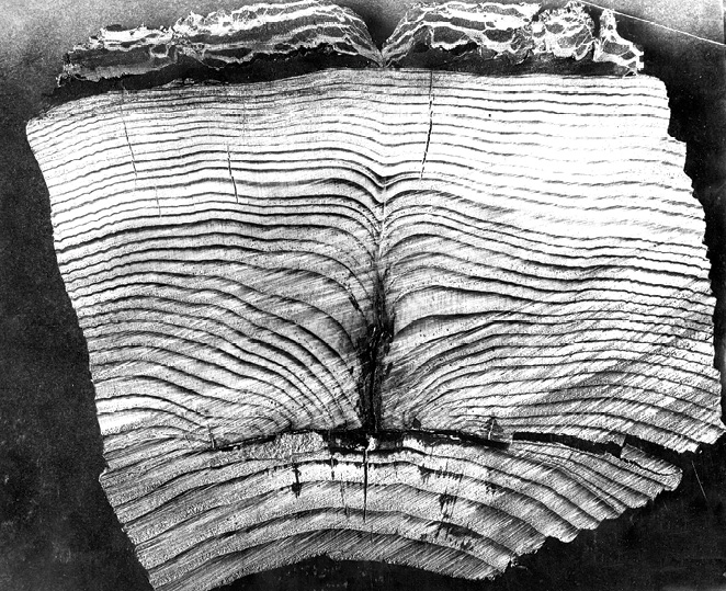
Section of fir witness tree, showing annular growth. Idaho and Washington Boundary Retracement. 1909. Courtesy of USGS Denver Photographic Collection
Section of fir witness tree, showing annular growth. Idaho and Washington Boundary Retracement. 1909. Courtesy of USGS Denver Photographic Collection
North Carolina became the 12th State on November 21, 1789. At this time it ceded part of its Western claim to the Federal Government for the expansion of new states. The Territory of Tennessee claimed this land and they eventually became the 16th State on June 1rst, 1796. The Act of Cession between North Carolina and the United States described the dividing line as “…thence along the extreme height of the said mountain (Great Iron or Smoky Mountain), to the place where it is called Unicoy or Unaka Mountain, between the Indian towns of Cowee and Old Chota; thence along the main ridge of the said mountain, to the southern boundary of the said state”1. When Tennessee came about they clearly used the same language. In their constitution they define the state line as “…thence along the extreme height of the said mountain (Great Iron or Smoky Mountain), to the place where it is called Unicoi or Unaka Mountain, between the Indian towns of Cowee and Old Chota; thence along the main ridge of the said mountain, to the southern boundary of the said state, as described in the act of cession of North Carolina to the United States of America2”. Right away both states agreed to have commissioners survey the agreed upon line, but only North Carolina actually acted upon it. In 1799 commissioners Joseph McDowell, David Vance and Mussendine Matthews surveyed (most) of the line with their crew. The main surveyors were Robert Henry and John Strother with a crew of six chainmen amongst others. This surveyed line was agreed upon by both States and not questioned until 1819 when the Treaty of the Cherokee was signed on February 27, 1819. It then became necessary to complete the line that was never quite finished in 1799. This time both states came to the table with commissioners. North Carolina was represented by James Mebane, Montford Stokes & Robert Love. Tennessee was represented by Alexander Smith, Isaac Allen & Simeon Perry. The surveyor in charge was William Davenport. The 1799 crew stopped about two and a half miles southwest of the Cattaloochee Turnpike. Davenport and crew started their survey at a “rock” at the Cattalucha Track, being one and the same as the Cattaloochee Turnpike, known today as Mt. Sterling Road in Haywood County, North Carolina—most likely a stone set from the 1799 crew. For hikers on the AT this is fittingly called Davenport Gap. They marked this rock “N.C. 1821” and “T.E.N. 1821”. They then ran “…with the line the J M Dowel M. Matthews & D. Vance run in the year 1799…” for the next two and a half miles3. Davenport’s notes were meticulous—that is once they were found. On November 10th, 1910 the great-grandson of Davenport found a secret drawer in a sideboard cabinet. Inside the secret drawer was the only known copy of the field notes of Davenport’s 1821 Survey. The book was six and a half inches by four inches and stitched together with coarse thread. The front and back were covered with heavy brown paper and was noted to be “…in a perfect state of preservation”. This find would end up being a game changer for the dispute that would erupt later on in 1910. The only known, original, map of this expedition has also disappeared, but was luckily meticulously hand traced on Imperial Tracing Cloth to the finest detail prior to being lost.
Map of Transit Survey [By Gannett] of a Section of the State Line between Tennessee & North Carolina. Courtesy of Reference Librarian Rebecca Bryan at the University of Tennessee Joel A. Katz Law Library
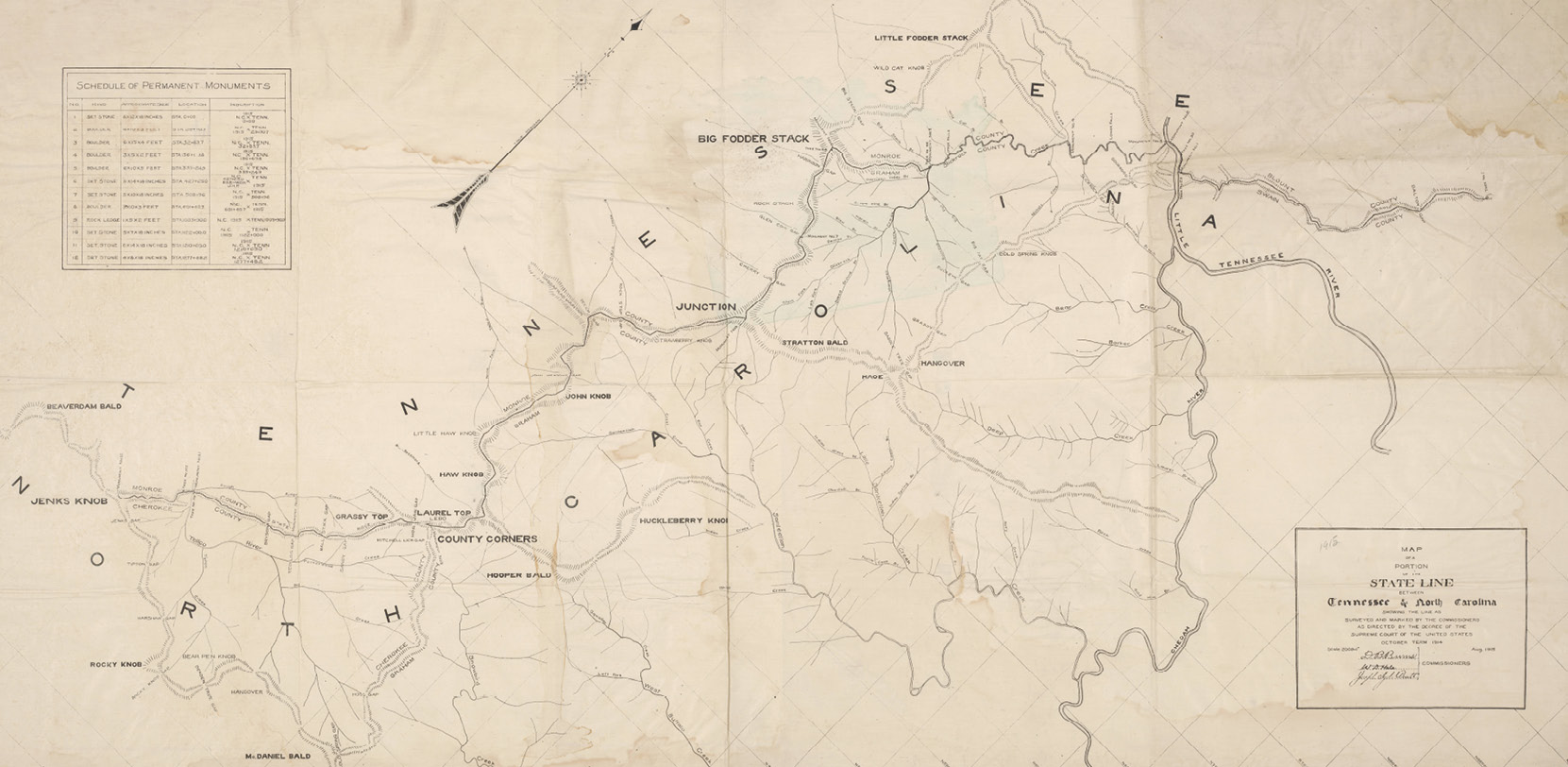
Map of a portion of the state line between Tennessee & North Carolina showing the line as surveyed and marked by the commissioners as directed by the decree of the Supreme Court of the United States, October term, 1914. Courtesy of North Carolina MAPS/State Library of North Carolina
After his survey, Guyot’s nephew produced a map of his findings and ultimately showed that he drew a portion of the State Line in a position different than that of Davenport in 1821. To complicate matters, the U.S. Coast Survey published his findings in a map compiled by W.L. Nicholson and A. Lindenkohl, appropriately nicknamed the Lindenkohl Map of 1865. In 1892 things boiled over and the first suit was filed. The main argument in the case was what defined the “main ridge” and the “extreme height” as stated in the Act of Cession between North Carolina and the United States. Arguments continued over the years as to the location of two main sections of the State Line, the Slick Rock Section between the Little Tennessee River, through Big Fodder Stack, and Junction and the Tellico River Section between County Corners and Jenks Knob.

A Map Showing the Disputed Sections between North Carolina and Tennessee.
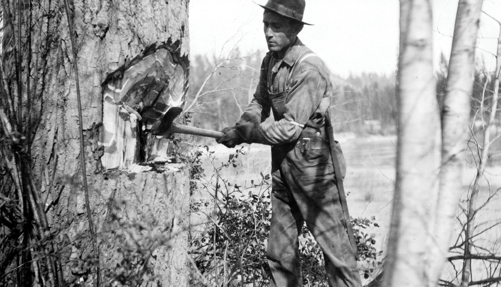
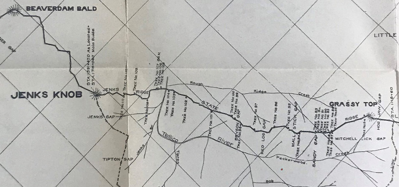
It was in April of 1910 that Gannett got involved and started with his fieldwork—at the request of the North Carolina Attorney General. This was not the first time in the Smokies for Gannett as early in his career he did triangulation work under Professor Washington C. Kerr starting in 1883. This work was done under the 2nd director of the USGS, John Wesley Powell and Chief Geographer and Samuel’s older cousin Henry Gannett. Along with D.B. Burns and other crew members, Gannett retraced the line as surveyed by William Davenport in 1821 and ultimately agreed upon by both States. He was able to prove the true location of the Davenport Survey by finding line trees hacked upon by the crew in 1821. Without a doubt he was on the same line as Davenport. In 1821 Davenport marked a Holly Tree at the 86th Mile. In April of 1910 Gannett found “…a holly 16 inches in diameter, decayed on south side, two hacks and blaze on north side; marked on west “86 M”; the holly is 8 feet north of decayed hemlock, 38 inches in diameter; side line tree”. The holly was stationed at 1332+07 and identified as Tree 107 in the 1910 Survey, and lies about 800 feet southwest of the crossing of the Tellico River. Gannett and Burns blocked a tree around the 101rst mile and counted the rings exactly at 88. Between County Corners and Jenks Knob alone Gannett found and identified twenty trees that were marked in the survey of 1821 and between Big Fodder Stack and Junction he found over two dozen additional marked trees. In total Gannett found and identified 47 marked trees from the survey of 1821 between the Little Tennessee River and Junction. There was no question whatsoever that the line they were retracing was the 1821 Davenport Survey. They then continued on the line past the end of the disputed section(s) and surveyed and proved the Davenport line all the way past the Little Tennessee River to the 59th Mile—almost to Gregory Bald. The 59th Mile tree was a 36 inch Mountain Oak with “59” carved into it with numbers being 12 inches tall. Davenport called this a Red Oak in his notes. Gannett used the same methods, and instruments, as he did on the 1908 survey between Idaho and Washington when he retraced the 1873 Rollin Reeves GLO Survey.
The actual survey of the disputed sections for the Supreme Court wasn’t accomplished until August of 1915. This survey was ordered by a decree issued in the October Term of 1914. The commissioners for this survey were D.B. Burns, W.D. Hale and Joseph Hyde Pratt. Burns was alongside Gannett in 1910 and very familiar with the State Line already. Pratt had a most distinguished background. During his career Pratt was a professor at both Yale and Harvard as well as being the State Mineralogist and Geologist for North Carolina. He also worked for the USGS as a field geologist and was the author or multiple books and hundreds of papers. The survey work started where Gannett ended—the 59th Mile Tree from the 1821 Survey. It was now identified as Tree No. 1 and was a towering Red (Mountain) Oak marked on the Southeast Side “59 M”. The crew surveyed Southwest setting stakes and marked stones like Monument No. 6. It was a “…Stone 5 inches thick, 14 inches wide and 18 inches high, and on it we cut on the southeast side N.C., 427+25.0, D.B.B., W.D.H., J.H.P., on the northwest side TENN., 1915, and an X in the top”. Again the 86 Mile holly tree was passed after setting a marked Stone, identified as Monument No. 11, at Station 1210+69 on the Northeast Side of the Tellico River. Their survey ended at Jenks Knob and according to their final report“… at the end of the contention in this cause”5.
The survey by the commissioners matched that of Gannett almost exactly as it also matched the 1799 and 1821 Surveys. The Supreme Court ordered “…that the real, certain, and true boundary line between the States of North Carolina and Tennessee between said certain points is as delineated in the said report and on the map…”
Gannett was called to testify as to his 1910 Survey in front of the Supreme Court and his knowledge and experience no doubt made the 1915 survey much easier. Gannett couldn’t be at two places at once though as he inevitably would have been called to do this survey. He was however on a different survey at that time, my favorite survey, the one between the States of Ohio and Michigan.
4 Great Smoky Mountains Colloquy, Spring 2010, Volume 11, Number 1, Page 1.
5 United States Reports, Volume 240, Cases Adjudged in the Supreme Court at October Term, 1915. Charles Henry Butler. The Banks Publishing Company, New York, 1916.