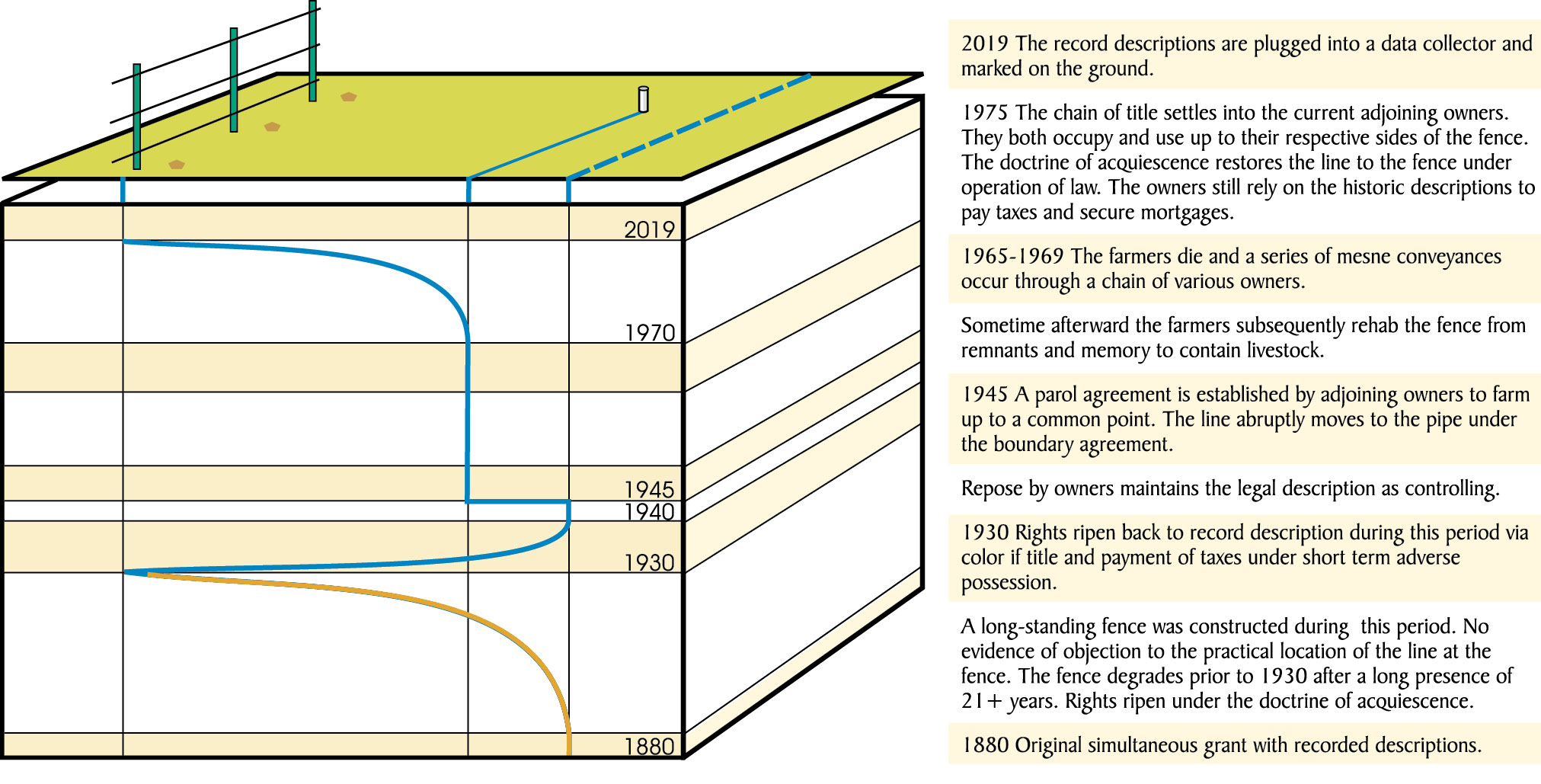
Thought provoking scenarios arise with a migratory influence of unwritten title. Evidence includes the element of time. Despite the operative transfer’s abrupt nature, the persuasion of the evidence fits curvilinear trends when considered on the ground. Note that the boundary appears most stable when the owners are in clear agreement of a fixed position.
I feel that the surveyor best represents a boundary when we represent that which the owners have expressed as the true boundary on the ground. I don’t just mean your client or just his deed, but rather both chains of title on each side of the line from day one of the original subdivision. It’s not a light task. Simply puppeting deed calls on the ground has proven problematic despite a basis in law. Conversely the surveyor who trades his rope for a robe and takes license to adjudicate a broken cadastre might just be hung from that same rope. What danger lurks among those two extremes? Well, there’s the legal doctrines of acquiescence and adverse possession for starters. The Utah Supreme Court recently revealed the legal complexities of these related concepts and how they commingle throughout the life of a chain of title. Sorry, not much bob dangling this month but a lot of head scratching is promised for anyone that makes it to the end of this read.
The Case of Q2 LLC v. Hughes is a trip through the space time continuum, at least when it comes to boundary dispute cases. The Court was asked “…to decide only one issue in this case: how and when does a party acquire title to property under the doctrine of boundary by acquiescence?” The Court further broke it down into “…Does title transfer by operation of law at the time the elements of boundary by acquiescence are met or by judicial decree at the time the trial court enters its order?” Understandably this question also piqued the interest of Utah’s land title community and they jumped on the appellate bus in amicus. Well, as a surveyor I thought this was an intriguing question but I do recognize that solving matters of law doesn’t fit in my vest pockets or stake bag. So there’s the disclaimer of the month.
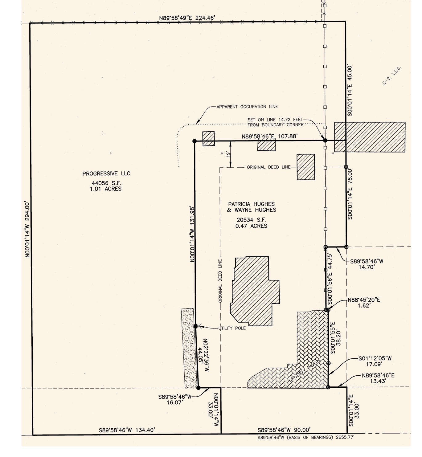
A record map of the scene shows a jog in the line that seems to fit occupation.
The answer in Utah is that title transfers at the time the elements are met and it’s automatic. The Court summed up their role as follows “The precedent found in Brown and Veibell controls the issue before us, and we take the opportunity today to reaffirm our prior decisions by explicitly stating that the doctrine of boundary by acquiescence grants title by operation of law when its elements are met. The doctrine simultaneously extinguishes the previous owners‘ legal title and leaves them with only bare record title.”
Okay, that’s how the cards played out, now here is their reasoning. “To be sure, there will be cases in which judicial adjudication becomes necessary to resolving disputes, but a judicial adjudication of a boundary dispute does not itself confer title. Rather, it merely determines the prior point at which title vested.” That is my emphasis added to show the Court’s role in the deal. FWIW it makes sense to me. The title companies don’t like it because rights can be harbored outside of the record. I see their dilemma and uneasiness when the Court introduces terms like “bare record title”.
So we apparently have two adjoiners on the other side of the Hughes line. Facing from Hughes side, let’s just assume the left and right adjoiners are Q2 and Dahl respectively. The subject fence cuts off a swipe of Hughes property along the entire length of the line. Precedent to Hughes taking title there was the reliable fence from 1927 to 1971, a varying description, and occupation all happening on the ground that ripened favorably to adjoiner Dahl. Hughes lost a portion of their claim to Dahl at trial then Hughes appealed. The court of appeals upheld the trial court‘s order in 2004, rejecting the Hughes arguments that the deterioration of the fence and their non-acquiescence to the fence line defeated Dahl‘s claim. This nailed down our “right half” of the line under the doctrine of acquiescence in the 2004 case. A few years later Q2 brought suit against Hughes for the left half of the line holding the exact same fence line and argument as Dahl. Seems like a no brainer and reasonable, right? Well, this is where the whole time space continuum thing kicks in.
 The Court determined that Dahl acquired title under acquiescence no later than 1971 and this vacated the adjoiner’s title (Hughes “predecessor”). So the fence is the boundary as of 1971 and the record description is consequently inaccurate at that time. Ironically, the same doctrine that offers repose under acquiescence also creates an adverse possession potential for the loser. Yup, and Hughes proved it. After 1971 the fence degraded and in 1998 Hughes took possession of the property per the historic but legally inaccurate record description. Okay, ya’ can’t convey what you don’t own so Hughes never took title to the acquies-ed strip, right? Right! The Court pointed out that Utah’s adverse possession doctrine doesn’t always fly because it includes the payment of property taxes. “…one who possesses land for a long period without having legal title, but believing he is the actual owner, is unlikely to think of procuring a tax description in order to pay taxes on the land because he will think that he is already paying taxes on it.” A rare bird was hatched with the 1971 operative transfer to Dahl and Q2 under the doctrine of acquiescence. The tax folks weren’t notified of the operative boundary change so Hughes and “predecessor” were still stuck with the tax bill for that strip of property. That of course was inarguably substantiated with the ripened Dahl claim observed by the court.
According to the Utah Court adverse possession needs actual possession that is open and notorious, hostile, exclusive, continuous, and accompanied by taxes or color of title for five to seven years. All of those except the time, taxes, and “actual” may have occurred in “Hughes” favor operatively at the moment title transferred in 1971. By 1978 the time, taxes, an “actual” could have also accrued under the predecessor. Hughes took title 1998, so not counting any tacking they could have wrapped their adverse claim up by 2005. Q2 notified Hughes of their trespass in 2005 and took action in 2008. The long story short is that Q2 did actually pull the carpet out from under the predecessor in 1971 through acquiescence then Hughes spun the table and took it right back in 2005 under adverse possession. I suspect ownership could ebb and flow under operation of law in perpetuity. Let that soak in!
The doctrine of acquiescence is an evolving concept. The Utah Court worked through an acquiescence question in the 2016 case of Anderson v. Fautin. Early Utah Courts associated acquiescence with an agreed boundary. Evidence or inference of the parties mutually behaving was required to sustain a claim. Later courts have found that acquiescence is more akin to adverse possession and have abandoned any mutual occupancy requirement. I wildly speculate this evolution might reflect concerns arising between actual occupants and absentee title holders. The term seisin comes to mind but I’ll check my chain tension before I record that in my field book.
The law somehow arrives at the conclusion that acquiescence is a conveyance. That seems counterintuitive doesn’t it? Let’s break this down a little bit. If a boundary is known and the parties want to change it, well that’s a conveyance and they need to follow the laws of conveyancing. If someone possesses land and doesn’t hold title then that land can be conveyed according to law under adverse possession. Here’s where the waters start to muddy. When adjoiners do not know where a boundary is they can fix that line by agreement. Agreement can be written (best), oral (okay till somebody dies), implied through use, actions, or acceptance, and last but not least inferred by a court. This is a cheap simplification of the legal standards so please, a grain of salt. Considering those elements it’s easy to see why the earlier courts associated acquiescence with the agreement doctrine. Okay let’s get something clear, the term “uncertainty” is broad but in the strongest sense might include a broken description, a broken chain of title, an ambiguous natural monument, no original survey or marks to retrace and no reliable occupation. I wouldn’t expect a surveyor to be able to competently retrace such a boundary and the best the owners can do is just get something to work between themselves. So that’s a full-blown agreement and operatively the title is momentarily bubbled together, vacated, and then immediately redistributed equitably at the owners’ free will. The bubbling and redistribution part seems necessary and evokes thoughts of a quitclaim conveyance.
On the other hand when chains of title are harmonious and descriptions are reasonably intelligible the adjoiners may find it necessary to simply fix that title line to the best of their ability. It might be done with a tape measure, a lawnmower, a hedgerow, a driveway, or through any conceivable improvement, but it is nonetheless done. This is the owner’s expression and interpretation of that platted line between lots “such and such” in “whatever estates” subdivision. By the way, we see a similar circumstance within the subdivision of sections. Now, we all know where everything is “supposed” to land respectfully by measurement from the block and section corners. Despite our astonishing ability to precisely repeat recorded measurements from a grantee’s receipt, the facts may be that the owners were left to pack their own groceries at the checkout line. This is true of the interior of the vast majority of G.L.O. sections. This is also a common occurrence in many residential subdivisions laid out prior to our contemporary local land regulation practices. So, exercising repose with respect to a bona fide delineation of an original grant has been a long standing function of the surveyor. For the record I’ll call that Cooley’s doctrine of repose. Nobody is giving or taking or selling or conveying or doing anything except marking their claim. These owners know they own no more and no less than the lot they bought according to the title papers and the Assessor’s records. They also know that the neighbors used to be really nice folks until the last block party and everybody still mows to the marker somebody set or found years ago.
The issues in Q2 v Hughes and the 2016 Utah case Anderson v. Fautin are questions of law and it’s pretty clear that “measurements and monuments” were not issues in these cases. It’s also clear that boundaries can ebb and flow repeatedly or more aptly snap back and forth under operation of law. We also learn that a dimension of time can be applied to evaluate operative conveyances in an unwritten chain of title. The law looks for evidence of resolution or repose. However, the visible characteristics of occupation and written title may not reveal the extent or complex questions behind ownership. My prism pole is not a magic scepter. If retracement work reveals a conflict then further action is required by the owners’ to complete the boundary survey. They must offer resolution or repose where the former might include a new record partition and the latter would substantiate the existing record description. Either way is fine by me. I just need an answer before I finalize my boundary survey.
A special thanks to Surveyor and Attorney Mark Gregersen of Gregersen Law in Salt Lake City, and Surveyor John Stahl of Cornerstone Land Consulting in Sandy, Utah for sharing the Utah cases of Q-2, Anderson v Fautin, and Bahr v. Imus. I encourage every student of boundary surveying to read up. The plat provided is of public record however Reeve & Associates, Inc. requests potential users to obtain permission prior to use. The surveys show that things really weren’t as cut and dried as detailed by the court decision. I have found this to be at least not unusual when researching decisions. I had the pleasurable opportunity to chat with Daryl Penrod who is still practicing locally with his current firm of Ludlow Engineering and Surveying outside of Provo, Utah. Daryl confirmed that there were some additional moving parts to this puzzle and there’s always more to the backstory. Feel free to contact me at jason.foose@chevesmedia.com with any questions or comments.
The case can be found here: https://amerisurv.com/wp-content/uploads/PDF/Q2VersusHughes.pdf
The Report of Survey can be found here: https://amerisurv.com/wp-content/uploads/PDF/Q2versusHughesPlat.pdf