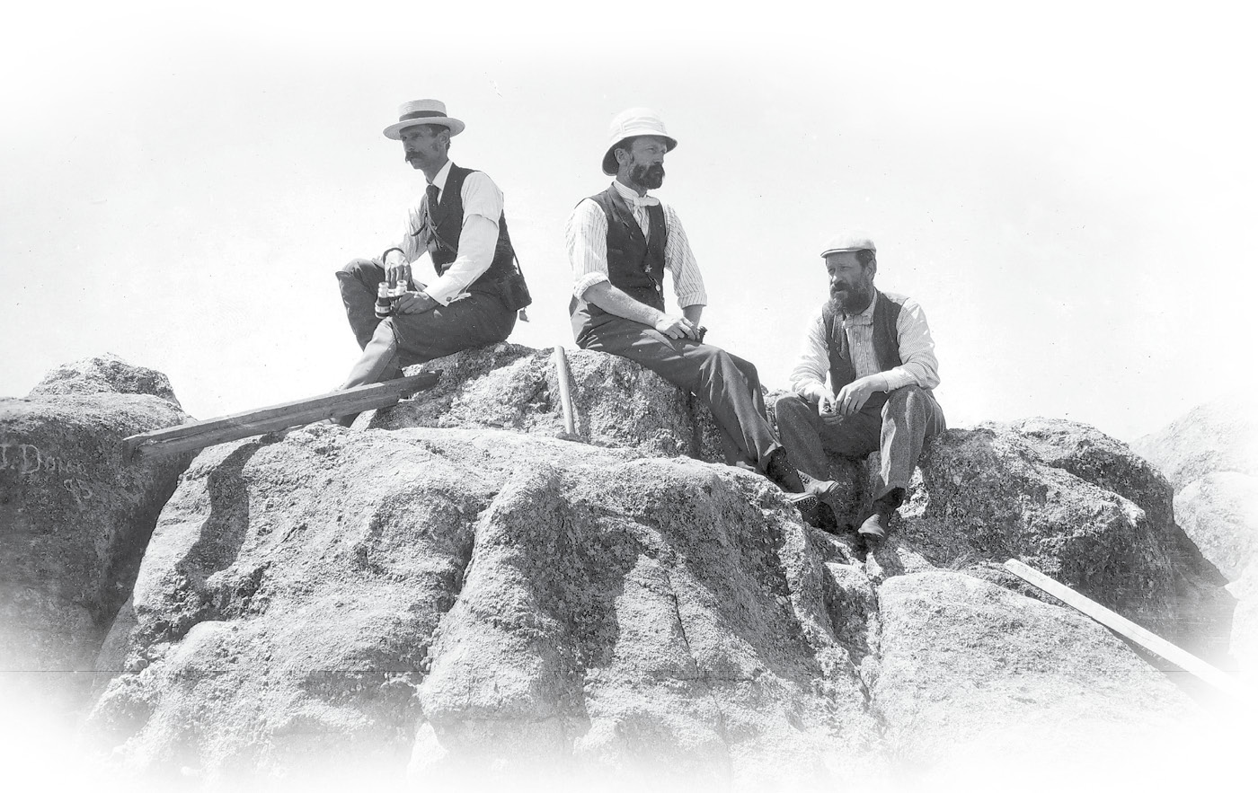
Atop the summit of Harney Peak, USGS personnel Joseph A. Holmes, Charles D. Walcott, and Henry Gannett rest upon one of the strategic points in the Black Hills triangulation network. Courtesy of the U. S. Geological Survey Photographic Library.
When the United States Geological Survey (USGS) became tasked with mapping the nation into one contiguous system based upon accurate latitude and longitude in the late 1800’s, they chose to begin in key and often isolated areas of the country that were of national importance. One region already prospering with mining and forestry interests was the Black Hills region of southwestern South Dakota. Existing maps within the area were generally compiled from assumed or local control, so the maps were generally not spatially correct, nor could they be interconnected together.
To begin the survey of the Black Hills, 29-year-old Samuel S. Gannett arrived in the area’s largest city Rapid City, during the fall of 1890. This talented geodetic surveyor was the cousin of famed Henry Gannett, a fellow USGS employee who was widely known as the father of government map making. The main objective for Gannett was to place an astronomical monument and then make the necessary observations to determine its precise latitude and longitude. With the assistance of Abner F. Dunnington, the two men constructed a brick pier in the courthouse lawn approximately 75 feet west of the southwest corner of the building. The pier was sunk 36 inches below the surface and extended 30 inches above. A dressed sandstone cap with a center point rested on top of the pier and was lettered U.S.G.S.
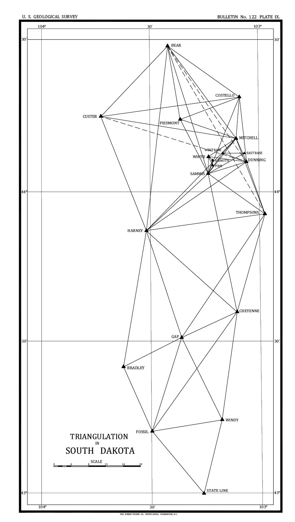
The initial triangulation network of the Black Hills of 1893 consisted of 20 points including an astronomical pier, meridian mark, and two baseline monuments.
The work to determine the position of the astronomical pier began on October 23, 1890, by taking repeated readings on stars to determine the latitude and by telegraph time signals with St. Louis to determine the longitude. Professor Henry S. Pritchett, an astronomer and educator at Washington University in St. Louis, coordinated the signals from the observatory at that location. Pritchett had earlier been the assistant astronomer at the U. S. Naval Observatory and later became the Superintendent of the U. S. Coast & Geodetic Survey from 1897-1900. The work was completed 28 days later on November 20. Another smaller monument was placed on the true meridian north of the courthouse at a log distance of 3.3108 meters (6711.03 feet) and became known as the meridian mark. The final position of the Astronomical Pier was determined to be 44°04’45.240” North Latitude and 103°12’59.283” West Longitude and became the beginning point for the Rapid City Datum.
The following season, 1891, USGS surveyor Charles H. Fitch came to Rapid City to establish a baseline for the upcoming triangulation network. The relatively flat area of Box Elder Creek located northeast of the city created an ideal place for the baseline, so a random location was chosen for the west end in a pasture approx. 3 ½ miles northeast of the courthouse. A natural rock outcropping was chosen for the east end of the baseline where a point was marked as the termination of the line. At both endpoints, the center points on the stones were marked with a “+” while two reference point stones were placed 25 feet perpendicular to the end points and a third reference stone was placed 25 feet on line. Each reference stone was marked “RP” along with an arrow pointing to the end points on the baseline. The locations for several of the triangulation stations were also selected in 1891 by William S. Post on prominent hills and key peaks.
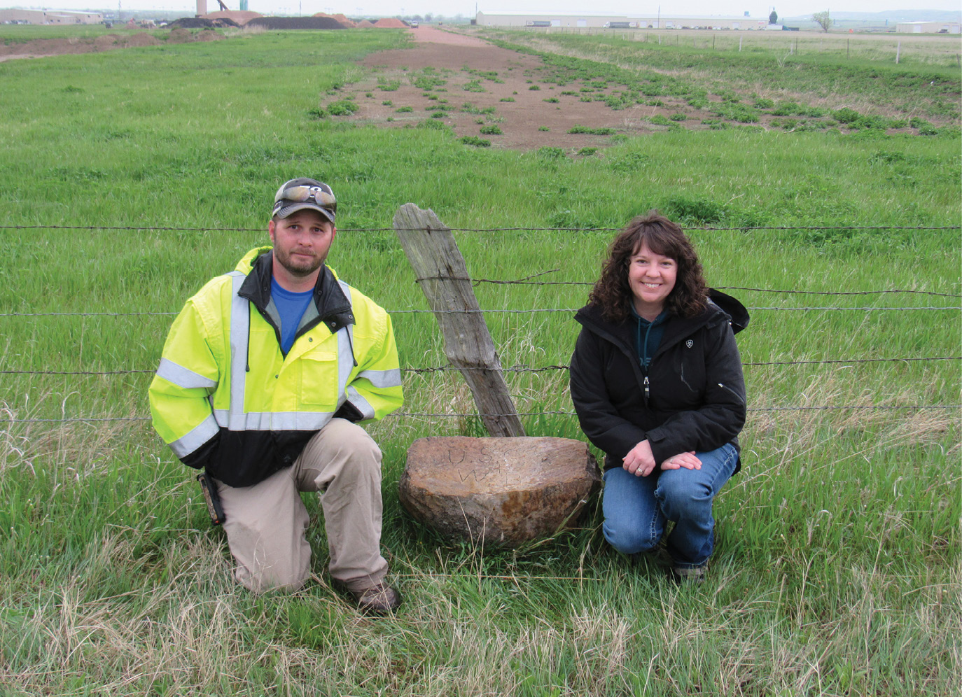
South Dakota licensed land surveyors Jon Collins and Linda Foster pose with the recovered “West Base” monument of the baseline that was established in 1891. The marked stone was found moved out of its original location and placed in a nearby fence. Jerry Penry photo
Due to commitments with similar projects in other areas of the country, no further work was done in the Black Hills during 1892. During the fall of 1893, the Rapid City Base Line was officially measured three separate times by Edward M. Douglas with a 300-foot steel tape while being supported at 50-foot intervals under a uniform tension of 20 pounds and with thermometer readings taken at both ends during each measurement. The final length of the baseline was determined to be 25,796.115 feet (4.886 miles) after making corrections for slope, temperature, and the reduction to sea level. The probable error of the three measurements was determined to be about seven-hundredths of a foot.
 In addition to the astronomical pier, meridian mark, and baseline points, another sixteen monuments were placed throughout the Black Hills region. Observations were taken by single and combined directions having the entire triangulation scheme divided into blocks of five stations each and adjusted by least squares. The stations consisted of low platforms constructed of lumber with a signal pole mounted in the center above with the tripod placed below so angles could be turned from another location if a point was being occupied.
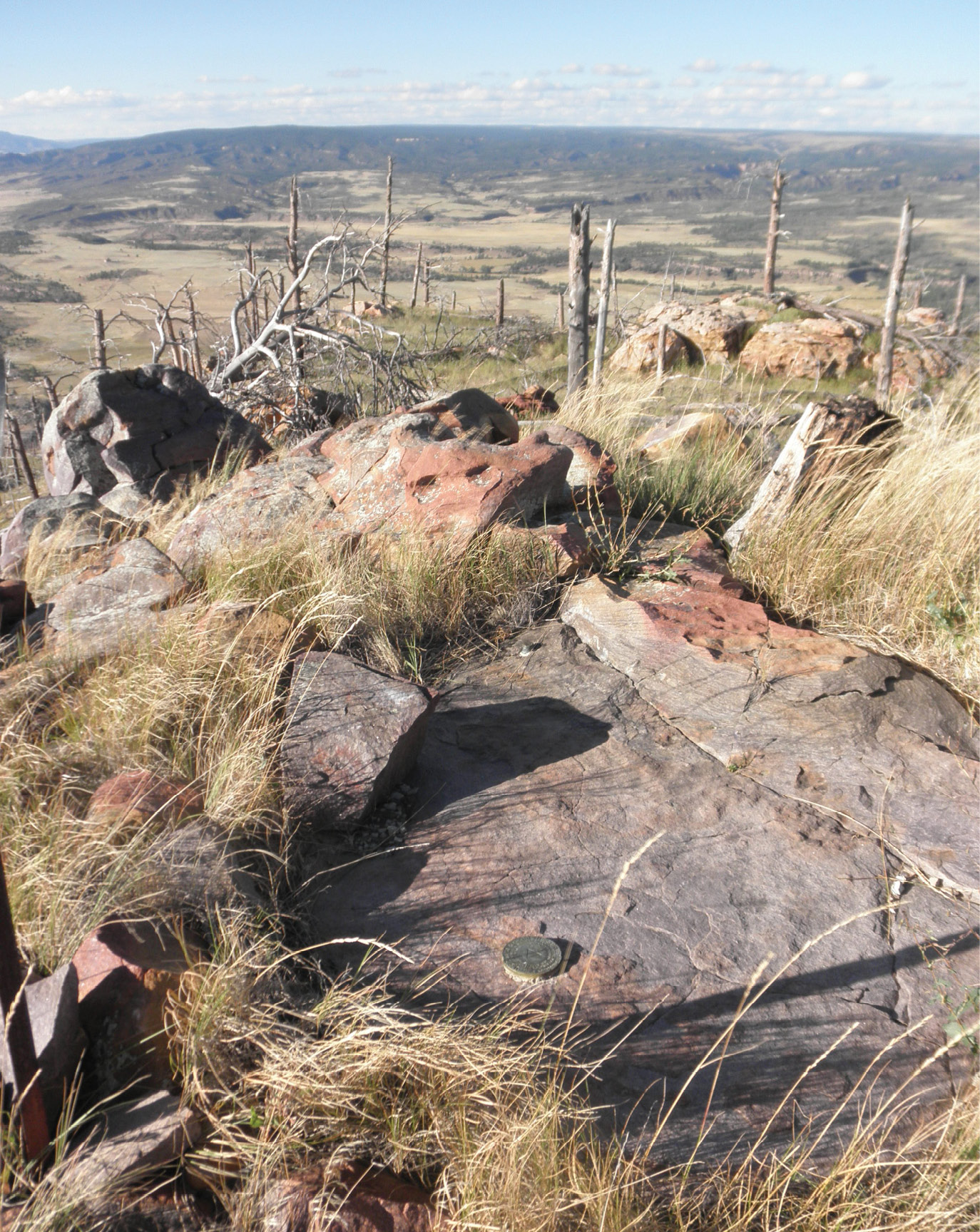
The initial triangulation network spanned a distance of about 102 miles north-south with the south end being near the Nebraska/South Dakota state line while the north end was placed upon Bear Butte located 6 miles northeast of the town of Sturgis. The width of the initial network was about 38 miles having the far west point upon Custer Peak and the easternmost point on a lone formation on the prairie known as Thompson Butte. Among the other points that were established was one upon the summit of the famed Harney Peak, the highest point in the region.
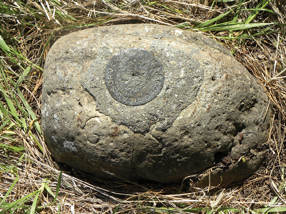
Triangulation station “Sammis” is one of the original monuments placed in 1893. The bronze disk was likely added during the reoccupation in 1897. The letters “G. S.” can be seen along the bottom edge. Jerry Penry photo
The triangulation monuments generally consisted of marked stones or iron and copper bolts drilled into rock. To test the accuracy of their latitude, USGS strategically placed their most southern point on a hill close to quartzite half-mile post 184 ½ that had been established that same year on the state line. This boundary between Nebraska and South Dakota had originally been marked with wooden stakes in 1874 and then resurveyed and remarked with the stone posts. Despite there having been several astronomical points placed along the state line to assist the contract surveyor of the General Land Office to mark the line as close to 43° North Latitude as possible in 1874, the USGS surveyors found this line to be nearly 4.5 seconds too far north.
Immediately after the triangulation network was established, and the final positions of the stations determined, the topographical mapping began of the Black Hills. In 1897, 1900, and 1904, USGS expanded their original triangulation by placing an additional 38 points that reached into Wyoming and also to the plains further north. It was not until 1912 that USC&GS entered the Black Hills to establish their own separate triangulation network. Instead of using and occupying the existing USGS monuments during their triangulation, USC&GS generally placed their own monument just a few feet away. USC&GS expanded their triangulation in the Black Hills in 1925 and again in 1950.
The copper bolt along the top edge of the flat rock was placed by USGS in 1897 and was designated station “Elk”. In 1912, USC&GS occupied the same peak, but placed their own bronze disk just a few feet away and also designated their monument as station “Elk” Kurt Luebke photo
Time has now taken its toll on many of the original monuments of the initial USGS triangulation network in that area. The astronomical pier at the courthouse was apparently removed in 1922 when a new building was constructed with the location now situated in an asphalt parking lot. The meridian mark is likewise destroyed and is now a church parking lot. The east end of the baseline was removed around 1961 when Interstate 90 was constructed. The west end of the baseline along with two of its reference points were found lying loose in a nearby fence in May 2019 not far from where they had been originally placed. Efforts are now being made to have the scribed West Base stone placed in a local museum. Points on Harney and Custer peaks were removed very early when fire lookout towers were built at those locations. The northern point on Bear Butte has succumbed to erosion due to the brittle limestone surface on which the scribing was placed. Others, however, such as marked stones at Windy, Costello, Sammis and Cheyenne are still in place. The latter two had bronze disks placed into them during their reoccupation in subsequent surveys.
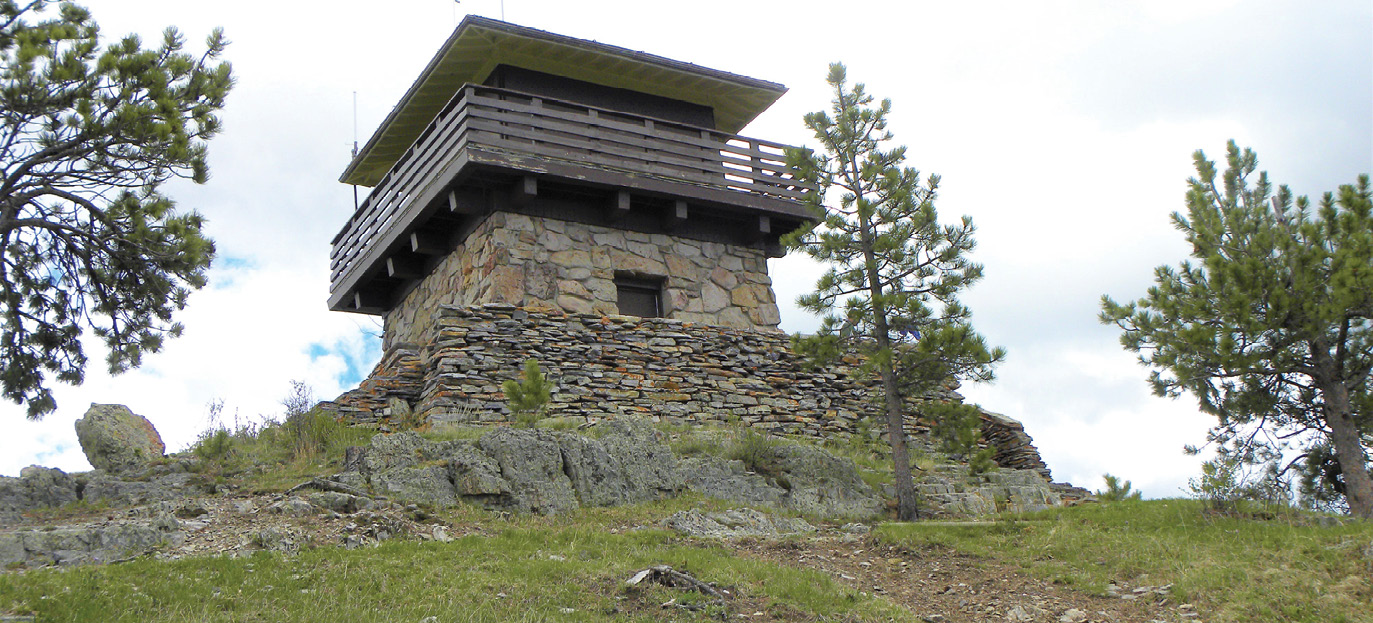
Fire lookout towers were later placed on many of the same prominent peaks of the Black Hills where the triangulation stations were located. The construction of this tower on Custer Peak destroyed the 1893 monument. Jerry Penry photo
Since the original horizontal survey by USGS within the Black Hills was a stand-alone network, it was often referred to as the Rapid City Datum. The vertical aspect of the survey was also unique to the Black Hills and was referenced to a railroad bench mark at Deadwood and was known as the Deadwood Datum. (See The American Surveyor Vol. 9, Issue 7). The objective was to eventually cover an area bounded by 43° to 45° North Latitude by 103° to 104°-30’ West Longitude. The end result of this early establishment of precise control was the publishing of eleven 30-minute (1:125000) and five 15-minute (1:62500) quad sheets showing contiguous detail never known before in that region of the country.
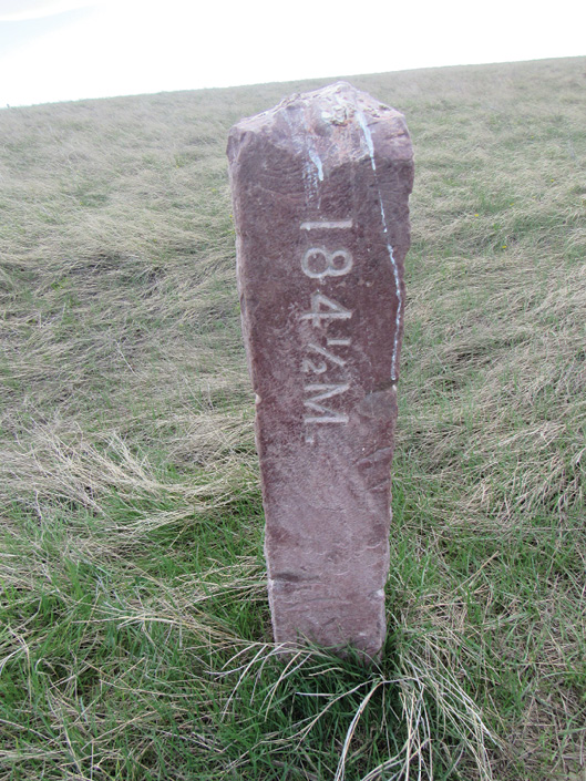
This boundary milepost on the NE/SD state line was placed by the GLO in 1893. USGS placed their most southern triangulation station nearby during the same year to tie into it to check the position of 43°00’00” North Latitude. The milepost monument was found to be 4.5 seconds too far north. Jerry Penry photo
The National Geodetic Survey currently maintains positions and datasheets on four of the original points. The difference in positions when comparing the NAD83(1996) positions to the historical positions of the Rapid City Datum is an average of 2.15 seconds less in latitude and an average of 24.81 seconds more in longitude.
Into the early 1900’s, USGS continued to maintain a visible presence in the Black Hills by surveying several key boundaries such as the extensive Black Hills National Forest boundary, the Wind Cave National Park boundary, and establishing and subdividing many townships while doing PLSS work within the area controlled by the Black Hills Meridian. The establishment of capped iron pipes at township corners by USGS within the Black Hills in the late 1890’s was more than a decade before the GLO issued the use of iron monuments for their use in the 1909 Manual of Instructions. Widely known as primarily a mapping agency, USGS once employed some of the most competent geodetic and boundary surveyors this nation has known.