 Leicestershire, UK, 25 November 2019 – Treeconomics, a specialist in the use of trees to improve urban spaces, is taking advantage of a digital record of over 300 million trees created by aerial mapping company Bluesky. In a landmark project for the London Borough of Islington, Treeconomics completed a study to measure and assess tree canopy cover and understand its impact on the urban environment.
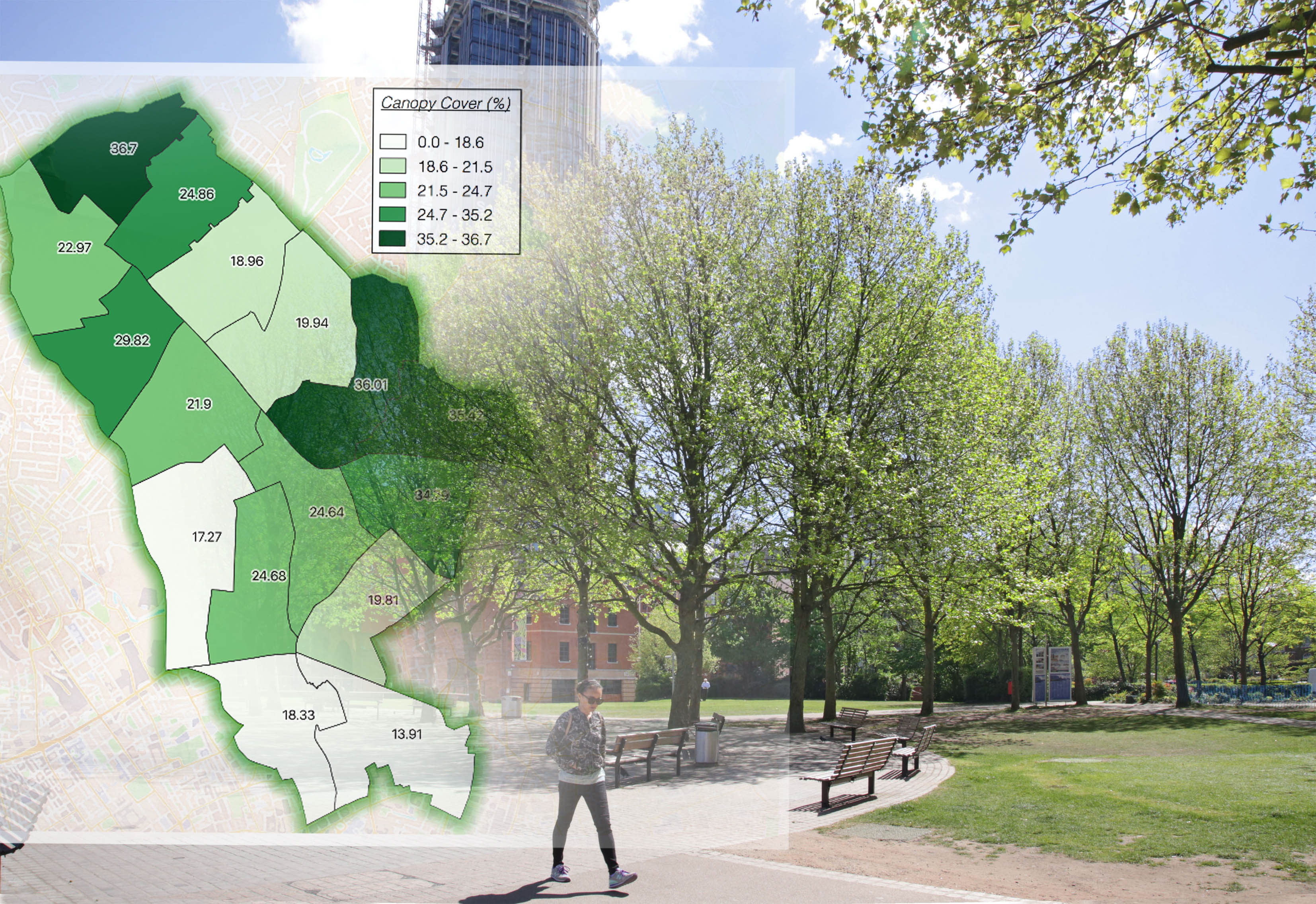
The Bluesky National Tree Map was used in conjunction with a variety of open datasets including health and socio-economic data from organisations such as the Office of National Statistics and Public Health England. Following advanced geospatial analysis, Treeconomics were able to identify a link between higher canopy cover and increased life expectancy, lower crime rates and higher house prices.
Treeconomics also produced a tree plant strategy for Islington Council and concluded the inner London Borough could reasonably aspire to increase canopy cover in alignment with London’s target to achieve 30% tree cover by 2050.
“Trees are arguably the most important component of Green Infrastructure, yet are often overlooked and undervalued,” commented Kenton Rogers, co-founder of Treeconomics. “In particular, trees are important because they enhance and improve the urban environment by providing a wide range of benefits at relatively little cost. For example, there is a growing body of research which demonstrates that trees improve our health and well-being, provide a ‘sense of place’, moderate extremes of temperature in urban areas, improve air quality and act as a carbon sink.
“Using the Bluesky National Tree Map data, in conjunction with relevant statistics and software for forestry analysis and benefit assessment, we can help organisations such as the London Borough of Islington understand their current green asset and plan for the future,” he concluded.
The Bluesky National Tree Map is the most detailed dataset of its kind ever produced. With coverage across the whole of England and Wales, the National Tree Map provides a unique, comprehensive database of location, height and canopy/crown extents for trees 3m and above in height.
Using the Bluesky National Tree Map data, Treeconomics concluded the overall canopy cover for the borough of Islington was estimated at 25 percent. This favourably compares to a national average estimated in 320 towns and cities of 17 percent and a London-wide estimate of 21%. Treeconomics also suggested that Islington could aspire to a canopy cover of 30%, identified areas of low canopy cover and potential ‘plantable’ spaces.
About Bluesky
Bluesky is one of the leading and most successful aerial survey and geographic data companies in the UK producing and maintaining seamless digital aerial photography and height data on a national scale in both Great Britain and the Republic of Ireland. Bluesky operates the worlds most advanced airborne sensor, which comprises vertical and oblique cameras as well as a LiDAR, to create accurate and detailed virtual cities. Bluesky also operates the only LiDAR system in the world that incorporates a thermal sensor and survey grade camera. These combined with other systems puts Bluesky in the enviable position of being able to provide customers with unique and cost-effective geospatial solutions. As well as being an established and respected aerial survey company Bluesky is also highly innovative and continually strives to develop new products and services by embracing new technology and methods. This has resulted in the development of some unique products such as the National Tree Map (NTM). These datasets underpin long term contracts with local and central governments and many major blue-chip companies from a range of market sectors including financial services, utilities, telecoms, web portals, construction and environment. Bluesky has offices in the UK, US, Republic of Ireland and a dedicated production centre in India. https://www.bluesky-world.com/
About Treeconomics
Treeconomicsworks internationally with community groups, research organisations, public bodies, municipalities and private business to complete projects which highlight the value of trees. Treeconomics uses a variety of different assessment tools and methods, including the most widely used i-Tree Eco model. This is a peer reviewed, open source package, piloted in the UK with project partners and development is ongoing. Treeconomics Limited is a social enterprise, an organisation that applies commercial strategies to maximise improvements in human and environmental wellbeing, rather than maximising profits for external shareholders. https://www.treeconomics.co.uk/
