Septentrio Post-Processing Kinematic (PPK) software has been upgraded with multi-GNSS and BaseFinder functionality. BaseFinder improves project efficiency by automatically finding the most suitable reference station data needed for centimeter-level accuracy.
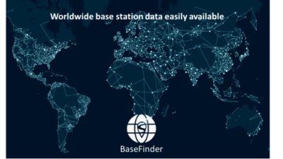
 Leuven, Belgium – November X, 2019 – Septentrio, a leading manufacturer of accurate and reliable GPS technology, has released a key upgrade for their GPS post-processing software. Both GeoTagZ and PP-SDK now feature BaseFinder, a tool that speeds up survey workflow by automatically finding reference data needed for augmenting GNSS* logs with sub-centimeter accuracy. BaseFinder accesses an online database of reference networks and extracts the most suitable corrections available. BaseFinder is available via an App or via an API and can be incorporated into any existing software.
*GNSS: Global Navigation Satellite System such as the American GPS, European Galileo, Russian GLONASS, and Chinese BeiDou. These satellite constellations broadcast positioning information to receivers which use it to calculate their absolute position.
Septentrio has two decades of experience delivering reliable and robust RTK and PPK sub-centimeter positioning to industrial applications. PPK is often used for ground surveys with aerial drones, allowing high precision georeferencing without the need for a real-time base station link or ground control points (GCPs).

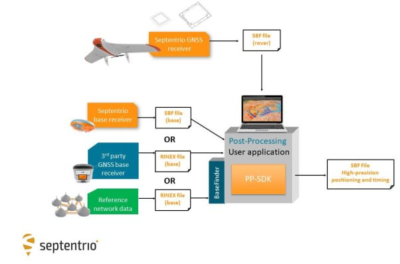
GPS Post-Processing SDK architecture, bringing high-accuracy positioning without the need for a real-time correction stream.
“Surveying without a base station will allow users to reduce costs and set-up time. With this PPK upgrade we are improving the end-user experience as well as developer experience,” commented Danilo Sabbatini, Product Manager at Septentrio.
The new release of this GNSS post-processing software also includes two additional GNSS constellations: European Galileo and Chinese BeiDou. Having access to all the signals from all GNSS constellations improves reference network compatibility. It also improves positioning availability in difficult environments. This is particularly important when working in areas of low satellite visibility such as near tall structures or under foliage.
When doing photogrammetry with a drone, GNSS data is often recorded and then post-processed together with base station data to achieve sub-centimeter positioning accuracy. This base station data can be obtained either with proprietary base stations or by using base station data from a public reference network (see diagram below). Septentrio receivers are designed to bring accurate and reliable positioning to photogrammetry, aerial inspection, marine survey as well as mobile mapping.
About Septentrio
Septentrio provides high-precision, multi-frequency, multi-constellation GPS/GNSS positioning technology for demanding applications. Reliable centimeter-level positioning enables machine autonomy, provides operational continuity and ensures safety-of-life. Septentrio provides positioning solutions for professional applications in industries such as robotics and automation, construction, survey and mapping, marine, logistics and unmanned aerial vehicles (UAVs). Septentrio has its headquarters in Leuven, Belgium and has a world-wide presence with offices in Los Angeles, Shanghai and Yokohama as well as numerous partners around the world. To learn more about Septentrio and its products, visit septentrio.com.
For more info:
PP-SDK – Septentrio’s Post Processing Kinematic (PPK) software to achieve reliable centimeter-level positioning by post-processing GNSS and base station data.
GeoTagZ – Geotagging and GNSS data post-processing software to achieve centimeter-level RTK ground precision from aerial survey.
Related insight articles:
UAV mapping without Ground Control Points (GCPs)
Look, no Ground Control Points!
