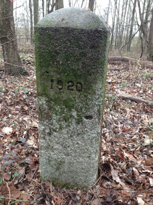
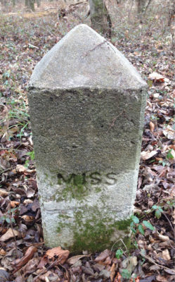
Arkansas/Mississippi Boundary Monument 3 and Reference Monument 2.
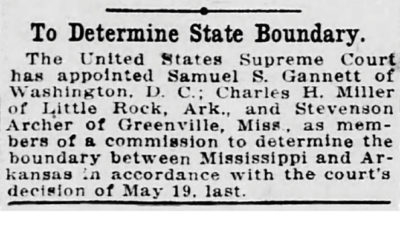
Port Royal was once the county seat in Coahoma County, Mississippi. It was a bustling little town along the banks of the Mississippi River and an important stop for Steamboats1. This all changed however when the mighty river decided to cutoff nearly nine miles of oxbow and overnight make a river town into ghost town and a land locked one at that. Friars Point became the new county seat as it still had river access and was unaffected by the recent ravages of the Mississippi River. This cutoff, known today as Horseshoe Cutoff, sealed off a portion of Arkansas from the mainland and left behind a beautiful oxbow lake justly called Horseshoe Lake. The land and its rights, within the oxbow, were one of confusion though and during March of 1919 the Supreme Court heard the arguments of both states and made a decision a mere couple weeks thereafter. The highest court stated that “The location and determination of such boundary is a matter which we shall leave in the first instance to a commission of three competent persons to be named by the court…”2 These three men were Charles H. Miller, Stevenson Archer, Jr. and the State Line Boundary Retracement Specialist himself – Samuel Stinson Gannett.
 The Mississippi River is the second longest river in the United States, followed by its leading tributary the Missouri River. At its beginning in Lake Itasca in northern Minnesota, it is a mere twenty feet wide and at its widest, also in Minnesota in Lake Winnibigoshish, it spans eleven miles wide. The Muddy Mississippi, as it is commonly called, eventually flows over 2,000 miles to the Gulf of Mexico averaging a navigable channel from half a mile to two miles wide. If the Mississippi, the Missouri and the Ohio were tallied together it could be the third longest river system in the world. The amount of water the Mississippi discharges ranks it as the 15th largest river in the world, the first being the Amazon3. With all this water and force, sometimes the river decides to make a new course. Similar to the story of McKissick’s Island of 1867 and the forceful act of avulsion on the Missouri River, this event happened around 1848 and was on the Mississippi River separating the states of Arkansas and Mississippi4.
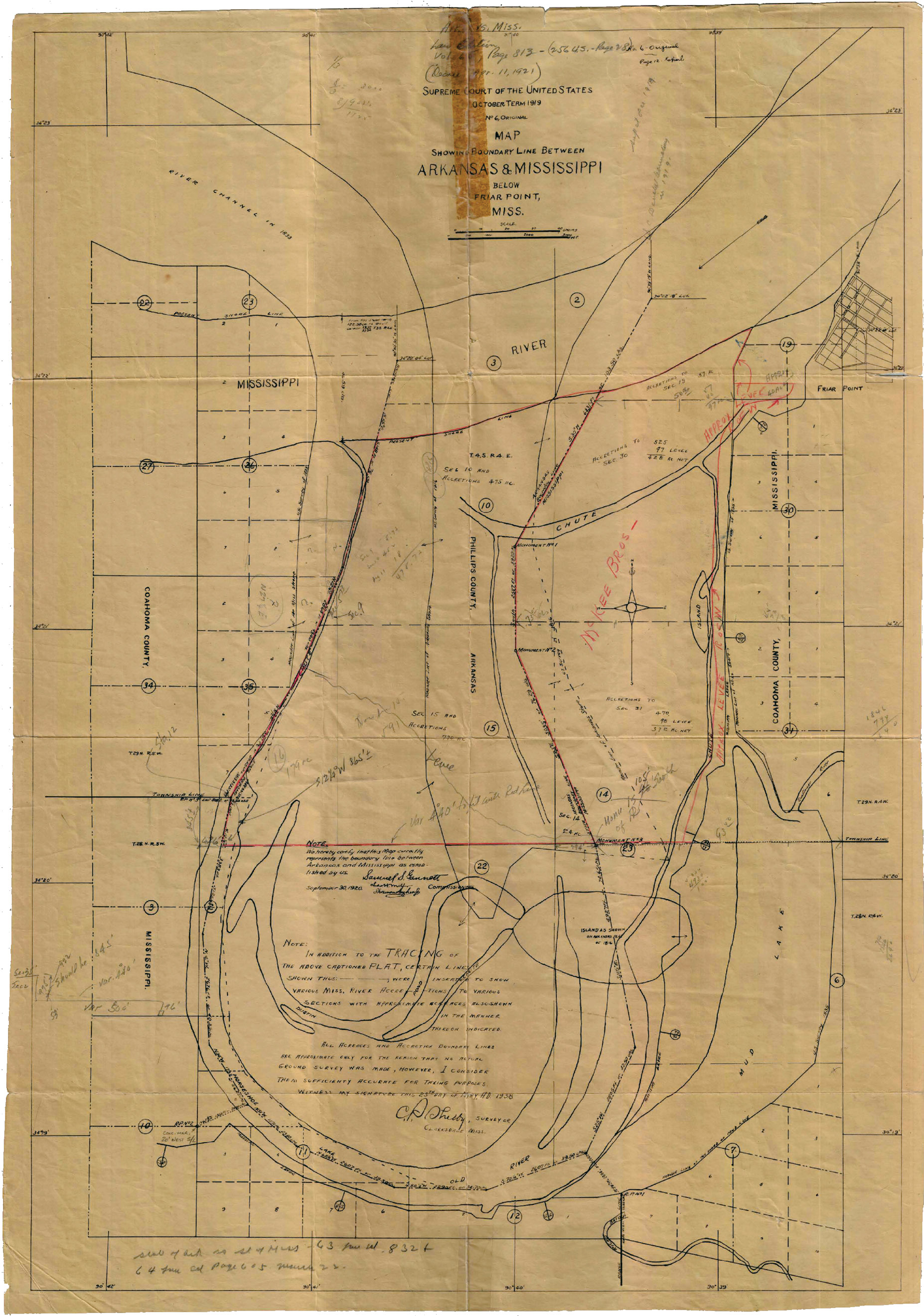
“Map showing the boundary line between Arkansas and Mississippi below Friar Point, Miss.” Courtesy of Terry Smith, PS
The State of Mississippi became the 20th State on December 10, 1817. According to the Mississippi Constitution of 1817, the potion of the boundary in discussion runs “…thence West along the said degree of latitude to the Mississippi River, thence up the same to the beginning…” The General land Office (GLO) surveyed the area surrounding Horseshoe Lake from 1831 – 1835. This comprises Town 28 & 29 North and Range 4 & 5 West of the Choctaw Meridian and Baseline. The State of Arkansas became the 25th State on June 15, 1836. According to the Constitution of the State of Arkansas of 1874, the portion of the boundary in discussion runs “…to the middle of the main channel of the Mississippi River; thence up the middle of the main channel of said last-named river, including an island in said river known as “Belle Point Island,” and all other land originally surveyed and included as a part of the Territory or State of Arkansas, to the thirty-sixth degree of north latitude…”. The GLO surveyed the area surrounding Horseshoe Lake in 1816. This comprises Town 3 & 4 South and Range 4 & 5 East of the Arkansas 5th Principal Meridian and Baseline. This Principal Meridian controls all lands of the Louisiana Purchase and comprises 6 different States and ultimately ending at the Northwest Corner of North Dakota5.
 The Supreme Court relied on the recent case of Arkansas v. Tennessee, 246 U.S. 158 from 1918 of which relied on the more historic case of Iowa v. Illinois, 147 U.S. 1 from 1893. Both cases implement the “Thalweg Doctrine” and remind us of the very similar survey Gannett performed on the frozen St. Louis River in January of 19206. The two commissioners, alongside Gannett, were chosen clearly for their knowledge of the Mississippi River. Charles H. Miller was the president of the Miller-Butterworth Company of which he founded alongside A.C. Butterworth in 1911. He was a man with major knowledge of the river as for 13 years he worked for the Corps of Engineers on the Mississippi River and was also an expert witness in over 35 cases including the Red River between Oklahoma and Texas7. Stevenson Archer worked under Charles H. Miller while in the Corps and was highly regarded in his field. The combination of these three no doubt led to the successful completion of this disputed state line. Due to high water the survey crew did not commence work immediately, but instead spent time studying old maps and records to prepare themselves for the survey ahead.

Seven different GLO maps georeferenced to show the original oxbow with the assistance of GIS specialist Chaz Burkhart. Courtesy of General Land Office Records
They met on August 4, 1920 at Friars Point and continued to study the maps as well as evidence in the field. The commission made notes of what they found of the old river bed and stated “…being totally devoid of short and irregular bends and following a generally uniform curve of radius similar to that of the original river in this vicinity, was, without a doubt formed by the main river, and a great difference in the age of the timber on the west bank as compared with the age of that on the east bank shows that the west bank of this ‘slough’ marked the most westerly limit of the main river at the time of the avulsion”8. They continued with their inspection of where the original river existed then they went about setting monuments and taking precise measurements and eventually preparing their plat and report for the Supreme Court. The monuments existed of points set on line and reference monuments as it was not possible to mark the state line in Horseshoe Lake. The state line monuments were made of timber reinforced concrete 12 inches square and 36 inches high seated on a concrete cube of 24 inches. These were marked “ARK” on the West side, “MISS” on the East side, “1920” on the North side and the monument number on the South side. The reference monuments consisted of concrete monuments and iron posts 6 feet long and 2 inches in diameter set 3 feet in the ground. All monuments were then witnesses off to nearby bearing trees. This was not being the largest survey by Gannett as it only consisted of 3 state line monuments and 3 reference monuments. The plat shows the state line with bearing and distances in both feet and chains, and starts and ends in the middle of the Mississippi River with an approximate latitude and longitude.
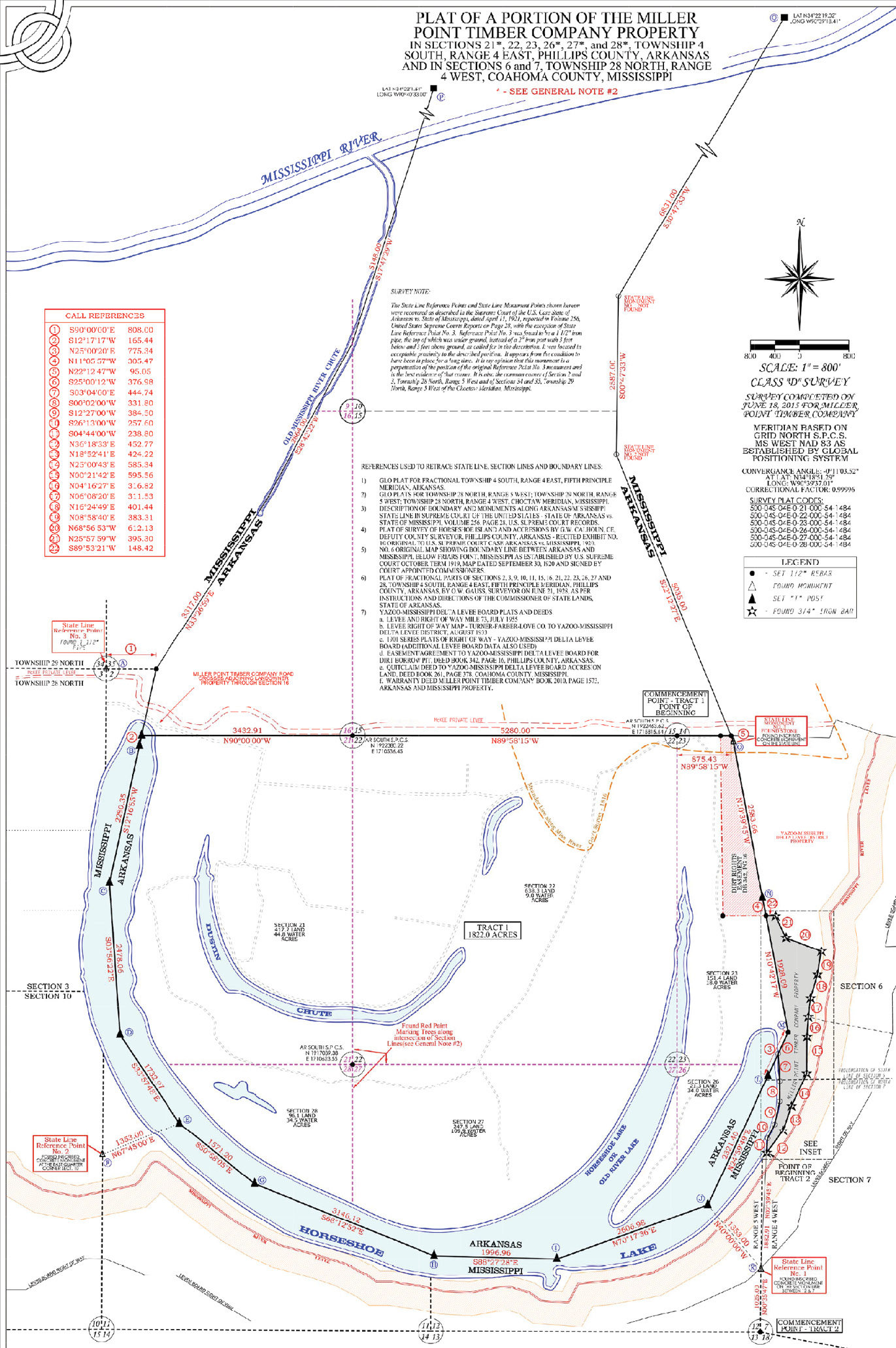
“Plat of a Portion of the Miller Point Timber Company Property” Courtesy of Terry Smith, PS
The seven maps that comprise the various GLO surveys were studied, analyzed and georeferenced to compare it to the original plat by Gannett. Utilizing ArcGIS ArcMap 10.6.1 the maps meshed together amazingly well with little distortion or scaling. Furthermore I was provided a survey by Arkansas and Mississippi Professional Land Surveyor Terry Smith. Terry retraced this area in discussion in June of 2015 and did so with the utmost detail, precision and accuracy, not to mention pure art. Without the info from Terry I would not have been able to accurately georeference the maps as they comprised two separate GLO surveys with the Mississippi River in between.
In the end, like every survey Gannett has worked on for the Supreme Court, it was “…declared and decreed to be the true boundary line between the States of Arkansas and Mississippi…” and once again put an end to a dispute between two States. And although it may look odd, if you are on Horseshoe Lake, you are indeed spanning the State line between Arkansas and Mississippi and ultimately looking at the boundary as secured by the Treaty of Peace between the United States and Great Britain in 1783.
Next we will travel back to 1910 when Gannett was an expert witness for the Supreme Court for the dispute on the ridge top between North Carolina and Tennessee. Even though he was no part of the official Supreme Court survey, his opinion was highly sought after for a successful determination of this disputed State line.
1 Riley, Franklin L. Publications of the Mississippi Historical Society. Oxford, Mississippi, 1902.
2 Day, William Rufus, and Supreme Court of the United States. U.S. Reports: Arkansas v. Mississippi, 250 U.S. 39. 1918. Periodical. https://www.loc.gov/item/usrep250039/.
3 National Park Service. https://www.nps.gov/miss/riverfacts.htm. December 31, 2018.
4 Penry, Jerry. “A Tale of Fateful Survey: McKissick’s Island.” American Surveyor Magazine. May 2018.
5 Elgin, Richard. “The Initial Point of the 5th Principal Meridian.” American Surveyor Magazine. April 2015.
6 Fenicle, Joseph. “Unsung Hero: The Wisconsin-Minnesota State Line.” American Surveyor Magazine, August 2018.
7 “Who’s Who in Construction.” The Constructor, Volume 4, Number 8, August 1922, Page 19.
8 Day, William Rufus, and Supreme Court of the United States. U.S. Reports: Arkansas v. Mississippi, 256 U.S. 28. 1920. Periodical. https://www.loc.gov/item/usrep256028/.