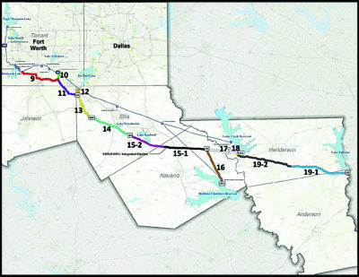
Map of the Integrated Pipeline Project, the largest water transmission system of its kind in the state.
Sometimes a project comes along that changes everything. For the Tarrant Regional Water District (TRWD), in Fort Worth, Texas, that project was the Integrated Pipeline Project (IPL), the largest water transmission system of its kind in the state.
Built in partnership with the City of Dallas Water Utilities (DWU), the IPL will consist of 150 miles of pipeline, three new lake pump stations, and three new booster pump stations built to deliver a required capacity of 350 million gallons per day (MGD) of raw water to North Central Texas.
Although pipelines, reservoirs and floodways have been a natural part of TRWD’s business for 90 years, the IPL would redefine business as usual—particularly for the geospatial services group.
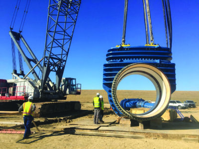
A pipeline component hangs at the ready. When phase one of the IPL is finished in Spring 2019, crews will have laid 70 miles of 84-inch to 108-in pipeline.
In the past, the group required extensive time to integrate accurate as-built data from pipeline construction projects into their water transmission GIS model. Given the scope of the IPL, they wanted to be able to collect and integrate survey-grade as-built data into their central GIS in near real time to enable crews, managers and stakeholders to monitor multiple pockets of construction, identify any issues that arose and immediately respond to them. The issue was how to do it.
“We had the high-precision survey technology and we had the GIS,” adds Mark McGuire, manager of TRWD’s geospatial services group. “We knew they wouldn’t be the problem. The bottleneck was the real-time interoperability.”
However, by connecting a bit of ingenuity with creative customization, TRWD broke through its information bottleneck with the development of its real-time as-built program (RTAB). A deceptively simple solution to a complex problem, the RTAB not only integrates survey data into TRWD’s GIS in real time, it parallels the field activities outside so managers inside can monitor construction as it’s happening, ensuring both the horizontal and vertical accuracy of the assets being placed and the real-time responsiveness to any issues needing attention. Four years into the IPL construction, the new system is providing a perspective they’ve never had before, a level of information they’ve never had before, and it’s changing the business of pipeline construction for them.
What If…
RTAB started from a spontaneous question that was a little radical at the time. It was 2010 and managers were highlighting the need for more efficient data processing and sharing of GIS-based construction information. They needed to ensure all infrastructure assets were being placed according to design specifications, and with the magnitude of the IPL, they couldn’t afford even a single day delay in as-built data. That’s when Eddie Weaver, TRWD’s IPL deputy program director, asked, “What if we could get the as-built survey data into the enterprise GIS in real time?”
“Historically, as-builts have been an afterthought on construction projects,” says Weaver. “They often weren’t collected, and if they were, they were hand-drawn on paper and weren’t always accurate or complete. But as-built data is critical to ensuring quality control on the IPL design and for giving us a detailed inventory of our installed assets. That made me wonder, ‘Can we develop the technical capability to collect as-built data ourselves, and tie it in to our existing GIS and asset management systems, to give us a real-time record of what we installed, where it was installed and when it was installed?’.”
No one had an immediate answer.
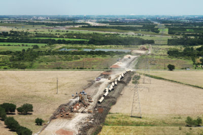
The IPL will consist of 150 miles of pipeline, three new lake pump stations, and three new booster pump stations. It will deliver a required capacity of 350 million gallons per day of raw water to North Central Texas.
At the time, they were not familiar with any technological options for that kind of seamless, real-time interoperability. And they knew of very few, if any, organizations that were routinely integrating high-precision as-built information into their GIS.
Initially they focused on assembling the survey technology that would meet their high-accuracy data requirements. As long-term users of Trimble technology, they chose a collection of Trimble® R8 and R8s GNSS receivers to acquire Real-Time-Kinematic (RTK) survey data and a set of Trimble Yuma® 2 rugged tablets to store and export the field data. The Yuma tablets would be particularly beneficial because they offer Trimble Access™ survey field software, a user-friendly operating system and mobile communication technology.
In addition, the geospatial services group created and set up for each data collector a detailed data dictionary template for acquiring 30 pipeline assets and attributes and outfitted all crews with a standard operating procedure (SOP) document that clearly instructs what features to collect and how to collect them. Standardizing the survey process with uniform hardware and software, a data dictionary and an SOP ensured teams would collect all required IPL assets at the required sub-decimeter accuracy and reduce user error.
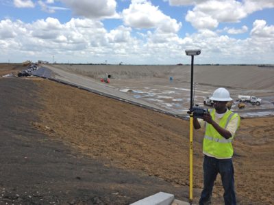
Rich Haynes, a pipeline resident representative with TRWD, uses a Trimble R8 GNSS unit and a Trimble Yuma 2 tablet to collect as-built measurements of an installed conduit for the IPL project. With RTAB, that data is available in near real-time back in the office.
With the survey and GIS elements set, TRWD focused on the most challenging piece: finding a solution to bring the GNSS data automatically into their Esri® Enterprise GIS. In 2013, TRWD gave that puzzle to engineering consulting firm Halff Associates to solve.
Halff, based in Richardson, Tex., first capitalized on the existing mobile technology of the Yuma tablet and installed a cloud-based file sharing software. With this approach, crews could transfer the field data to the office via a cellular connection. The Halff team also took advantage of Esri ArcGIS Server’s REST services, which allowed them to create the Web-based framework to automatically process and move the Trimble survey data into the GIS. From there, they developed a customized “listener” tool that would detect new IPL-related files uploaded to the cloud, quickly analyze them and using the pre-defined ArcGIS REST services, automatically move the information into the correct data layers and attribute fields in the GIS.
Readied for the field in January 2014, the RTAB program would run on a combination of seven Trimble R8s and R8 receivers and Yuma tablets for the IPL project.
“For the IPL, we’ll have 150 miles of pipeline, 99 percent of which will be underground,” says McGuire. “Our survey technology provides the precise as-built data we need and the RTAB program ensures that we can monitor and verify that every pipeline segment and asset is being placed according to the design in near real time. In terms of efficiency and potential cost savings, that is priceless.”
As-builts in real time
The IPL is being constructed in five distinct phases. Phase one construction began in May 2014 and was completed in the spring of 2019. Crews laid 70 miles of 84-inch to 108-in pipeline, built a 350 MGD booster pump station and constructed a 450-MG balancing reservoir and ancillary facilities. When the entire IPL is built, it will give DWU and TRWD an added 350 MGD of water supply to serve both its nearly 4.5 million existing customers and to meet the estimated population growth of the region.
Since phase one began five years ago, TRWD field teams have been collecting sub-decimeter horizontal and elevation data of features as crews build the required infrastructure. Although the need for survey-grade as-builts has depended on construction, at least two TRWD teams have been routinely on site for pipeline construction, with up to nine crews at peak times.
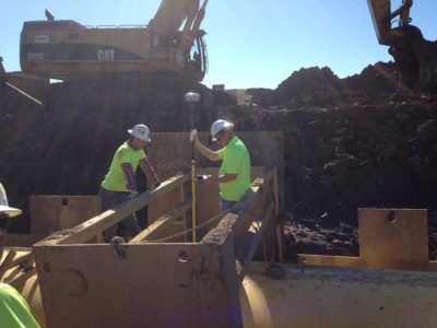
With the Trimble R8 and R8s receivers, crews use a combination of Trimble VRS (Virtual Reference Stations) technology, hosted by AllTerra, to provide RTK GNSS corrections to meet their sub-decimeter accuracy requirements. As each pipe segment is set, TRWD pipeline inspectors follow the specific SOP to collect all required asset and attribute data such as pipe-segment joints, valves, centers of manways and pipeline centerlines. Once a pipeline section has been buried, teams return to collect as-builts of surface feature assets like fences and crossings.
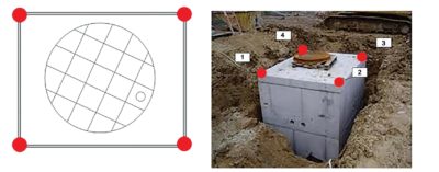
TRWD’s geospatial services group outfitted all crews with a standard operating procedure document that clearly instructs what features to collect and how to collect them. This diagram details what data points to collect on a fiber vault.
“Typically we only have a half-day or a one-day window before a pipe segment is buried,” says McGuire. “With this real-time system, we can determine immediately if a pipeline alignment is deviating from engineered plans, or if assets are not located in the original design locations. We can then alert crews to the error and rapidly ‘course-correct,’ saving the project from wasteful downtime and the unnecessary redo of pipeline construction.”
Once the pipeline assets have been acquired, the team uses the Yuma tablet’s Trimble Access software to export their data as a standard CSV file to the cloud. When the RTAB listener tool detects the new file, it parses it and automatically distributes the information into the relevant IPL datasets in TRWD’s GIS. Personnel in the geospatial services group then review and verify the accuracy of the newly acquired data, either flagging it for further review or accepting it and making it available for immediate viewing across the organization. To date, TRWD teams have collected nearly 22,153 data points on the IPL project.
“The moment we hit that sync button, the data is live and available to us and all the stakeholders so key decisions can be made in real time,” says McGuire. “In the past, it would take days to weeks to integrate our survey and GIS data, delaying our ability to make informed decisions. Now we can look at it live across multiple devices. It’s completely transformed our work patterns on the IPL and has begun to change how we support other divisions across TRWD.”
Indeed, based on the success of the RTAB system during phase one of the IPL, TRWD will continue to use its survey technology and RTAB for phase two construction, which will begin in early 2020 and aims to add 40 more miles of pipeline to the IPL.
In addition to the IPL, TRWD has expanded the program to support traditional and real-time surveying efforts including flood-control management, existing pipeline infrastructure, floodways and utilities. And it completed an internal pipe-data collection project. Teams collected around 600 features (manways, valves, and a point at each pipe segment) of about 7 miles of continuous pipe using the Trimble SX10.
Similar to the IPL process, geospatial services staff use Trimble SX10 and R8s GNSS units with Yuma tablets to collect a host of location and as-built data on critical infrastructure assets. They then export the data in real-time and the RTAB listener identifies to which particular project the data corresponds and populates the relevant GIS datasets in the enterprise GIS.
According to Rachel Ickert, TRWD’s water resources engineering director, the geospatial services group has used this data to develop a GIS-based hydraulics model, incorporating elevations of pressure readings and meters to allow them to better calibrate real-world field information with their planning models.
In addition to the significant operational benefits TRWD is gleaning from seamlessly linking the as-built data to its existing GIS, the integration of the RTAB program into TRWD’s asset management system (AMS) is also providing levels of insight and management opportunities that they’ve never had before.
“Connecting RTAB with our AMS is so powerful,” says Wesley Cleveland, TRWD’s integrated pipeline director. “Because we collect so much attribute data we can better monitor and maintain assets as they degrade or if something breaks down. Now our field guys can accurately navigate to an asset in the field, access the system, isolate the specific asset in question and have all the relevant attribute data in seconds. Once they’ve completed their work, they can capture an as-built, update any relevant attribute data and it’s immediately saved to both the GIS and AMS. This is far and away better than our paper drawings of the past. We will be using this system on anything we put in the ground.”
It appears then that the “integrated” part of the IPL is not only integrating infrastructure to keep sufficient water flowing to residents, it has helped bring data integration to TRWD in a completely new way. Fostering real-time monitoring, reporting, accountability and decision-making, TRWD’s RTAB is creating a geospatial data pipeline across its organization that is as fluid as the water it provides. In McGuire’s words, that is priceless.
Mary Jo Wagner is a freelance writer who has covered the geospatial industry for 25 years. Email: mj_wagner@shaw.ca.

