 I want to thank Jim Hankins for steering the ship with his feedback. He offers his thoughts from the dominant perspective in this case. The majority in Kandlik reinforces our need to have a better understanding of acquiescence. Hankins’ home state of Illinois encourages the surveyor to assist owners with mediation. Some do and some don’t. For the record I equate the surveyor as the first responder on the scene of the incident. This at the least puts us in a position to resuscitate the organs and triage wounds. Hankins reinforces the concept. Jim’s thoughts on Kandlik are as follows.
• • •
Jason,
I really enjoyed your article on Kandlik v. Hudek, and thank you for the kind words. One thing that I would like to point out in the Barbershop is the fence. Although you hit the nail on the head that the majority found the fence to be the boundary because of acquiescence instead of because the original grantors purposefully divided their land into equal halves by area and clearly expressed that intent in the deed descriptions, the fence does have bearing on the boundary. What the majority found was that the fence formed the basis for the intent of the grant. It was not called out in the deed descriptions but was very likely erected soon after the survey.
“It was never intended that a deed should become a document to be followed literally without interpretation.”
Say for the sake of argument that a recent survey was conducted faithfully retracing the deed calls of the original grant and that none of the “posts” remained or could be recovered, however, an ancient fence was recovered 3 or 4 feet from the retracement line. The fence becomes a monument because it stands as the visible evidence of the intent of the Grantor and the acceptance of the Grantee. In other words, it becomes the accepted or “acquiesced” boundary line between the parties of the common grantor. It was never intended that a deed should become a document to be followed literally without interpretation. That is why we have monuments. I do not mean that we should accept fences over natural or artificial monuments. What I do want to say very strongly is that we have way too many surveyors out there who “stake the deed” without looking at the evidence. Old fences are evidence. They cannot and should not overcome survey monuments and they must be viewed in accordance with the intent of the Grantor, but they cannot be ignored.
Taking this back to KANDLIK, the majority found the fence to be convincing evidence of acquiescence between owners. I believe that your analysis is correct as is that of Justice Stone that we cannot just survey the fence and walk away. There is a discussion in Northrop v. Opperman (a Wisconsin Supreme Court case that you wrote about) in the Law Review which I believe I sent to you. It discusses the difference between Acquiescence as a legal doctrine, and Acquiescence as a finding of fact between owners. I’m not sure that I am lawyer enough to write a paper on this, but I think that it bears on KANDLIK. The owners properly and lawfully divided their property into the north and south “halves”. They described it based on what looks very much like surveyors work. Then they built a “fence” on the boundary line based on what appears to be the surveyed line and the deed line. If the fence does not exactly match the 2019 survey of the deed, and the fence is the only remaining evidence of the survey, do we want to send our clients into a civil war over where the boundary is located?
Justice Stone got it right. But, allow the majority to opine that the fence is the manifest evidence of the intent of the original parties to the deed regardless of the measurements. It is our duty to determine if the fence is the boundary or just a fence. I have seen so many bad legal descriptions, as I’m sure you have, to trust that the words adequately convey the meaning of the Grantor. The actions “on the ground” have a profound impact. There is an old saying that: good fences make good neighbors”. I’m not and have never been a “fence line surveyor” but the older I get and the more I read, the more tolerant I get of boundary fences; and the more likely I am to mediate a boundary dispute.
Forgive my preaching to the choir. I truly enjoy your work and look forward to every issue. Keep up the good work.
—Jim
• • •
I first want to thank Jim for sounding off here. As I focused on Justice Stone’s point of order in this case, I glossed right over an equally important concept. Jim gets us back on track with the majority opinion and the meat of the decision.”…allow the majority to opine that the fence is the manifest evidence of the intent of the original parties to the deed regardless of the measurements.”
Jim points out “What the majority found was that the fence formed the basis for the intent of the grant. It was not called out in the deed descriptions but was very likely erected soon after the survey.” While I was blathering on about how “…There simply was nothing to acquiesce because everyone lived lawfully under the terms of the original grant…” this little devil lurks among the details. Fences are seldom called out in legal descriptions but they frequently appear on the ground. Albeit seemingly obvious to us as experts, the Courts need a mechanism to take a leap of faith with “undocumented” fences. This is acquiescence. Jim points out with Opperman acquiescence is known as a legal doctrine and it can also emerge as a finding of fact. Best I can tell our expertise is limited to locating fences showing their qualities as evidence. Our opinion of the boundary location leads a court to a finding of fact regarding the true status of a fence. In that obligation we are the eyes of the court. Mediation was brought up as well. As I said, I’m all for the surveyor working toward that end to resolve conflict. I wonder if that’s part of a current college curriculum?
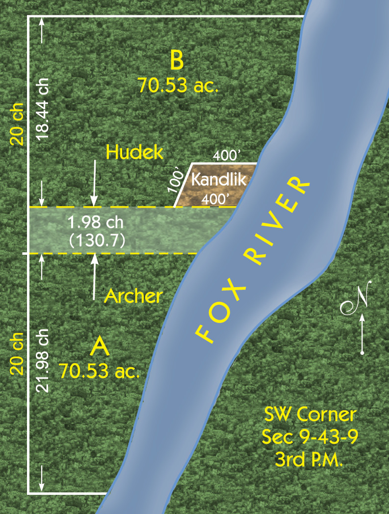
So let’s rewind the tape and run the play with Jim’s focus. Justice Stone cites Jackson v Dysling “It is a familiar doctrine of law, that title to real estate cannot be transferred by parol. It is settled, however, that proprietors of adjoining tracts of land may, by a parol agreement, settle a disputed boundary line between them. Such an adjustment of the boundary, if followed by corresponding possession, may be binding on the parties, not because it passes title, but because it determines the location where the estate of each is supposed to exist.”
Anybody care to describe what the physical evidence of a parol agreement and corresponding possession might look like? I suspect it might contain a series of weathered posts strung together with rusty wires and so did the majority in Kandlik. To Jim’s point, we should show the continuity of location between a fence and legal description where ambiguity is flagrant. This helps the lawyers and courts determine the applicability if we cannot. Conversely, we should apply the continuity of fence evidence with our opinion when owners have harmonized their interpretations.
Regardless of the migration or evolution of the technical language in these grants the tracts did not change on the ground. This seemed to be a no-brainer for the courts. Interestingly the chainees in title chose to re-adopt aliquot terminology after the original subdivision deviated from Tiffin’s PLSS schematic. This could color if not cloud or even break a chain of title. However, actions speak louder than words and the courts easily resolved this issue by considering how the folks behaved (i.e. built and respected fences following the original 1848 subdivision). Heck, there’s even a description in there that translates a parcel in both terminologies. If you subtract my side swilling and Justice Stone’s special concurrence, we are left with only the manifest evidence of the fence delineating the boundary. Great call Jim!
Jim offers his professional observation that “It was never intended that a deed should become a document to be followed literally without interpretation.” Well, Johnny H. Lawndarts on a popsicle stick! I share that same observation but I was too busy spouting off about how great those descriptions are. Come to find out that the majority subjugated those great deed calls to the owner’s interpretation of the boundaries. “the evidence clearly and overwhelmingly sustains the findings…that the fence…had been uniformly recognized and treated by the owners of such tracts as the division line since 1848”. Hankins crushed it here. Do you know who else nailed that point? Chief Justice Cooley.
Now, brothers and sisters of the congregation turn to page one of the rope stretchers hymnal and join with me in the inspirational recital as the choir backs us up. “When a man has had a training in one of the exact sciences, where every problem within its purview is supposed to be susceptible of accurate solution, he is likely to be not a little impatient when he is told that, under some circumstances, he must recognize inaccuracies, and govern his action by facts which lead him away from the results which theoretically he ought to reach. Observation warrants us in saying that this remark may frequently be made of surveyors.” AMEN!