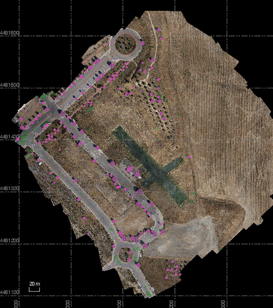
An example of automation, this classified point cloud in Trimble Business Center shows automatically extracted tree features.
Across the board, software technology is increasingly innovating the way business processes evolve, allowing for greater efficiency and accuracy than ever before.
Surveying industry processes are no exception, with the future trending toward integrated software and collaboration among project teams to extract valuable information from an ever increasing amount of data. The surveyor is now expected to play a key role throughout a project’s duration and must be armed with cohesive business software systems that allow performance beyond expectations. The software solutions used by geospatial professionals are often numerous and varied because they are specialized to many different activities, data types and trades. With improved collaboration and open data systems, construction projects can reap the benefits of shared data and reduced rework.
Role of the surveyor
Over time, surveying companies have diversified their businesses, and that trend continues. Survey is integral along a project continuum. Even so, clients increasingly own the process and dictate the rules of engagement, with surveyors needing to deliver or risk losing the work to someone else. Surveyors are highly integrated into project teams nowadays, representing both a challenge and an opportunity to grow and deepen relationships with clients. To grow and expand their businesses, surveyors must be pragmatic in choosing the right tools for the job, which often means changing old habits and embracing new opportunities.
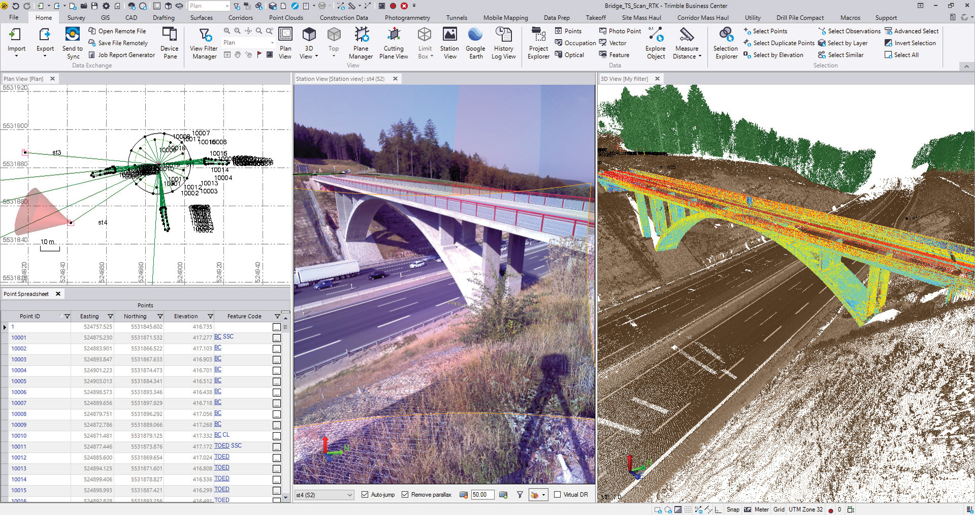
An example of data integration, this image shows data captured by the Trimble SX10 containing traditional total station observations, images and point clouds in a single software environment.
With that in mind, let’s explore best practices in evaluating and implementing software solutions for survey teams to ensure they are optimizing capabilities to generate core deliverables and unique services with confidence.
Here are eight actions savvy surveying businesses can take:

Be bold and ready to learn.
In a rapidly changing world, the quickest way to learn is to dive right in. With building information modeling (BIM) transforming construction projects today and digital twins and smart cities the view to tomorrow, the adoption of these concepts is still fundamentally based on geospatial information that describes the current state of a physical object or survey techniques to demarcate a virtual object in the real world.
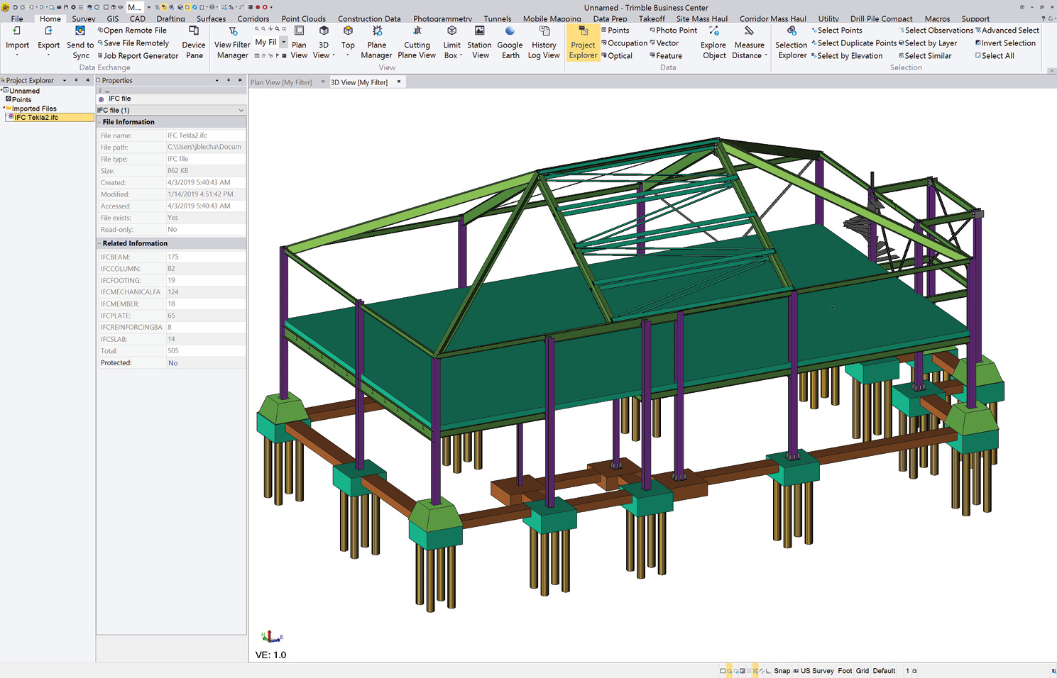
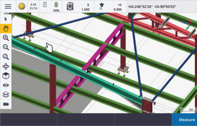
These two images show a BIM model in Trimble Business Center (office) and Trimble Access (field).
The technology and amount of data used to perform these activities continues to change, but the survey and geospatial principles to ensure accuracy and precise location generally do not change. Your expertise as a geospatial professional is therefore critical to achieve the productivity savings expected by the adoption
of BIM, digital twins and smart cities.
 Even so, you will need to learn and adapt so your knowledge provides critical value. Enroll in BIM information sessions, develop connections with industry peers and be bold in bidding for projects adopting BIM methodologies, with the intention to learn. Geospatial leaders are quickly finding their knowledge is more critical than they expected, and solving difficult on-site problems is the quickest way to learn and set themselves
up to take on modern projects.

Designate a software czar or a team of czars.
If you are a sole proprietor, then this is you. Likely, you are very pragmatic about your choices in software and need to carefully weigh the costs of any changes. But if your strategy is to expand, you’ll need to evaluate your well-worn paths and consider whether more efficiencies can be gained from different approaches to your software.
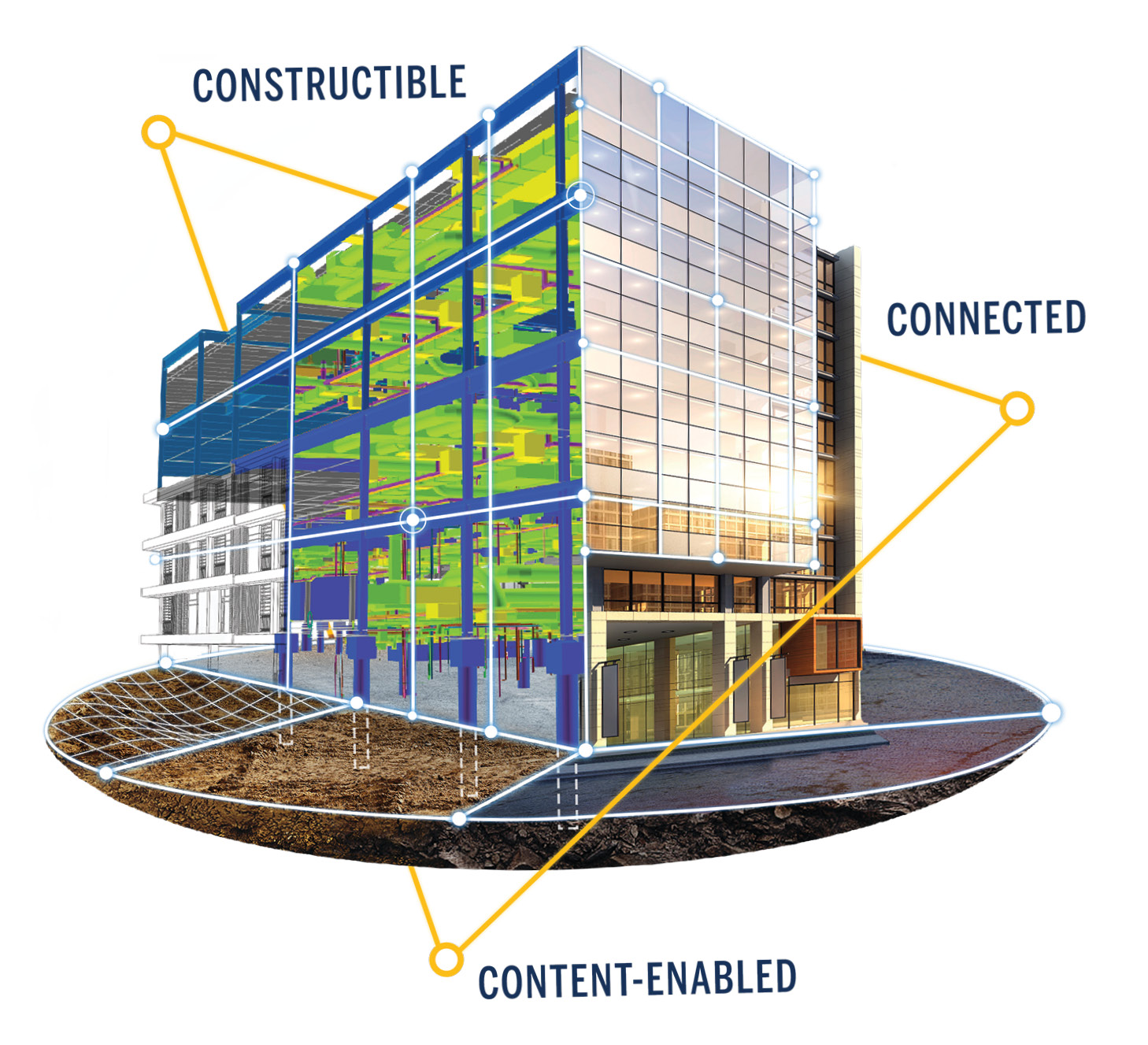
From bidding to building and beyond, the construction industry is moving beyond traditional BIM processes to drive more downstream value and better control fabrication and installation in the field. Connected systems to track, store, and display complex data on the fly help deliver valuable, actionable information to all construction stakeholders.
In slightly larger surveying businesses, a designated office professional typically analyzes information and prepares deliverables, while a field person collects the data. Hiring people for these positions who have IT knowledge—IT experts, professionals with dual survey and computer science degrees, or data scientists who are comfortable with cloud platforms and managing large amounts of data— can strengthen the business. These employees often prove invaluable because they know what the company needs to deliver and how to keep technology up to date.
As a best practice, these office professionals should lead continual analysis of new and existing solutions, new integration capabilities, training needs and investments needed to ensure the best mix of software solutions for the business.

Consult with an expert.
Sometimes you need to step back and seek out expert guidance, but it is hard to know where to find it. A good place to start is your geospatial solutions distributor. Often, distributors will have experts on hand to demonstrate new solutions and connect you to existing users. They also are a resource for user forums for asking questions and engaging with others in the profession.
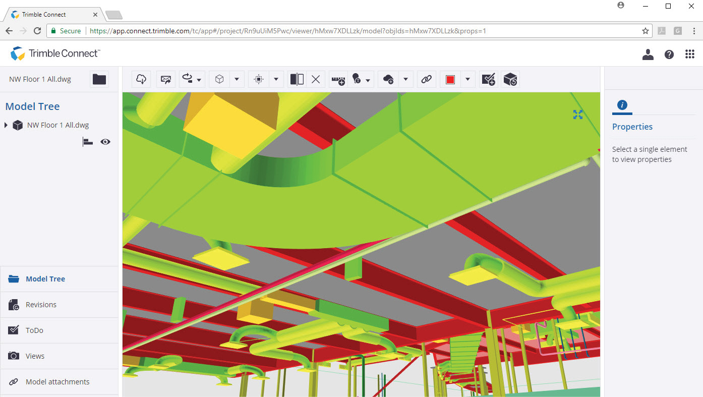
Cloud collaboration solutions like Trimble Connect democratize construction data so a wide range of stakeholders are able to view and consume the current files without the need for specialized software.
In addition, there are geospatial software consultants who can provide independent analysis of your current field-to-finish setup, explore opportunities and provide implementation recommendations. These professionals take a holistic look at your processes using a digitalization strategy. How do you collect data? How do you transfer it? How do data integration and office validation processes work? And what’s the most efficient method to generate final deliverables? Some organizations are getting savvy with these processes and hiring programmers to develop highly efficient, bespoke solutions.

Consider your data—protect it and choose flexibility to share.
As a geospatial professional you spend endless hours outdoors capturing data that is the foundation for the value you provide clients. Protecting data and client information is essential to protecting your business. Securing your devices, networks and updating software are obvious steps to avoid hacking or infiltration by malware. Backing up data has never been easier by storing across multiple servers or in the cloud.
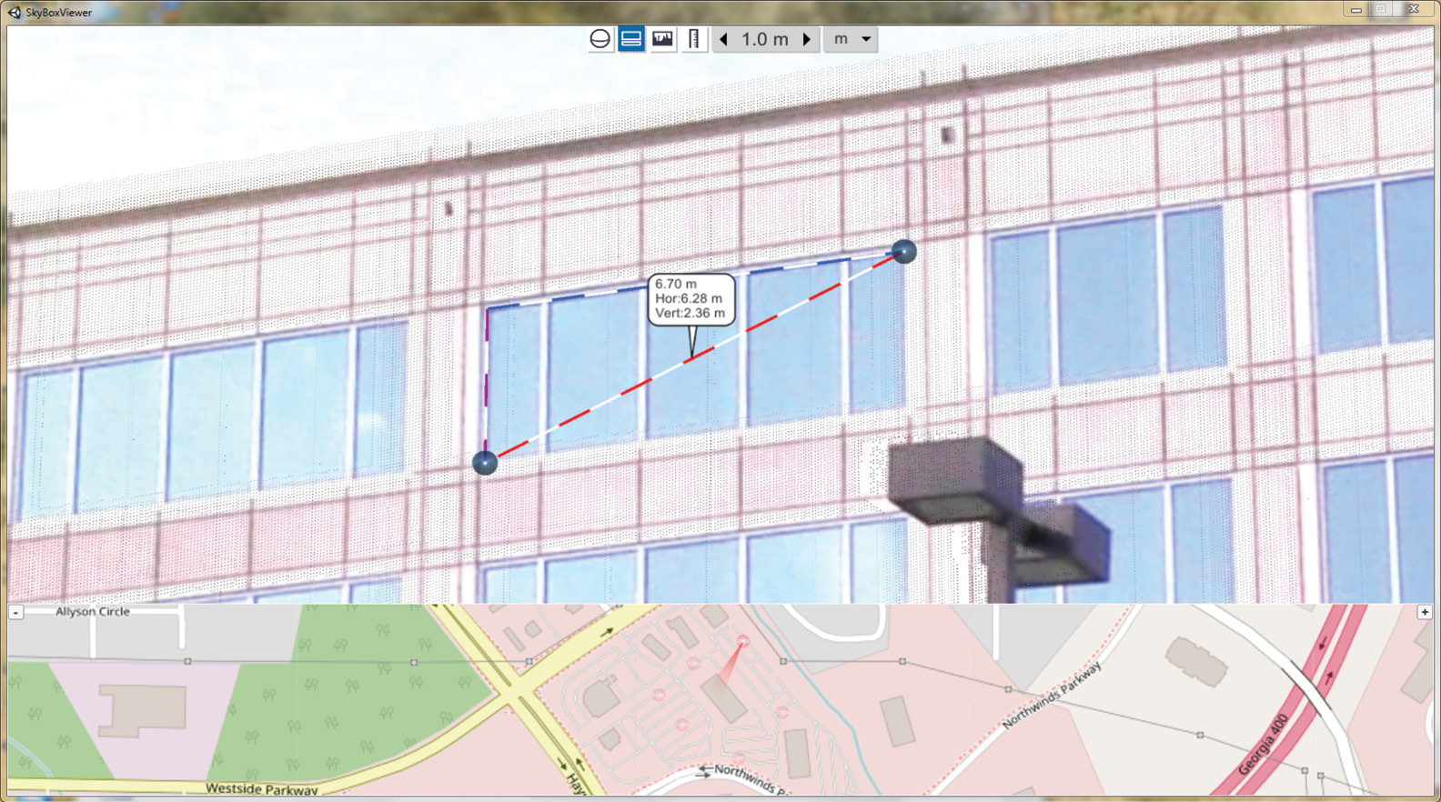
Clients can better understand project conditions through shared views of the data like this one using Trimble Clarity.
While you need to protect your data, it’s also critical to easily share, move and use your data with a range of different software products or cloud solutions. The adoption of BIM, in particular, is driving the use of rich data throughout the workflow process, demanding the use of more open data standards and improved data interoperability. These changes make it easier to collate data from different sources, track progress, analyze clashes and share information with project stakeholders. Geospatial software is adapting to these needs by ingesting data from multiple sensors, as well as supporting interoperability with industry and open standards or establishing direct connections between systems used to complete a workflow.
Trimble Business Center software exemplifies the benefits of data integration and interoperability by providing geospatial professionals with a data hub that’s flexible for choosing sensors fit for purpose. Whether GNSS, total station, levelling, lidar, imaging or photogrammetry—it doesn’t matter if the data is collected by walking, driving or flying. The result is one software solution for high-accuracy data, CAD deliverables and rich information with full traceability back to the sensor. Trimble Business Center also is increasingly data agnostic, supporting industry standard data types and interoperability with other solutions, including AutoDesk, Bentley and Esri products.

Select solutions with automated features.
Tools enabling factual decision-making from big data will be a large focus in geospatial software going forward. We are no longer talking about the collection of big data but the efficient extraction of meaningful information from large amounts of rich 3D scanning and imagery datasets.
However, you need to be selective in picking solutions that offer automatic extraction to ensure they match with your main application. While capabilities are rapidly expanding to support different applications and object types, the robustness of automatic extraction is the key to productivity savings. If you spend the same amount of time verifying the result of automatic extraction, then it’s quicker to extract objects manually. There is no magic “extract my CAD plan” solution available…yet. Software solutions that blend rich data types with existing workflows and automatic or semi-automatic extraction capabilities will provide your business with the greatest efficiency gains.
The focus is also shifting to how companies can do more with their data. With improved data interoperability, professionals farther down the value chain can view, use and share the data to make fast decisions. At the end of the day, you can collect all the data you want, but you also need to know how to make an informed decision with it.

Look for customization flexibility.
When selecting software, choose a solution that offers flexibility through customization. Many packages today come with application programming interfaces (APIs), which are really handy if you are integrating workflows with existing business process management software for tasks like invoicing and payroll.
You may find software that does 99% of what you need but is short by one command or operation, and the ability to customize makes it possible to add this functionality. Also look for software that offers extensibility via a macro language such as Python, ArcGIS or Trimble Business Center, or packages that come with well-documented software development kits (SDKs), which allow you to define your own workflows and extend the software capabilities.

Push into the cloud.
Cloud-based products and services are synonymous with global connectivity, information sharing and collaboration. For geospatial professionals, the ability to leverage the cloud for data processing and information extraction can expedite production of final deliverables. Cloud solutions are also proving critical in sharing those deliverables in an open and accessible format—vastly extending the base of potential consumers of that data, and in turn, driving more demand for valuable geospatial information.
Connectivity is a key driver for enabling productivity savings, and the future 5G network will minimize the current limitations of data upload delays and visualization performance, especially with rich 3D point cloud data. Rather than waiting for hours to upload data or shipping a hard drive, geospatial professionals will easily upload and utilize cloud processing solutions across distributed systems to quickly generate results. With the resultant data and information deliverables in the cloud, professionals can take advantage of data sharing and collaboration tools to help clients quickly make informed decisions and maximize the value of their data.
Cloud-based solutions, such as Trimble Connect and Trimble Clarity, provide coordinated construction information for
all project stakeholders to share, view, coordinate and comment on visually rich models. Viewers can review the data and collaborate via their web browsers on computers or mobile devices, without compromising integrity, security or performance.
The cloud also reduces the burden of the capital expenditures prevalent with traditional office business processes. Gone are the days of purchasing software licenses, setting up large-capacity in-house servers and having an IT team physically touch each computer in the office.
In fact, with cloud-based software, many businesses can forego investing in high-performance office computers by utilizing lower power and lower cost office hardware, including tablets and smartphone devices, to perform the most common tasks. Cloud-based storage provides physical security of the hardware, automatic backups and a strong defense against unauthorized access while allowing organizations to maintain ownership and tight control over their data.
The cloud also enables connected worksites, buildings, farms, cities and other projects a fluid transmission of information, avoiding downtime and allowing continuous progress.

Take advantage of the as-a-service business model.
The modern surveyor can’t do the job today without specialized software, and the software-as-a-service (SaaS) or software subscription model will continue to evolve to support project workflows.
The as-a-service business model is tied to the benefits of the cloud because it allows companies to more efficiently manage each project and reduce operational costs. Organizations pay
for only what they use and allocate software costs to a specific project.
Conclusion
Whether you are just beginning your geospatial software journey or have already conducted considerable research, you likely know how critically important it is to ease data frustrations for your business and livelihood.
These trends are certain: The volume of data will continue to increase, technology will continue to evolve, and processes will continue to automate. As a result, project stakeholders will continue to expect more from survey businesses. And as is characteristic of such an exacting profession, surveyors will find new and innovative ways to stay at the forefront of those evolutions.
Boris Skopljak is marketing director, geospatial strategy and analytics, for Trimble.
Tim Lemmon is marketing director, geospatial office software and applications, for Trimble.