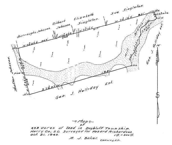
Don’t be fooled by Foose’s ignorance of local customs or the tentative south line on this survey. A. J. Baker’s work reflects the conditions of the conveyance and holds true to the local standards of care as we’ll see in the near future.
The Palmetto State is taste-o-graphically wedged on the continent between barbeque and boiled peanuts. That’s darn near the top of my food chain. In just another decade we’ll be calling South Carolina 400 years old. The cadastre of Carolina dates back just as far. In 1688 John Love wrote Geodaesia for Carolina as the first survey manual of instruction on the continent. This was a century before old T-Jeff started dicing up the Seven Ranges. I’ll call Love’s collection of standards the longest continual tradition of land surveying in America.
The court cut right to the chase on this one. “This action resolved itself into an action to try title to nine and one-half acres, largely woodland, which lies to the south of plaintiff’s admitted acreage, and to the north of the defendant. There is no question of adverse possession. It is really a dispute as to the location of the dividing line of the respective farms of the litigants. The issue was submitted to the jury which returned verdict for plaintiff and the defendant has appealed upon numerous exceptions.”
Okay, this case is the real deal based on a genuine ambiguity in the record. However, a sideshow emerged when a flying Wallenda grabbed the trapeze instead of his plumb bob. The surveyor was hired to wingding a temporary corner at the request of his client under the pressure of a real estate closing. Bad kimchee here, folks. We set the standards of our work, not the client. In this case the parties appear to write their own standards of care and invoke risk that the surveyor is expected to mitigate. At best that was just a waste of the client’s money. Worsley. Hey, since we’re all bending the standards here, I’ll take the liberty of warping the English language…ehhmm, worsley he’s philanthropically contributing his client’s money to FALF (the Feed A Lawyer Fund). So, a valuable side lesson here is that there is no such thing as half-drunk, half-pregnant, or half-surveyed. Do the whole job or nothing! This decision was affirmed without dissent so I’ll take that as the court discouraging wing dingers and move on.
The first order of business is the legal descriptions. These are bounds descriptions and yes they are legal. This is what they mean when they say “where the boundaries are is a question of fact, what are the boundaries is a question of law.” Among those facts are a collection of sequential conveyances. Missing from the evidence kit are the numbers and linear dimensions. Good, that simplifies the problem, right? Go recover the evidence left on the ground and move on.
Where it gets tricky is that our evidence now includes an unresolved matter of law. Is the 1943 survey presenting the tentative boundary line reliable as notice? This raises a whole bunch of peripheral questions. How long is the discovery period for finding the true line per this agreement? What if the true line is lost and the tentative position is lost or defective? Are the subsequent owner’s barred from acquiescence? Can the tentative line ripen through common report? I quote the decision “Mr. Atkinson agreed that the corner would be located where the latter (Holliday/defendant) thought it was, and that later, if found to be incorrect, it would be adjusted.” This is where things got really balled up. There’s an agreement about a boundary line but it’s not a boundary line agreement. Hold on a minute though, there’s a survey promoting the color of reliance on the line.
Despite my surveyor’s angst and confusion I think the courts did a great job with this. They followed the evidence and the law. Furthermore the printed “decision” clearly expresses the integrity of the questions and basis for the decision. “It is well established that where the dividing line between two coterminous owners is doubtful and to establish it they meet together and agree on a line the agreed line must be regarded in all future controversies to be the true line…the evidence here tended to show that there was no such agreement. Instead it was agreed, in effect, as has been said, that the line which was run for the purpose of the 1943 plat was tentative and subject to adjustment between the adjoining owners.”
I suspect this is Caveat Emptor, sort of. The agreement was not exclusively between the buyer and seller. It included the neighbor and don’t forget the successors in title on both sides of the line. I’m going to put on my Lucas Lawyer pants for a minute and ask the court where is the successors’ notice that this line is tentative? I have to believe that this agreement infringes on a future court’s authority to infer that any successors met the standards of acquiescence. I’m wondering if the decision inadvertently does the same? “Atkinson was present representing the owners of the adjoining land, who conveyed it several years later to the defendant, and no reason appears why his agreement that the location should be tentative should not bind his principals and their subsequent grantee, the defendant. The plaintiff, with his contract to purchase the adjoining land, was in the shoes of the Owner.” <emphasis added>. Despite the fact that “no reason appeared” in evidence, the “tentative line” notion doesn’t seem to fit the livery of deed standard from the days of yore. Imagine a humorous attempt at a Turf and Twig ceremony on a windy day with a handful of hourglass sand and a pricker bush. I picture the grantor losing all the sand between his fingers before the handoff and the poor grantee dropping the twig because it pricked his finger. It just doesn’t quite cut it but we give everybody an “A” for effort. I think the reason that the whole Register deal was able to fly was because everybody acted in good faith. The courts heroically respected the effect of the grant and measured the issue squarely with law. The surveyors had apparently done the best they could with what they were handed. They owners were all within the law and made a good faith attempt to disclose the uncertainty. After all, their goal is the successful completion of a land grant and the stability of the cadastre. This is a case where no survey may have been better than a tentative survey.
Other than the extrinsic evidence brought to court, I wonder how this tentative corner was memorialized? Sure there’s no reason that a subsequent owner shouldn’t be bound by the “tentative line” agreement if he knows about it. What is the likelihood of that? The opportunity to recover extrinsic evidence is greatly reduced after the agree-ors have faded away into the sunset. Our big lesson at this point is that a retracement survey is three dimensional in time. The subject is from the past, the concern is in the present, and the reporting is done in for the future. This case adds a fourth dimension. A promissory condition. Whether it’s the owners promising to tidy up loose ends after the closing or a surveyor’s statement committing to set corners after recording we know that a promise might not meet the intended standard of care down the road.
Just like the court I can only go with what’s in front of me and at face value. There’s not a lot to work with in this decision. I couldn’t even find the parcels on the Horry County website. But don’t you fret because every dog has his day. Using my plumb bob as a stylus I googled local surveyors on my smartphone. The very first one I contacted just happened to have the complete 1943 surveyor’s file on the case including the maps, correspondence, and court papers. I can’t express enough the importance of good record keeping and working with the local surveyors when you enter foreign turf. Now, anybody care to argue with me about respecting that longstanding tradition of land surveying in Carolina? CHAAAA-CHIIIING!!! We’re gonna bring the goods and really tear into this case compliments of Tim Davis RLS and Davis Land Surveying in Loris, South Carolina. For a PDF of the case see archive.amerisurv.com/PDF/RichardsonVersusRegister.pdf and feel free to email me at rls43185@gmail.com