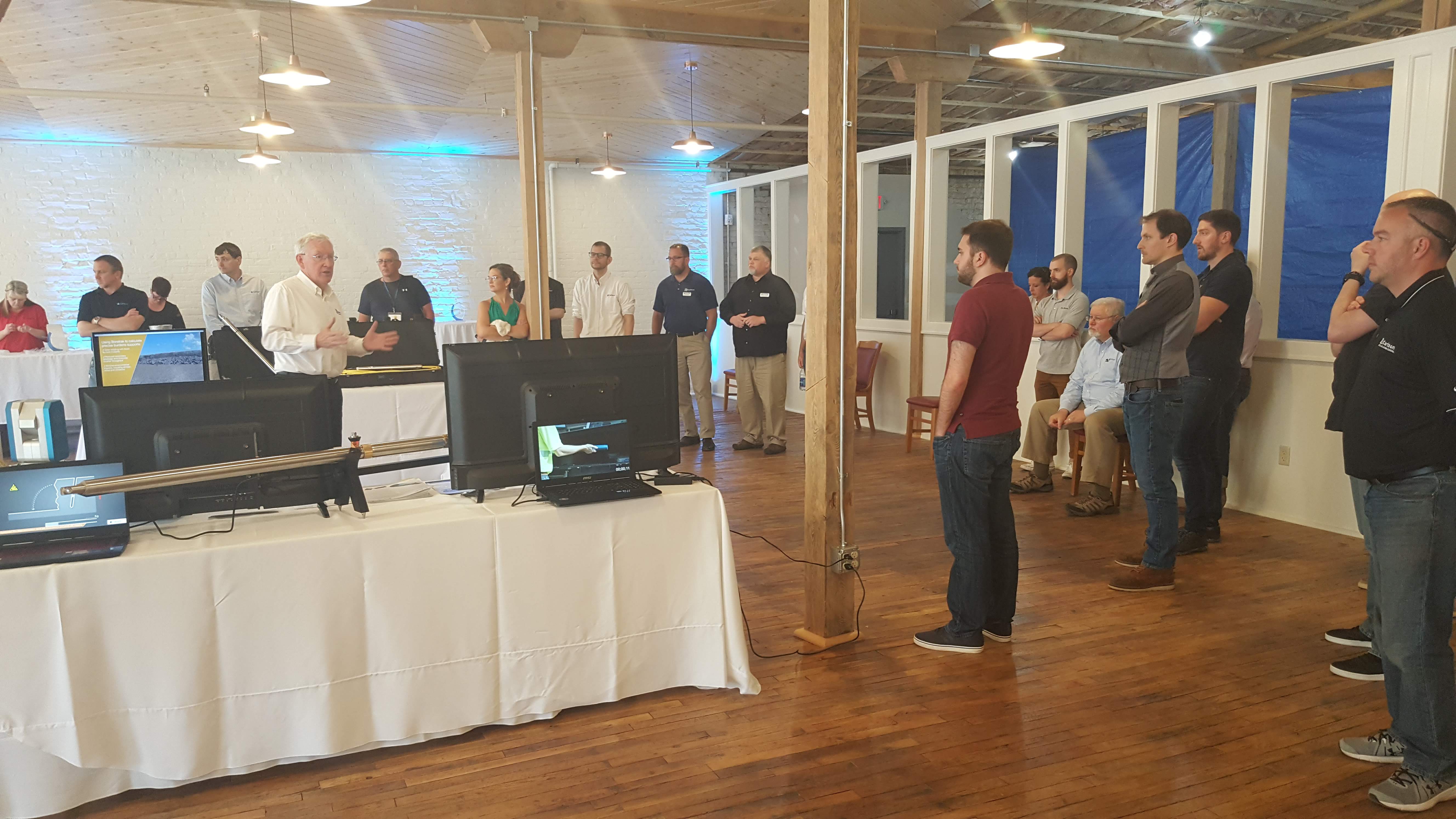
Bruce Carlson walks the crowd through Carlson’s latest hardware offings including a host of remote sensing and scanning technologies. Users we treated to a hands on reception showcasing Carlson’s growth in emerging technology markets.
The trend in user conferences is to scan as many bar coded, app driven attendees then cram them all in the largest urban cubicle that can be found. Heck, I even went to one that had more indoor pyrotechnics than a Kiss concert on the 4th of July. The 2019 Carlson User Conference was a gratifying release from the current mentality of big box corporate geovangelism. Carlson cleverly employs local assets and pleasantly immerses the conference among the beautiful Georgian and Federal architecture of historic Maysville, Kentucky. User sessions were interspersed throughout the flavorful architecture of this early Kentucky settlement. Every session break was a chance to indulge in the fresh spring air and enjoy a stroll through the picturesque backdrop of American history.
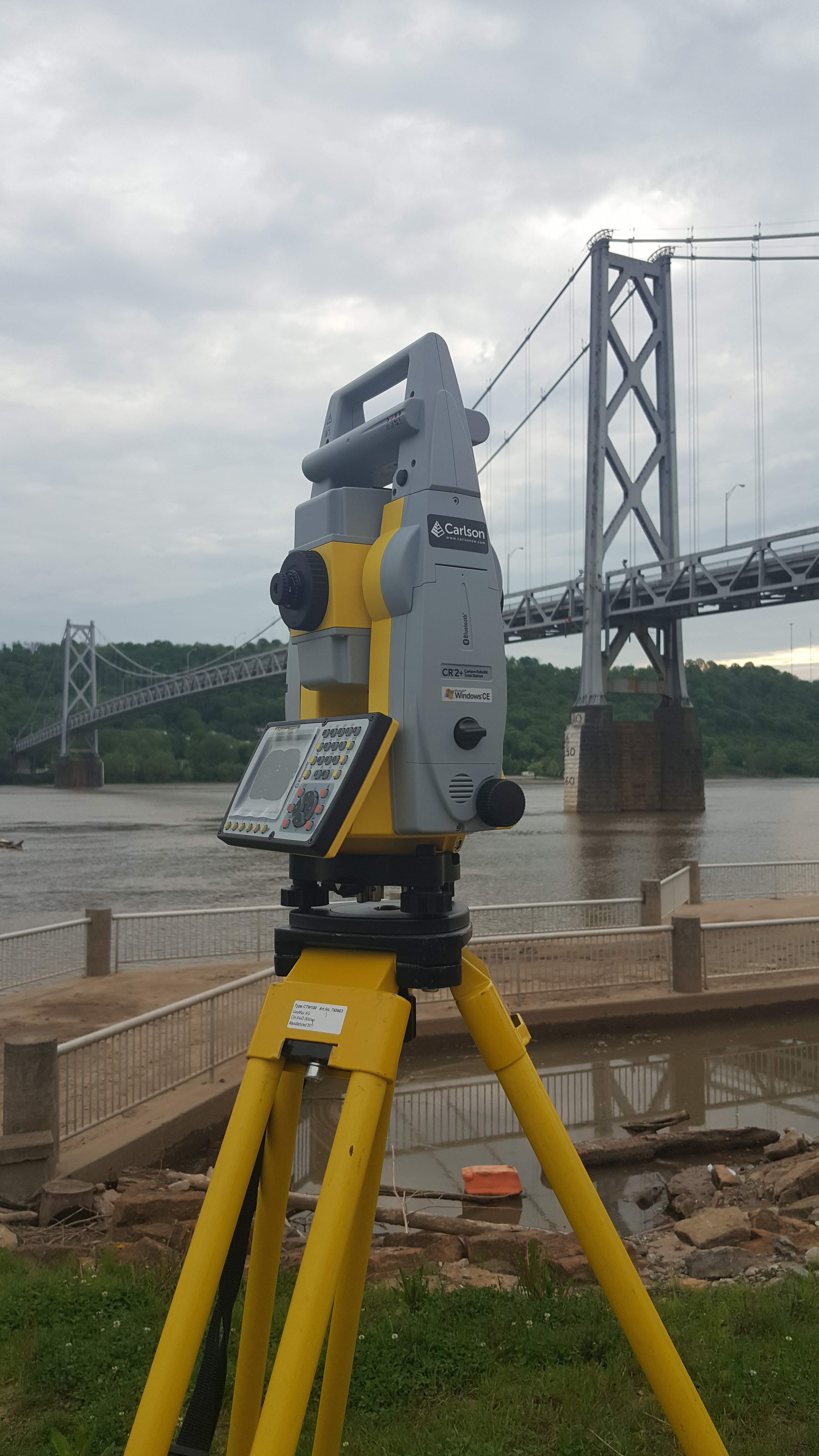
The robust scanning capabilities of the Carlson CR+Robotic Total Station were demonstrated on the historic Simon Kenton suspension bridge as traffic swayed safely across the river.
The big news at the conference was the ArcGIS-enabled version of Carlson SurvCE. True to form the Carlson team has once again transformed the software to fit our natural workflow. I watched users light up when the tech team dialed up the steam on the locomotive. Then something clicked and gap between surveying and GIS magically disappeared. SurvCE empowers the surveyor with enhanced field tools that enable control of the data at the scene of the infrastructure. Not just backdrop graphics and polylines but also real data tables and attribute updates. This includes creating attributes on the fly because in our world we are the often first responders having to quantify stuff that just don’t fit on anybody’s form. Remember the old slur “GIS stands for Get It Surveyed”? Well that is exactly what SurvCE does for every surveyor including those still wrestling with the antiquated notion.
SurvCE has always been as intuitive as slipping into a comfortable pair of work boots. The ArcGIS enhancements in SurvCE place the precision of CAD and the organics of GIS in the hands of the surveyor and right where they belong. The surveyor has powerful snap tools which immensely help in finding the ends, middle, and offsets of just about anything on the ground. Feature positions, attributes, and their associated linework automatically adjust when position is measured or remeasured. I don’t know if the industry realizes this yet but Carlson has effectively removed a complete step in the surveying process. It’s the part where an object is too flubbery to map in cad and the words just won’t fit in the attribute text field so you have to burn up time with phone calls and wasted trips. SurvCE brings all of the geo-quantification power to the scene of the incident where the surveyor can triage or better yet cure the problem on the spot. Finally, GIS is now in every surveyor’s field kit.

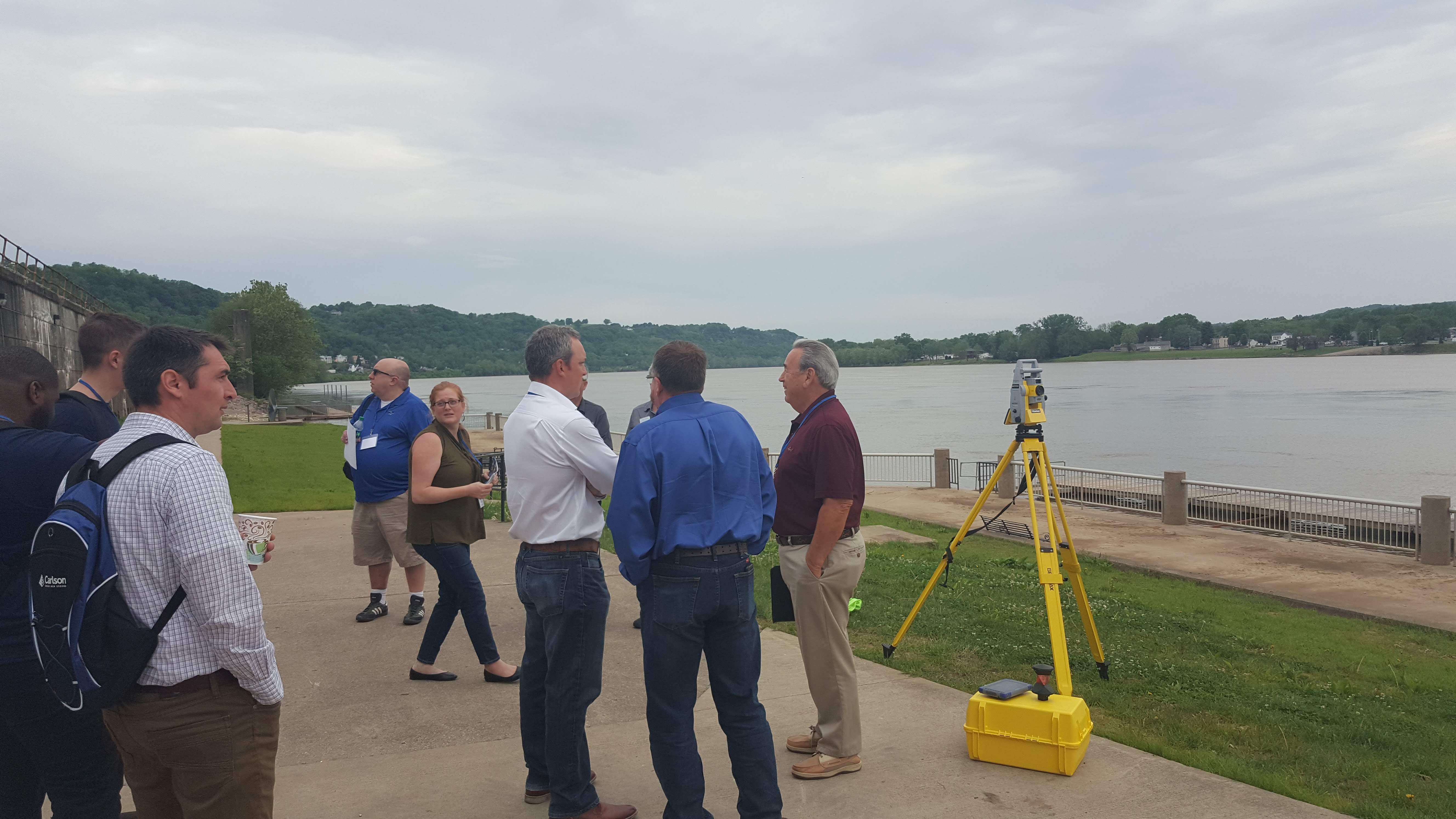
History meets technology at this international user conference nestled on the peaceful banks of the Ohio River.
A showcase of survey hardware featured a full boat of the latest and greatest technology. The BRx6 GNSS receiver is tight. It’s a 5-½” puck that weighs 3 pounds. For god’s sake I’ve eaten hamburgers bigger than that in my heyday. Those cardiac cakes as I now call them also didn’t have the five constellation capability of the BRx6+ which includes GPS, GLONASS, BeiDou, Galileo, and QZSS. The BRx6+ also has integrated Atlas L-Band for Precise Point Positioning through a subscription service. The BRx6 is really geared up for wireless communication which includes a 4G Penta-Band LTE cellular modem, an integrated UHF transceiver, Wi-Fi, and Bluetooth. I’m not sure how you fit all that into something the size of a double Whopper with cheese but Carlson has. This connectivity is really leveraged through Carlson Listen-Listen and the Carlson RTK Network that connects the base and rover through the cellular modem.
This is a real game changer folks. Carlson has harnessed the power of Amazon’s cloud delivering a low latency service to SurvCE/PC users running the BRx6 GNSS as a base station. Amazon’s web service provides the muscle of unlimited processing power, speed and the bandwidth necessary to pull this off. The service eliminates base line length restrictions associated with using UHF radios. Listen-Listen runs on your single base feeding your multiple rovers. Any rover hardware can be dovetailed with the BRx6 base. There’s a value added savings here by trimming the fat from rover end of the setup and having the ability to run any combination of rovers simultaneously.
David de Bethel, Engineering Director, Laser Measurement Devices at Carlson Software shares his knowledge of hardware production at Carlson’s York, England facility.
The Carlson NR3 is a great example of the cost efficient dedicated rover for a Listen-Listen setup. The size of a stack of small pancakes and weighing about the same at 1.8 pounds, the tiny NR3 packs a wallop with an integrated 4G LTE cellular modem, Wi-Fi and Bluetooth for modern wireless capabilities. The NR3 uses 4 constellations to produce reliable GNSS RTK, with triple-frequency tracking on GPS, GLONASS and Galileo. The Carlson tech folks say that “The solution incorporates multipath and ionospheric detection algorithms to maintain accuracy, while exhibiting stable satellite tracking during shocks or vibration”. The lightweight NR3 receiver may be used independently as a base or rover and being so light it is the ideal rig for the Hybrid+ robotic total station rover.
The users discuss remote sensing opportunities of the robust CR+RTS while out of harm’s way as the robot is hard at work scanning a live bridge deck.
Carlson laid out a pair of very robust data collectors at the conference. They are both built like tanks. I think it’s just a matter of keyboard preference, screen size, and options when closing the deal on either. The Surveyor 2 is for the traditionalists who prefer a tactile QWERTY keyboard and a 4.3” touch screen. It has 8GB of flash storage and 1.0 GHz processor. The long range Bluetooth will reach out to 1,500 feet when paired with class I devices and according to the brochure you will get 20 hours out of your batteries. There’s an integrated camera and 3G modem all wound up in an IP68 water & dustproof, shock resistant package. The RT3 is a ruggedized tablet with a 7 inch screen and milspec tough. Battery time is 8-10 hours expandable to an additional 4-5 hours. Two cameras, long range Bluetooth, Smart Ready Wi-Fi, 4G LTE and 128GB of flash storage are configurable with the GEO CELL model. The optically-bonded capacitive touch screen is chemically-strengthened with Dragontrail™ glass for excellent impact & scratch resistance.
The whole world hasn’t caught up to point cloud technology just quite yet. We’re close as the stragglers marvel at a point cloud but ask “Where’s my contour map and cross sections?” A really nifty thing happened at the Point Cloud software session. Interaction and dialogue opened up some really valuable lessons and techniques learned by the tech team and the users. As an aside, this wasn’t particularly a “Carlson thing” but more of an industrial standard being hashed around. That’s the value of a user conference and open source development. Long story short we all win from sharing industrial knowledge and that is a Carlson thing. Okay, so the session started with a multi-million point cloud file of an acre or so of vacant field. The session leader, Ladd Nelson of Carlson, demonstrated how to effectively parse down the data through file versioning. We ended up with a neat and efficient file to work with while keeping the original large data file on the shelf for reference.
User dialogue led the group to experiment and parse down the compact 50,000 point file version even further. The suggestion effectively was to model a sampling of points that replicated a traditional surveyor’s 50’ grid and breaklines. The result yielded a great looking and smooth traditional contour map with almost no noise. It was also discovered that drawing clean-up time could be greatly reduced. The realization was finding a point of diminishing returns between the “data in” and the “data out”. We learned that scaling the dataset to traditional land surveying standards will yield customary results. More data is not always better; it could just be more to bog down a CPU or bandwidth in the post processing. In effect we virtually topo-ed the point cloud just like we were in the field to create a familiar and useable deliverable. In a nutshell the “thinking” part of the topo process has shifted from the field to the office because a point cloud allows us to see virtually everything. Good stuff!
The theme of the 2019 Carlson UC was “Grow with us”. Having survived the 2008 depression it’s invigorating to once again feel industrial optimism. Carlson is reinvesting in laser scanning and geopositioning technology. For the surveyor this means more cool tools and greater opportunities to build our client base. Carlson Boretrak is a tool currently used in the blasting industry to measure the pitch and depth of a dynamite hole. The measurements control choreographed rock blasts, keeping the neighbors safe from flying debris, and of course saving money. Boretrak resembles a set of folding tent poles that will stretch the sensor out as far as you can push it. Anybody that has designed, constructed, or as-built anything with pipe will see the immediate value of this real time sensor system. Whether you drill 2000’ deep wells in arid southwest, or you’re the facilities manager in the BIM realm, or a contractor in a design/build environment, I’m willing bet there’s “I could have used one of those” stories for Boretrak.
C-ALS (Cavity Auto-scanning Laser System) is like a big dentist’s mirror that creates georeferenced scans of inaccessible nooks and crannies. The moment I saw C-ALS I thought “I’m never going to have to dip another manhole ever again. Hallelujah!” C-ALS is currently deployed in mining applications when a conventional scanner is impractical to setup or can’t see certain voids or cavities. Carlson claims it’s the only borehole-deployable laser solution on the market. When queried about the “only” designation, Bruce Carlson said, “We are able to go into the smallest diameter borehole (as little as 3” diameter)—that is one of the differentiators. And we track the position to the laser head precisely using INS technology including using a precision, low-drift gyro. There are a couple competitors, but none have our precision to the laser head position through a corkscrewing and bending borehole, and none can fit under 3” that I’m aware of.” Once again my mind drifts to opportunities in the built environment. Consider cities like New York or Boston where the subterranean components of construction are always a crap shoot between geology, archeology, and the international building code. Workers constantly fiddle with that delicate ecosystem which the folks at Tammany Hall refer to as infrastructure. The project intelligence gained from a tool like C-ALS is a godsend to a contractor in dollars, cents, and safety.
Carlson UC 2019 was a great experience. From the pleasant setting, to the new technology, and the education offered it truly was one of the most enjoyable conferences I’ve attended. The next Carlson User Conference is slated for April 20-22, 2020 in Portland, Oregon, at the Sheraton PDX and it’s already penciled in my calendar.
Jason Foose is a Professional Surveyor licensed in multiple jurisdictions.