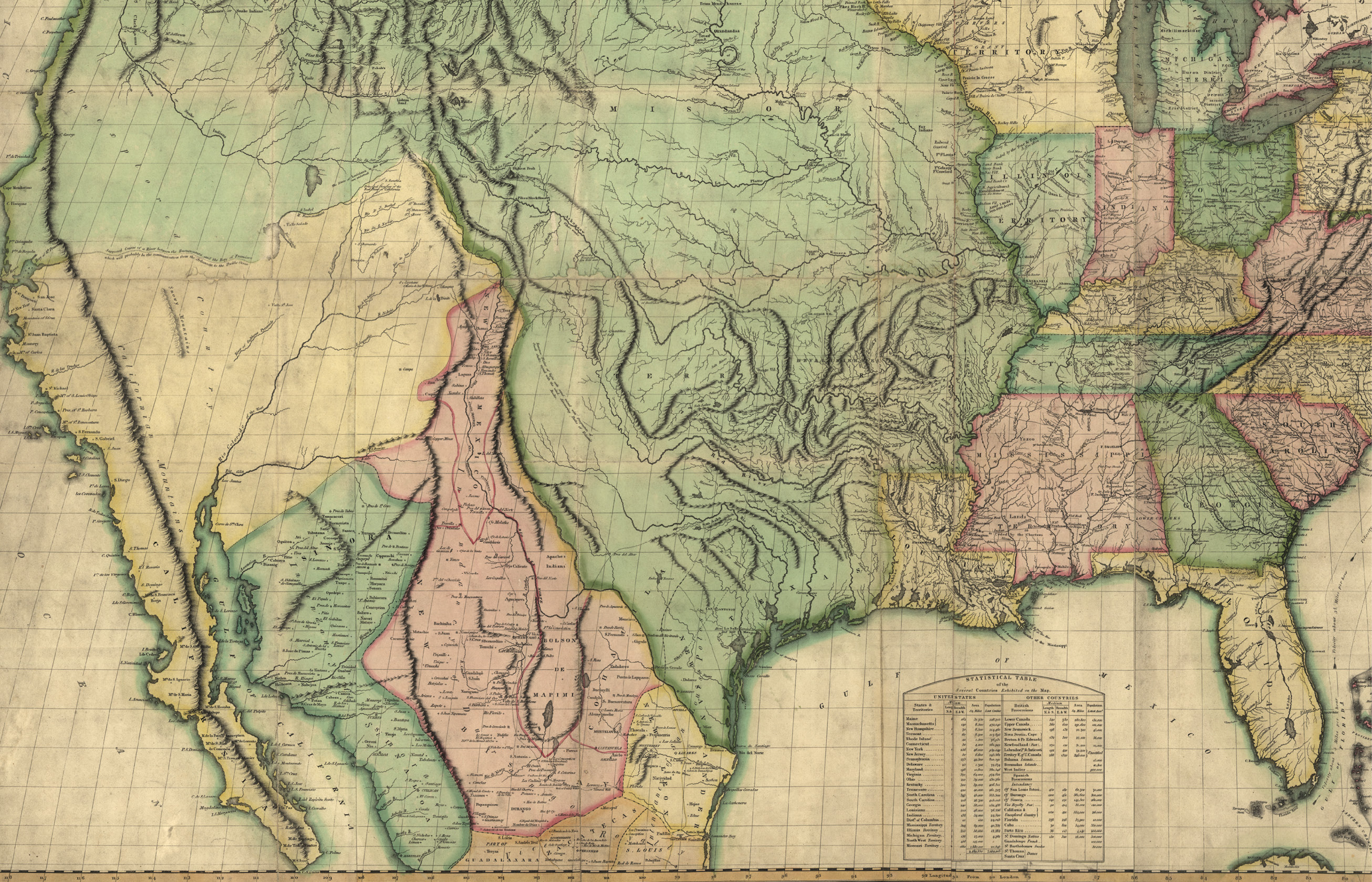
Map of the United States of America with the contiguous British and Spanish possessions. Relief shown pictorially. Published by John Melish in Philadelphia. Entered according to Act of Congress in June 1816. Map courtesy of the Library of Congress.
Banquo’s Ghost
The troubled Red River boundary between Oklahoma and Texas is like Shakespeare’s Banquo’s Ghost, “It Will Not Down.” From a vague beginning its vexing location has been the subject of international treaties, intrigue, three decades of litigation in the U.S. Supreme Court, inadequate definitions of the boundary’s location, surveys, resurveys, boundary commissioners’ reports, a Boundary Commission, a Boundary Compact and, most recently, renewed controversy, more resurveys, litigation and an Act of Congress. This ambulatory riparian boundary, always subject to the whims and vicissitudes of Mother Nature, has confused attorneys, confounded the courts, conflated commentators, and brought consternation to boundary surveyors and conjecture and indefiniteness to the affected landowners.
An outcome from the 1920’s “Red River Litigation” in the U.S. Supreme Court was the invention of a brand new riparian boundary term, the “gradient boundary,” and its also new accompanying field surveying method for determining this boundary. This term and method are attributed to Texas surveyor and engineer, Arthur A. Stiles (with acknowledgement to the GLO’s Arthur D. Kidder, a Boundary Commissioner appointed by the Supreme Court, along with Stiles). This new riparian boundary definition and field method was approved by the U.S. Supreme Court for use along the Red River as the boundary between Oklahoma and Texas (in 1923). It subsequently was adopted by the Texas Supreme Court for use in Texas as a riparian boundary but it has not been used or adopted anywhere else in the United States.
This article, Part I, traces the history and background of the Red River as a boundary between Oklahoma and Texas, from its genesis, the Louisiana Purchase in 1803 through the frequently-cited 1952 article written by Arthur A. Stiles, the “Father of the Gradient Boundary Method.” (Part II will cover from 1952 to date.) As we will see, this boundary is rich in history, law, science and the technical aspects of surveying.
The gradient boundary along the south bank of the Red River, the state line between Oklahoma and Texas, like Banquo’s Ghost, has recently reappeared and is ongoing. A few years ago the Bureau of Land Management (BLM) began surveys to establish part of the Oklahoma-Texas state line. After strenuous objections by Texas landowners as to the BLM’s methods and their location of the boundary, and a federal lawsuit with the BLM as the defendant, the Bureau suspended its surveys. Banquo’s Ghost will not down.
Surprisingly, a literature search for the story of the Red River Litigation and its resulting gradient boundary method resulted in not one book or monograph which gave the history of this most consequential and controversial boundary, the most epic boundary litigation in U.S. history. No one, it seems, has told the story. It will be quite an undertaking because the story will contain about equal parts of history, science, law and technical/professional surveying subjects. And, the record is voluminous. Tens of thousands of pages of treaties, letters, minutes, proceedings, testimony, reports, decrees, maps, surveys and photographs. It would be quite a task. Regrettably, perhaps part of the reason for the current, ongoing controversy over the boundary is due to today’s parties not having a full understanding and appreciation for the history, law and surveying which has preceded. There seems not to be an available succinct summary.
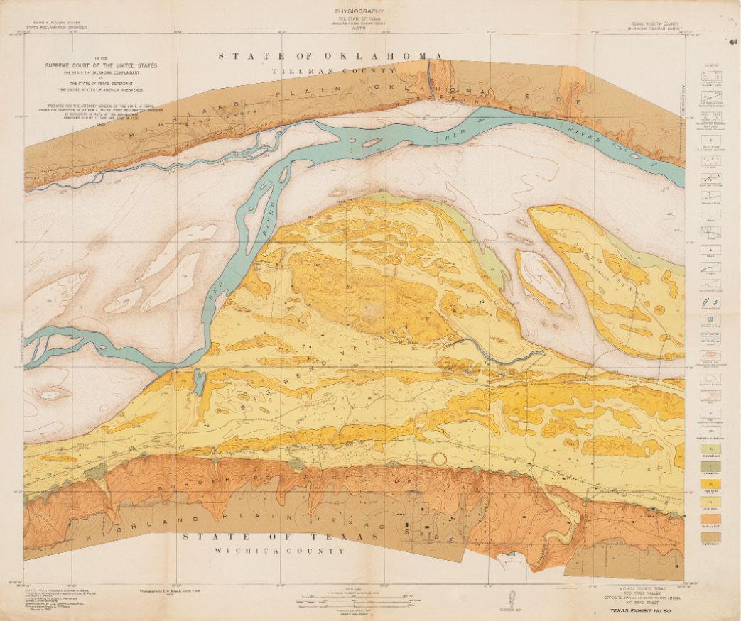
Map of geology in parts of Tillman County, Oklahoma, and Wichita County, Texas, showing regions colored according to geological features, contour lines, and elevation. The map also includes buildings, roads, fences, bodies of water, trees, oil wells, and U.S. Supreme Court temporary points and receivership boundary. Scale 1:6,000. Note: A full-size version of this map, complete with title block and notes is available at archive.amerisurv.com/docs/RedRiverGeology.tif. Map courtesy of the Jesse Wallace Williams Map Collection at Hardin-Simmons University.
Red River as a Boundary
What is today the Oklahoma-Texas state line was first an international boundary between the United States and Spain, created by the 1803 Louisiana Purchase. Surprisingly (but perhaps not to surveyors), the “Cession of Louisiana” treaty contained no boundary description (see 8 Stat. 200). So, the largest and most important expansion in United States history has no boundary description! The only reference to the Purchase boundaries is in Article I: “…the Colony or Province of Louisiana with the same extent that it now has in the hands of Spain, and that it had when France possessed it….” For some years thereafter the southerly and westerly boundaries of the Louisiana Purchase were only vaguely known. To clarify that boundary, the far-reaching Adams-Onis Treaty of 1819 was negotiated between the United States and Spain (see 8 Stat. 252). Spain ceded Florida to the United States, and the U.S. renounced its claim to Texas. Applicable here, the Treaty does contain the description of a line, meant to be the boundary between the United States and Spain: It began at the mouth of the Sabine River at the Gulf of Mexico, went up the Sabine, then departed the river “…thence, by a line due north, to the degree of latitude where it strikes the Rio Roxo of Natchitoches, or Red River [northeast corner of Texas just north of Texarkana]; then following the course of the Rio Roxo westward, to the degree of longitude 100 west from London and 23 from Washington; then, crossing the said Red River, and running thence, by a line due north to the Arkansas; thence, following the course of its southern bank of the Arkansas….The whole being as laid down in Melish’s map of the United States, published at Philadelphia, improved to the first of January, 1818…[continuing]…to the South Sea [Pacific Ocean].”
The Article continued to allow navigation of the Sabine, Red and Arkansas Rivers and that they “shall be common to the respective inhabitants of both nations.” And, the “contracting parties” essentially quitclaimed to each other the lands opposite the line described.
The “nut” of the boundary description language “at issue” will be the part which goes “north…to…where it strikes the…Red River, then following the course of the Red Roxo [River] westward…then crossing the said Red River….” and thence north. To Texas “to the river then following the course” of the river will mean its thread. To Oklahoma, it will mean its south bank. It will take the U.S. Supreme Court to decide which is intended by the treaty language.
The reference to Melish’s map will become very important many years later when discovered that the “true” position of 100 degrees of longitude (measured astronomically) will differ by about 100 miles from the 100th meridian location as mapped by Melish. That issue will be before the U.S. Supreme Court: Which controls the 100th meridian position? By celestial observation or as-mapped on the document referred to in the treaty? Be a Supreme Court Justice, what’s your opinion?
The Adams-Onis Treaty of 1819 was between the United States, and through mesne treaties and enactments (Mexico, Republic of Texas, State of Texas, Territory of Oklahoma, Indian Territory and State of Oklahoma), the boundary described in the treaty became the Oklahoma-Texas state line along the Red River.
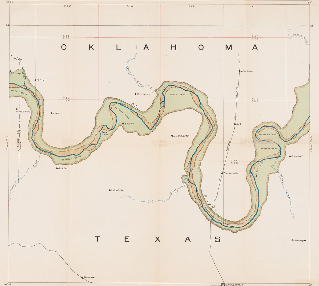
Map of the Red River in Clay and Montague Counties, showing flood plains, cut banks, and sandy beaches along the river. The map also includes creeks, towns, and railroads (Missouri-Kansas-Texas Railroad and Chicago, Rock Island and Pacific Railroad). Scale [ca. 1:63,360] (1 mile to the inch). A full-size version of this map, complete with title block and notes is available at archive.amerisurv.com/docs/RedRiverStiles.tif. Map courtesy of the Jesse Wallace Williams Map Collection at Hardin-Simmons University.
The Red River Litigation in the U.S. Supreme Court began in 1892 and concluded in 1925. The Supreme Court, as the court of original jurisdiction in state boundary disputes, was the trial court and not an appellate court. There seems not to be a good summary work on this litigation in the Supreme Court, but one can imagine the volume of materials which would have emanated. Maps, plats, photographs, reports, tables, testimony, decrees, etc. And, the scope of the litigation went way beyond surveying, mapping and the gradient boundary. The litigation was the most epic boundary litigation in U.S. history.
The Court Has Spoken—Now Call the Surveyors
At the conclusion of the “guts” of the Red River Litigation, in 260 U.S. 606, 1923, the U.S. Supreme Court announced where on the south bank of the Red River the Oklahoma-Texas boundary was located:
Upon the authority of these cases, and upon principle as well, we hold that the bank intended by the treaty provision is the water washed and relatively permanent elevation or acclivity at the outer line of the river bed which separates the bed from the adjacent upland, whether valley or hill, and serves to confine the waters within the bed and to preserve the course of the river, and that the boundary intended is on and along the bank at the average or mean level attained by the waters in the periods when they reach and wash the bank without overflowing it. When we speak of the bed we include all of the area which is kept practically bare of vegetation by the wash of the waters of the river from year to year in their onward course, although parts of it are left dry for months at a time, and we exclude the lateral valleys, which have the characteristics of relatively fast land and usually are covered by upland grasses and vegetation, although temporarily overflowed in exceptional instances when the river is at flood.
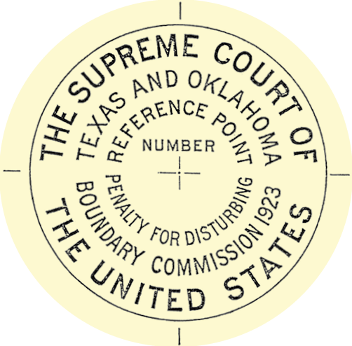
The reference monuments on the Oklahoma side are correlated with the United States General Land Office public land subdivisional survey. Each one is an iron post, 36 inches long, 2 inches in diameter, having a bronze cap. These monuments are appropriately marked according to the standard specifications of the General Land Office. They identify the position of the monument in the United States rectangular survey system.
Every judicial body since the Romans has tried to define a line along the bank of a river to be used as a boundary with sufficient specificity that it can be reproduced with certainty at exactly the same location by all future boundary surveyors. All such attempts have failed, mostly because the courts are trying to define a line along an object which is a landform. A specific, universally repeatable line to a landform which changes…that’s hard to do. But here the Court got close, and then appointed Boundary Commissioners to take their specification for the line, go on the ground and find and survey the line.
And that’s what Arthur Stiles and Arthur Kidder did. They went on the ground with the Supreme Court’s decision in hand and developed the gradient boundary method. Stiles literally had the Supreme Court’s decision in hand. A copy of that decision with Stiles’ handwritten notes and comments written in the margins is extant. Across the first page he wrote: “This is my marked copy which I used on the river prior to printing our First Report, April 25, 1924. Signed, Arthur A. Stiles, Comm.”
The purpose of this article is not to describe how the gradient boundary is determined and surveyed (there are seminars in Texas for that). But, what Stiles and Kidder did was a two-step process: 1.) Find the lowest “qualified bank” which first confines the waters when they arise from the bed. 2.) Establish the “benchmark elevation” on that bank which is the point halfway between the location where the flowing water reaches the bank and the high water level when the flowing water just reaches the top of the bank without overflowing it. The boundary is the gradient of the flowing water in the river through the “benchmark elevations.”
 The 1952 Stiles Article
In 1952 Arthur Stiles wrote an article titled “The Gradient Boundary—The Line Between Texas and Oklahoma Along the Red River” which appeared in the Texas Law Review (see Volume 30, Pages 305322, 1952). The article is the best written explanation of the gradient boundary and the field surveying techniques to determine it. And, written by the man who invented the term and the accompanying field method to find and survey the boundary, all approved and adopted by the U.S. Supreme Court. In April, 1927 the Boundary Commissioners had filed with the Supreme Court their Fourth Report (their last). It seems odd that Stiles would wait 25 years to write his explanation of the gradient boundary method (when he was 81 years old). A literature search on the topic reveals no other learned articles on the method during those years.
The article discusses his work on the Red River as a Boundary Commissioner (along with Arthur Kidder), their field work applying the Court’s specification of the line to the circumstances found, how one determines the key bank or the qualified bank and how the line is “…determined by the surveyor with his level….[It being] the only surveying instrument with which the gradient boundary can be located on the ground.” Continuing: “establishing this boundary is a far cry from land surveying. This is the work of the professional topographer and the experienced hydrographer….Finding the one correct bank in the vicinity that locates the gradient boundary upon the ground is no casual undertaking….[To find] it is necessary to have a thorough understanding of the requirements of the court….The…bank can be found only by close study in walking the banks, not by inspection from a distance….No intelligent idea of the river can be had from survey diagrams, aerial photographs, or contour sketches made from them and examined in some office….Finding the bank means hard work on foot on the river.”
The article goes on, in some detail, to describe field surveying methods for finding the boundary bank and surveying the gradient boundary. It remains the best reference on the “Stiles Method.”
The Stiles article can be found at archive.amerisurv.com/PDF/TexasLawReviewV30No3-1952TheGradientBoundary.pdf
Closure
For any resurvey of any part of the Oklahoma-Texas boundary, it seems evident that those professionally licensed to determine it should be knowledgeable of its history and development. They should be professionally trained in the field determination of the boundary and follow Colonel Stiles’ admonition to carry with them “the opinion and decree of the Court,” as he did. The boundary established must comport to the decisions of the U.S. Supreme Court and the Reports of the Boundary Commissioners. One might wonder how many licensed surveyors conducting gradient boundary surveys have studied those documents and what education and tutelage they have received in the “Stiles Method.”
Note: A longer version of this article, including the court proceedings, can be found at archive.amerisurv.com/docs/Elgin_RedRiver_LongVersion.docx