Delft, February 5th, 2019. Drone company Atmos UAV has just expanded its camera options. Through multiple R&D projects that lasted almost 3 months, Atmos’ engineering team optimally integrated additional cameras that are now available for their customers. Furthermore, the team also launched the newest version of MarLynk, the flight planning and ground control software provided with every Marlyn unit.
The available payload options that come with Marlyn. On the left is the integrated RGB Sony QXI and next to it the new sensors.
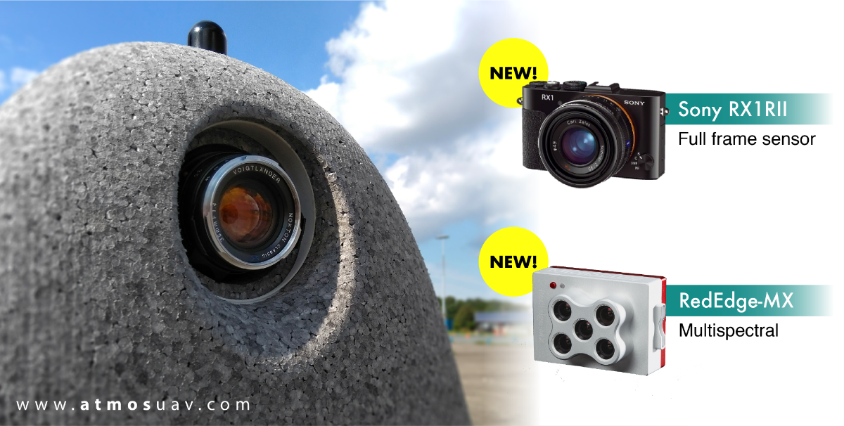
New camera options
To further satisfy the customers’ needs for ever higher accuracy, ATMOS UAV extended its camera options to include the RGB Sony RX1RII Full Frame camera and the new MicaSense RedEdge-MX, on top of the Sony QX1 it currently carries.
The new Sony sensor offers an unprecedented ultra-high definition of 42.4 MP (8,000 × 5,320 pixels). Its resolution and 35 mm lens enable the operator to achieve a GSD and resolution down to 1 cm even in the most challenging and demanding projects.
Insightful multispectral imagery has recently been linked to an increase in the success of agricultural applications. With the new RedEdge-MX and its 5 narrow bands (R, G, B, RE, NIR), you can now generate plant health indexes and RGB images in a single flight!

The new interface of MarLynk.
New software
Living up to their motto, “Made by surveyors, for surveyors”, ATMOS UAV continuously implements the feedback that they receive from their clients and industry experts.
After being extensively tested by Atmos’ Expert User Panel, the latest version of MarLynk software has just been launched! New features and a completely improved and more intuitive interface are now available to all Marlyn users!
What’s new:
- An intuitive graphical user interface with new icons and more straightforward flight planning and monitoring.
- Ability to plan multiple mapping areas in a single flight.
- All-in-one software. No paper checklists required.
- Ability to download offline background maps and perform mapping projects even without access to the internet!
- Less operator workload (streamlined process).
A walkthrough video of the new software can be found on Atmos’ new youtube channel.
About ATMOS UAV
Atmos UAV is a Delft (NL) based company specialized in the design and production of high-end aerial surveying and data collection drones that enable professional to gather geospatial data effortlessly from the sky, enabling them to make more informed decisions. The flagship drone model Marlyn has a unique design that combines the high performance of a conventional fixed-wing aircraft with the flexibility of a quadcopter. With their patented technology the company targets mapping, construction, mining, agriculture, and environmental applications to name a few. To facilitate the fast growth of the company Atmos is currently attracting new talent to expand the team.
Contact
To find out more about the company and its products, please contact ATMOS UAV B.V.
Address: Molengraaffsingel 12, 2629 JD, Delft, the Netherlands
Website: https://www.atmosuav.com/
Office: +31 (0) 15 – 744 0321
Email: info@atmosuav.com
Twitter: www.twitter.com/ATMOSUAV
LinkedIN: https://www.linkedin.com/company/3055176
Facebook: https://www.facebook.com/AtmosUav/
YouTube: https://www.youtube.com/channel/UCSUKZkO2yp9dRV-gludJYDg