 Whether you read this column for entertainment or education, court decisions are peppered with instructions to the land surveyor. We always get a “what-to-do” or a “what-to-don’t” and in the case of Dykes v. Arnold we get both. So before we continue with the case itself I think we need to look at how the courts guide our practice. The Oregon Court left us instructions for retracing land in the PLSS shell. I believe that following this format will lead us to the same place that the courts settle. Surveyors, as the first professional to arrive on “the scene of the accident”, can guide the contentious owners to resolution. We see repetitive behavior in these cases born out of rigid opinions that divide neighbors. I challenge my readers to show me any law that says I am obligated to form and perpetuate a contentious opinion between adjoiners. We have seen, and I will continue to show you where the courts outright call this a foul on our part. Right here in Dykes the court said “…among other problems, if the center of the section were moved based on Denison’s survey, the county road would be in the wrong place, a house would sit where the county road should be, and the lines of occupation in the area would not match the boundaries dictated by such a displacement of the center.” Go figure, neighbors peacefully coexisting is more important than the righteous rope stretcher’s holy scroll of blind apportionment. We also see contentious behavior from the owners clearly documented on Denison’s survey after he attempted to issue his abrasive opinion. This is a public cry for something much deeper than a scraggly old registered recluse waving a wand of trigonometry and then crawling back in a cave. Our professional obligation is to protect the health, welfare, and safety of the public. Identifying conflict is a necessary part of assembling the evidence marking a boundary. However, an effective boundary naturally has to provide stability between adjoiners. I contend that a survey resulting in a conflict is not complete and stuck until the issues can be resolved. After the boundaries are legally stabilized then the rope stretching and drafting can resume.
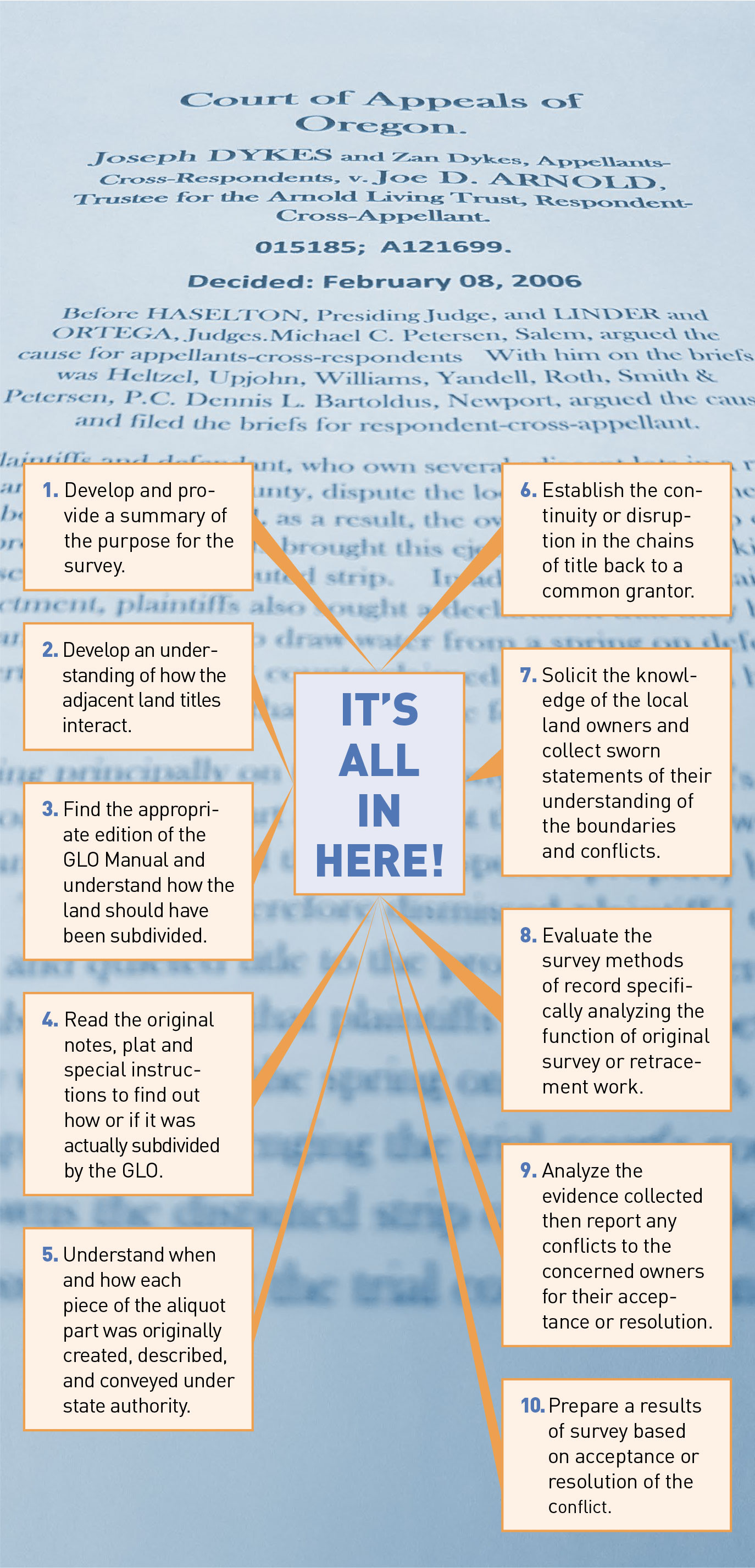 The Dykes court built an analytical outline starting with a brief summary of the complaint. Similarly we summarize our projects in our client proposals. Like the courts we don’t actually know the result until we sort through the evidence. A thorough scope of services is a great place to summarize our function and bolster the owners understanding of our role. Right up front in the scope of services the owner should be put on notice that we will not produce or record a survey until any conflict is resolved. I don’t know of any obligation that binds us to a spray and pray business model forcing us to place monuments before a project is complete. We know that notice is served through monuments, survey maps, and deeds all working in concert. Finalizing the results of the survey before setting the iron makes sense to me. So if we can’t arrive at an acceptable conclusion then there seems little benefit in polluting the public record with inconclusive evidence.
Chances are your retracement services are leading up to a sale, construction, or an argument. All of which tend to naturally set folks on their nerves. Disputes may be apparent when analyzing competing chains of title. We’ve seen a few courts do this to smoke out the conflict. The Oregon Court made a critical analysis right up front. “The two surveyors took dramatically different approaches to the task.” As time goes on the surveyor is faced with sorting out successive retracements on top of original work. The first conflict we face may be from our colleagues in the form of a pin cushion. Genuine disputes materialize from genuine ambiguity. Isolating or ruling out ambiguity among the record documents may open the door to conflict resolution before you even set foot in the field. Those pin cushions on the other hand appear to stem from “I-measure-better-than-you” syndrome and may not really be indicative of true ambiguity. I don’t know the answer to the pin-cushion effect but I’d gladly pick the one that the adjoiners agreed to…and authoritatively document any agreement or under the guidance of consul. I know you guys that do $500 surveys are cringing because half of your fee is wrapped up in monumentation and there’s no room in the budget for consul. Well, stop measuring better than me and use the monuments that are already in the ground. That should cut your bill in half, right? I promise I’ll keep my rates too high for the lawn dart competition.
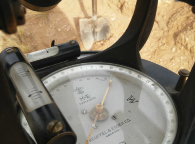
 There’s more to retracing in the PLSS than just grabbing a tax map and a deed. Understanding the federal manual in force at the time of the survey is the big picture. Recovering any special instructions to the original or controlling survey is extremely critical evidence. Furthermore the actual notes and plat are most certainly evidence accompanying the original grant so we need to toss them in our grocery cart too. Dykes v. Arnold really boils down to that third wheel in the PLSS. The odd girl out here is the subdivision of the section after the G.L.O. bailed on us. The question is who originally cut up the section and how did they do it? We are continually told by the courts that “Colonel Mustard in the conservatory with a lead pipe” is a better answer than “me and the rubber band of righteousness”. That period between the end of federal surveying and the time that the locals showed up with their pitchforks is the puberty of the PLSS. Local standards emerged as county and private surveyors were faced with the reality of further subdivision on a shoestring. In Dykes we see the locally seasoned technique of “stubbing in” the center of section. Although the standard is not addressed in the federal instructions, it was clearly defined as a standard of care in the authoritative local record sources. The court spent a lot of time examining the local standards of the day and in the end found them favorable. I have to believe that Mr. Nyhus’ pulled off a three point swish here. His thorough research, successful recovery, relevant perpetuation, and effective final presentation enabled the court to fully analyze the magnitude of the evidence. Without Nyhus’ work the court may have been looking at lopsided evidence pointing to a distasteful reconstruction of the section by the numbers. The takeaway is that the authoritative subdivision of section was historically pinpointed in the record, supported by an established standard of care, and actually recovered on the ground exactly where it was said to be. That trinity of record, standards, and marker was well played by both Nyhus and the Court.
Establishing a common grantor between competing chains of title may isolate the source of ambiguity. For starters this most likely defines whether or not we are facing simultaneous or sequential conveyances and the presence of a senior right or senior survey. The Dykes court examined “The subdivision of the southwest quarter and the first deeds referencing the center of section 12”. Understanding how those grants were originally described, marked, and conveyed, can unravel the whole PLSS schematic in a big hurry. In this case it was pointed out that “All of the lots in dispute in this case originally were part of a larger, irregularly shaped parcel in the northeast corner of the McBees’ quarter section that they conveyed to the Hazeltons in 1926. Apparently, that was the first deed to make a specific “call” to the center of section 12. The description began at “the center of section 12” and then, using metes and bounds…” So the court was able to establish a dependence on the center of section 12, wherever that might be, by sequentially created tracts. Continuing on, more evidence was uncovered in the record. “The next event of note took place in 1931…Each of the six (conveyances) identified the property being conveyed to the county through deeds that began their descriptions by references to “the center of section 12.” The location of Tomjack Road therefore was dependent on the location of the center of section 12.” So we have more dependence on the position of the center of section and these calls continue throughout the chains of title and up to the time of the dispute. We’ve stopped, dropped, and rolled on this point many-a-time and once again we are at this month’s SDR. Short of having a crystal ball into the future, someone puh-lease tell me how any of these parties were served notice of Denison’s 1997 double whammy decades before it even happened? They weren’t and we know his center was unfortunately not part of the evidence chain until he created it in 1997. Okay, so the court determined the conveyances relied on the center of section and that the land divisions are described by metes and bounds. I have to believe that the center of section referred to by the grants was the one that existed at the time of the grants, right? Nyhus crawled in a time machine and provided the court with conclusive evidence of what that center corner was at the time of the deeds.
This decision is well presented and easy to read. I encourage everyone to step back and look at the presentation of the decision. Then focus on the issues the court felt were important. I see a beautiful outline supplemented with an intense level of historic detail. The court immersed itself so deep in this case that I can’t “unsee” the bold standards they offered or separate myself from a personal obligation to run every survey through a similar analysis. Feel free to send questions or comments to rls43185@gmail.com.