
This illustration shows the land owned by David Camp at the time of his death in 1838, including an ivy covered horse stable. Illustration by Tara Hannon.
As Sandusky County prepares to celebrate its bicentennial, it seems appropriate to reflect on the work of pioneering county surveyors, those who came after federal government surveyors were done “laying out the land” of the Public Land Survey System and after Ohio became a state in 1803. This article focuses on the contribution of David Camp and how his work was essential to the growth and development of northwest Ohio, specifically Sandusky County.
The office of county surveyor was established by the first Ohio General Assembly. When a new county was created, the Common Pleas court appointed public offices, including that of the county surveyor. These appointed positions were reserved for the educated class. At the time, the duties of the county surveyor were to verify land titles and boundaries, and to establish state, county, and township roads. The Ohio State Legislature made the office of County Surveyor an elected position in 1831. The newly elected surveyor would serve a term of three years, “if he so long behaved well and until his successor is elected and qualified.”
Sandusky became a County in 1820. Ezra Williams was the first appointed County Surveyor followed by David Camp who served from 1828–1936. Camp being the only person who was first appointed and subsequently elected into this position.
David Camp was born on January 2, 1778, in Litchfield, Connecticut. He married Elizabeth Root in 1803 in Chittenden, Vermont. Together they started a family in Westford, Vermont. In 1814 the family moved to Minisink, NY. They remained there until 1822 when the Camps packed up all their belongings in teams of Oxen and headed westward to Sandusky County, Ohio. At this time Sandusky was a dark, thick overgrown forest and marshland known as the Black Swamp. The land was soaked in water, filled with wild animals and Native Americans with few good roads for travel.

This 1859 photo of the Sandusky Lighthouse (now known as Marblehead Lighthouse) shows the stone house as described in Camps 1834 field notes. A commemorative brick honoring David Camp lies on the Marblehead Lighthouse pathway. Photo courtesy of Marblehead Lighthouse Historical Society.
In 1830 President Jackson signed the Indian Removal Act, which opened up even more land for new settlers by displacing several active Indian tribes in northwest Ohio. Pioneers making the westward trek needed good roads to travel. I am reminded of the movie Field of Dreams when the Iowa corn farmer hears a voice telling him, “If you build it, they will come.” So it was with the roads in Sandusky County. Camp laid out new state, county and township roads making it possible for settlers to head west and easier for farmers to bring their crops to the market.
Little pieces of Camps work is buried and scattered, like bread crumbs, across Sandusky, Huron and Wood Counties. Digging through old county records, one can find Camp’s field notes, plats, and county commissioner journals from the 1820-1830’s, including references to physical features on the ground that are still here today. These glimpses of the past are evidence of Camp’s contribution to the growth and development of not only Sandusky County but also to Northwest Ohio.
Camp surveyed the state road from Lower Sandusky (modern day Fremont) to Findlay in 1830, as well as the Findlay to Port Clinton state road in 1831. Field notes from a 15-day survey in 1832 describe a 66-mile long public road being established from Fremont to the former Fort Defiance, which was being used as a trading post. Also, in the commissioner records are roads from Fremont to Perrysburg, home of Fort Meigs, which has been reconstructed and open to the public. Another road runs south from Fremont to Fort Seneca, a supply depot during the War of 1812. All three of these forts were used in some capacity during the War of 1812.

A 1828 survey plat shows the land of Holsey Forgerson, son-in-law of Camp.
A portion of Port Clinton Road, Muddy Creek, and a bridge appear on a survey plat in 1832 when Camp surveyed Section 30, Township 6 North, Range 16 East, Ohio 1st PM, into lots for Isaac Lathrop and Holsey Forgerson. All three features still exist. This example is one of many survey plats on file at the Sandusky County Surveyor’s Office that breaks down sections into lots for pioneers.
A 60-foot wide wide state highway that crossed three counties from Marblehead Lighthouse, on Lake Erie, goes westerly to the Maumee River. Marblehead Lighthouse was built in 1821 with an adjacent stone house for the lighthouse keeper. “Beginning at a post 50 links S.E. of the South Corner of the Stone House by the lighthouse on Rocky Point, thence by the magnetic needle,” states Camp’s field notes, which continue on to describe the 45-mile survey and ends “to a post on the East bank of the Maumee River, opposite the mouth of Swan Creek.” Since then, the stone house has been replaced with a new house built in 1880, and an additional 15 feet was added to the lighthouse. The lighthouse was featured on a US postage stamp in 1995, and is the oldest lighthouse on the Great Lakes in continuous operation to this day. In 2017 a visitor to the lighthouse donated a photo, dated 1859, to the Marblehead Lighthouse Historical Society. That photo shows the original stone house as described in Camp’s field notes. Working on Camp’s survey crew was Albert Camp (son of David Camp), Edward J. Lockwood (son of Sam Lockwood), Fulton Henderson, J. Kirpe and J. Philips.
In 1835 Camp laid out village lots on the east side of Bellevue, Ohio, creating the first village plat of the town. According to an article about the Western Reserve, early village lots were priced low with longer time periods to pay off the debt to entice people to move to the area. Today, most of the layout of Camp’s survey is still there. The public square is gone, but the roads that remain, including Main Street; appear to be the same width as originally drawn.
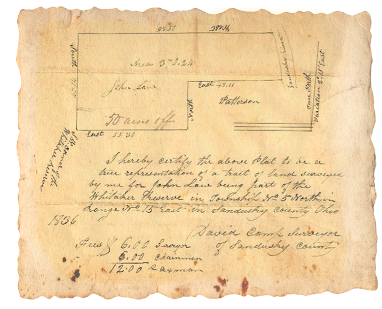
A portion of the Whitaker Reserve was surveyed by Camp in 1836. The original found on EBAY in 2016 and purchased by Sherri Barnes.
Another interesting survey plat shows a portion of the Whitaker Reserve. This original survey was found, of all places, on eBay. It is dated August 22, 1836. The survey shows the Sandusky River and the southwest corner of Whitaker Reserve. James Whittaker and his wife, Elizabeth Fulks, were both prisoners of the Wyandot Indian Tribe in Northwest Ohio. They were given 1280 acres of land which came to be known as the Whittaker Reserve. The Whittaker Reserve was part of the Treaty of Fort Meigs in 1817 and was deeded to the family by President James Monroe in 1823. Camp was paid $24.00 for this survey. Family legend indicates Camp’s wife, Elizabeth, drafted the survey plats from her husband’s field notes.
Unlike modern-day county surveyors, Camp did not receive a monthly salary. Public records and his journals show his pay for a day of surveying was $1.50. He was paid $27.00 for 18 days of work for the Marblehead Lighthouse survey in 1834. Survey crew members and viewers each earned $0.50–0.75 per day. In the 1830’s surveyors were only paid for work performed. When there was no county business to attend to, Camp took care of his family, crops, and farm.

Camps journals have been preserved and show records of his agricultural operations. This page is dated 1838. Courtesy of Scott Gould, 3x Great-Grandson of David Camp.
Camp, like many of us today, teamed up with another surveyor to do additional surveying work. He and Sam Lockwood joined forces and created “Lockwood & Camp.” Lockwood was a well-known surveyor in neighboring Ottawa County. Camp kept records of business in his journals. In March 15, 1835 they paid Albert Camp (son of David Camp) for 6 days of survey work and for making a trip to file a survey at the General Land Office in Bucyrus, Ohio.
Sandusky County Commissioner records describe Camps field notes and plats. One such example requesting a road survey reads as follows:” The inhabitants of the County Township petition the Commissioners and pray for a county road to establish commerce on the county line between Huron & Sandusky” The roadway would be surveyed and then read publicly in an open meeting with the commissioners.
In addition to his county surveyor position, Camp held other public offices including that of county commissioner, assessor, and from time to time he stood in as justice of the peace. He served with more famous Sandusky County pioneers such as Israel Harrington and Jesse Olmsted. In 1833 he helped establish the local Presbyterian Church and served as one of the first elders. He was also part of the Whig Party and attended the Whig Party Convention at Fort Seneca in 1836.
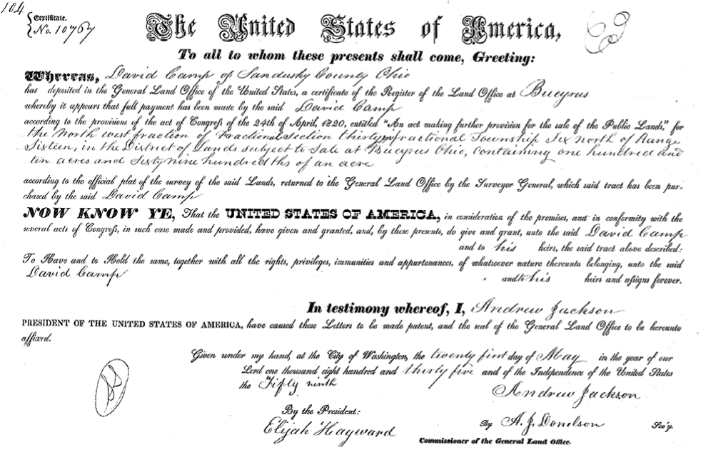
David Camp land patent dated 1835. Land patents like this one can be found online at: http:/glorecords.blm.gov
The Camp’s endured all the hardships and trials that come to early settlers. They participated actively to ensure that growth progressed. At the time of his death in 1838, Camp owned five parcels of land totaling a little over 172 acres, including an ivy-covered horse stable that once stood at the corners of County Road 145 and North State Route 53 in Fremont, Ohio. After his death, his survey crew helped Mrs. Camp finish his work, drafting plats from his field notes. He is buried at Whittlesey Cemetery in downtown Fremont, Ohio. His headstone lies in a pile, along with that of other pioneer headstones.
David Camp left his mark on Ohio where glimpses of his work can be seen today, almost 200 years later. The work of those early pioneering surveyors, whose names are all but forgotten, was essential to the growth and development of Ohio. Andro Linklater, the author of the book Measuring America, once asked, “Which came first, the pioneers or the surveyors?” Luckily, for Northwest Ohio; David Camp was both.
Sherri Lee Barnes has worked in the surveying industry for over 33 years. She last appeard in the January 2017 issue where she wrote about the history of surveying the Colorado River Aqueduct. She is the 4x’s great-granddaughter of David Camp.