Click on the map for an enlarged version. Scroll to the bottom of the article for links to massively enlarged versions of the map and plat.
Several years ago I wrote to The American Surveyor and asked old man Cheves why, if double proportioning is a last resort, is it one of the first things a surveyor is taught? In fact, it takes less time for me to implement this federally inspired recipe for disaster and wreak havoc all across private lands than it does to lawfully apply for a special recreation permit to access the federal lands for which it was intended. The courts have continually rejected the method as a substitute for original evidence. That leads us to Oregon and the case of Dykes v. Arnold.
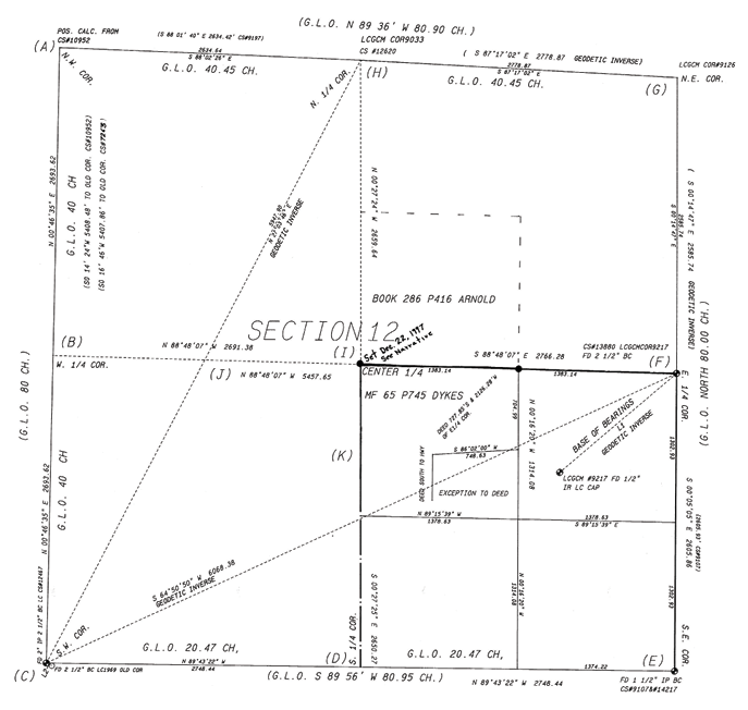
The court didn’t lollygag around and quickly set the scene with “The two surveyors took dramatically different approaches to the task.” In a nutshell, we have a proper boundary retracement survey competing against an unauthorized re-subdivision survey a.k.a. double proportion. The court summed up the proper retracement like this “Defendant’s surveyor, Nyhus, aware that the center had been surveyed and marked (“monumented”) in 1899 by the Lincoln County Surveyor, attempted to locate the center as set by that survey. He believed that he succeeded and that the section’s center, as set in 1899 by the county surveyor, Derrick, coincided with the accepted boundary lines in the area as reflected by the deeds, county road location, fence lines, and lines of occupation of the last 100 years”. The court’s wording sounds so symphonic to me. It’s almost as if they were all surveyors. The court further describes the unauthorized re-subdivision of section like this “Plaintiffs’ surveyor, Denison, made no effort to retrace that prior survey because he thought it was flawed in its methodology. He therefore set out to locate the center anew, using the legally prescribed methodology and modern survey techniques and disregarding any evidence of the boundaries as reflected in the deeds, fence lines, county road location, and lines of occupation.” That’s my emphasis added to the part where we see the unauthorized subdivision originate.
The court lays down a sequence of events surrounding the chain of title. “The first grant of land in section 12 to private ownership was made in 1876. The GLO conveyed the full southwest quarter of the section…to Eugene Adams. The conveyance described the land as the “South West quarter of Section Twelve” according to “the official plat…(also) In 1876, the southeast quarter was conveyed to Thomas Adams. Eugene Adams evidently conveyed…the southwest quarter to C.H. Williams sometime before 1897. Then, in 1897, C.H. Williams conveyed…the “southwest quarter” to David H. Williams…in April 1899, the Lincoln County Surveyor, Z.M. Derrick, performed what is the first recorded survey of the interior of section 12.” So we have both the southwest and southeast quarters described in conveyances but the common corner apparently had not been established on the ground until a few decades later.
Chad Erickson covered this case for The American Surveyor a few years back. This initiated some debate between Chad and a reader named Steven Patterson who at the time was a first year law student and LSIT. His education enabled him to provide some legally solid insight and judicially joust with Erickson. The exchange was well founded and just good old fashioned fun to watch. Well, we’re not lawyer folk and we’re not going there with Dykes. Instead, we’re gonna look directly at the competing surveys and smoke the polecats out from under the porch.
Charles Denison (1929-2010) was a good Surveyor. It’s apparent from his work. He was precise, thorough, and refined. He was working for Dykes and was familiar with the history and area. He describes a few wounds on his survey that could fester up and gangrene without immediate attention…and sure enough they did in the form of a lawsuit. In the thick of battle we sometimes don’t realize these symptoms until it’s too late but in hindsight we have in front of us some major SDRs (stop, drop, and roll). Chuck’s narrative describes “The position for the new west one quarter was calculated by proportionate measurement, for the subdivision off the section…” Whoooaaa there, a “new” west one quarter? Where’s that coming from and what’s wrong with the existing one? Feeling the need to re-do existing work should be more unnerving than relieving. Furthermore, why would a contemporary surveyor need to subdivide the section in the first place? It was already subdivided by deeds and various surveys. We are now looking for evidence of how those conveyances were laid down, so ask yourself “is the corner evidence effective with those conveyances?” The pie has already been cut; the real question is “how and where?”
Another SDR pops up as the statement continues. Just to clarify I have broken Chuck’s statement and inserted my comments right at the itchy spots. Continuing on “… as the monument set by C.S. #7263 was proportioned from the erroneous position of the southwest corner.” This highlights the tawdry exercise of stacking proportionate restoration on common law corners in the non-federal arena. If the first ring dinger wasn’t good enough how is a “re-bubbling” going to be any better? Common law narrows retracement toward the observation of existing evidence. Introducing an alternate or unnoticed position is contrary to that charge. Ask yourself “has anyone ever had the opportunity to actually rely on my newly created position?”
Geodesy can be the Salem Witch Trial of retracement surveying. Accusing a corner of being at some intangible computed position is like Elizabeth Hubbard screaming “witch” and the courts relying on the misguided science of drowning as evidence. “The positions of the northeast corner, and the north one quarter corner were computed from geodetic inverse of published L.C.G.C.M. coordinates.” Geodetic computations and inverses are theoretical and do not serve notice to landowners without marks. Ask yourself “what opportunities did the witnesses have to understand this position?”
Chuck continues his concerns with “The position of the south one quarter corner was proportioned as in previous surveys.” Okay? What evidence do we have to tie the position reliably to a conveyance? We know that the southwest corner was erroneously pinned to alternating positions. The rubber band of righteousness has just snapped under the instability of southwest corner. There is a period of time when conveyances and surveys could have relied on either position of the southwest corner. I am breathing uneasy and think it’s time to SDR.
Despite all of the witchcraft, science, and geodesy that aristocrats might call “learned measure”, common property owners have an understanding of their boundaries and an obligation to defend them. Denison was rammed, then spun out and hit the wall in turn number four as noted in his final statement. “Survey as of this date has set the C.E. 1/16th corner but crew was unable to set the center ¼ corner, ties to fence lines, or search for evidence of the center ¼ corner, as person representing himself as owner to the north demanded that the crew leave and pulled out the stakes and survey control monuments which were established to set the center ¼ corner.” Something is grossly wrong here. These owners might just be tabacky chewin’ moonshine crazed hill folk thinkin’ you’re a revenuer man but these folks might also actually know something you don’t. There’s a good chance that their knowledge and standing trumps a double whammy in the hierarchy of precedence. Furthermore ignoring their challenge seems like a denial of their opportunity to disclose evidence to your client.
Denison did a thorough job and the survey itself is extremely retraceable. There’s plenty of solid measurements and calls for monuments. His research was deep and cleanly incorporated with record references. The methods leading to his decisions are clearly expressed in his narrative and notes. So how can something this good not win in court? I think the court identified it best with “Denison made no effort to retrace that prior survey because he thought it was flawed in its methodology.” It’s apparent to me that Chuck did his best to make things work according to the B.L.M. rules and standards he was taught. Unfortunately the prior surveyors employed alternate methods that ripened and an honestly mistaken bearing tree at the southwest corner of the section didn’t help matters either. I encourage everyone to pay their respects to Chuck Denison as a good surveyor and visit his obituary at https://bit.ly/2Fo1q5w
Next month we’ll breakdown the Nyhus survey and see what groceries we can bag. Gary Nyhus is alive, kickin’ and still dangling his bob in the Oregon sea breeze. He mentioned one of his great mentors around Lincoln County, Oregon, by name and asked if I might know of an old surveyor named Robert Dahl? That’s like asking if I’ve ever heard of a band called “The Beatles,” right? Feel free to drop me a line at rls43185@gmail.com.
SELF-STUDY GUIDE (References)
Google the following search terms to find the article references:
- Dykes v. Arnold 015185; a121699 Oregon
- Wirostek v. Johnson, 266 Or. 72, 75,
511 P.2d 373 - Reed v. Tacoma Bldg & Sav. Ass’n, 2 Wash.198, 202,26P. 252, 252-253
- McDowell v. Carothers, 75 Or. 126, 135, 146 P 800
- ORS 93.310
- Mason v. United States 260 U.S. 545, 558, 43, S. Ct. 200, 67 L. Ed 396. (This ties to footnote 14 in Dykes decision).
The Barbershop Barrister
So when should I use double bubbling? My guess is close to never in the course of a retracement survey and even closer if your paycheck is not from the U.S. Treasury. Pulling a double whammy in the federal sandbox is appropriate and a good answer to an anomaly that exists under federal authority. The method is an equitable redistribution of measurements provided under a consistent set of instructions and it’s an ingenious solution within a collective domain.
On the other hand a successful boundary retracement in the non-federal arena must reconcile the evidence of conveyances to be effective. Retracement includes perpetuating evidence that marks the boundaries of competing chains of titles. Notice of a deed or patent is related with marks often established by independent parties. This could include discovering evidence leading to a reasonable construction* of their connection. Why doesn’t double bubbling fit here? Because your fresh double dinger is a remedy, not evidence ya’ nitwit. A lost corner is rare and is the conclusion of a retracement survey. After that conclusion is made, an authoritative action must take place to resolve the private ownership issue and restore the public reliability of the corner. I would not expect a land survey alone to satisfy either or both needs. However, and I’ll give you double troublers some credit for this, winging by the numbers out across the lily fields of harmony has served to smoke out some good testimony in the courtroom. Look what we found in Boerst (Wisconsin), Atwell (Washington), Wacker (Arizona), Tresemer (New Mexico), Lee (Alaska), Dittrich (Minnesota), and of course Dykes in Oregon.
Again, so when should I use the double proration method? My best answer is probably when preparing a recorded boundary agreement in the absence of any evidence or agreement between owners and with authoritative notice deeming the original corner as lost. When I say “authoritative notice” I’m not just talking about your note on your survey. At this point we may be dealing with a formal mitigation, perhaps soliciting the public for evidence through formal advertising, deposing experts, and maybe even petitioning your county or court on behalf of the public. There’s more to it than tossing out a rectangular grenade and walking away. That’s just domestic terrorism with a COGO dirty bomb. Our value lies in recovering evidence that satisfies a reasonable construction* to the interested public.
So I’ve asterisked “reasonable construction” because I don’t want any confusion with any defined legal standard of care. It’s a homespun phrase used in this article to describe our subjective judgement. On that topic and using the corner record from the Dykes survey: archive.amerisurv.com/PDF/MON_PED.pdf
- Does the evidence lead to a reasonable construction of the position of the section corner?
- How many different positions were accepted as the corner?
- Does the record lead the interested public to reasonable notice of the original position?
- Could the record lead to a reasonable construction of otherwise valid or bona fide corners in alternate places throughout the section?
See full-size images at:
archive.amerisurv.com/docs/P1j.jpg
archive.amerisurv.com/docs/P2j.jpg