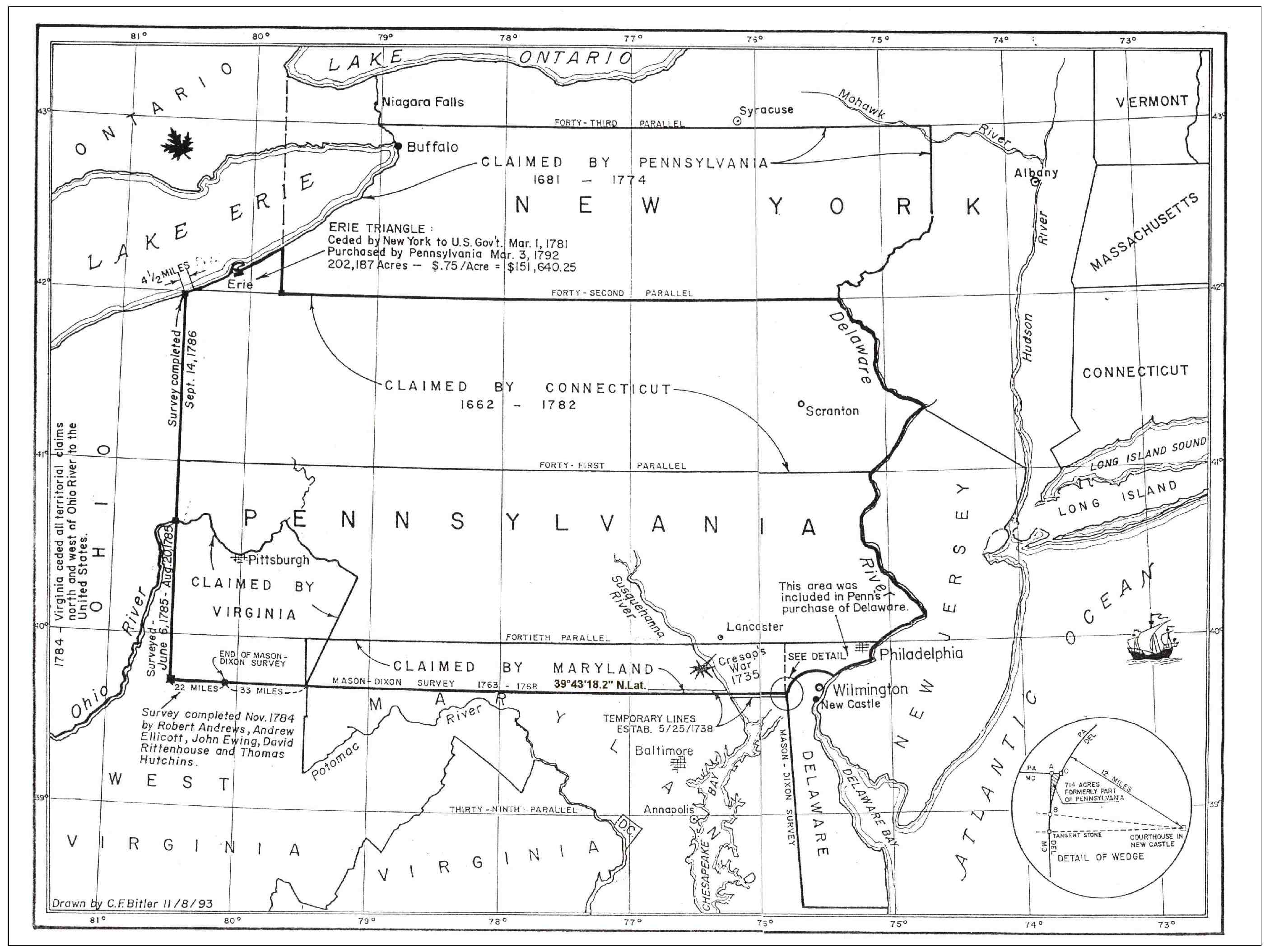
Click on map for a larger version
Latitudes and Longitudes
This most clever and informative map was drawn in 1993 by Charles F. Bitler, Jr., a Pennsylvania Professional Land Surveyor. The present-day Commonwealth of Pennsylvania, to include both its actual and its claimed provincial boundaries dating from the late-1600’s, was Mr. Bitler’s main interest and is the centerpiece of his map. Little is known about what geographic and cartographic resources he used but, as befits a master craftsman, his map is not only visually pleasing and intellectually enlightening but is precise, accurate and to-scale as well. Please pay close attention to each of the East-West Lines of North Latitude (called Parallels because they are parallel with the Equator). These are shown in 1° angular increments northward from the Equator, using the center of the Earth as the radius point (3,960± miles radius). Also not to be neglected are the North-South 1° angular-increment lines, known as degrees of West Longitude, referenced to 0° at Greenwich, England, and continuing for 180° around the Earth’s surface, an oblate-spheroid shape. Because our Earth is a globe, the spaces between Longitude lines are widest at the equator (60 miles), converging to zero width at each Pole. Notice further that, even though they are curving as all lines of latitude do, Mr. Bitler’s Lines of North Latitude are parallel (or concentric) with each other. At the same time, all of the Lines of West Longitude except for the center one of 77° (Mr. Bitler’s personal cartographic discretion) are noticeably non-parallel with Mr. Bitler’s vertical marginal lines along the left and right lines of the paper. For example, notice that the Lines of 73° West Longitude and 81° West Longitude are not vertical but are converging toward the unseen North Pole.
Pennsylvania and its neighbors
The Bitler Map encompasses a large portion of the northeastern States, to include all of Pennsylvania, New Jersey and Delaware, as well as most of Maryland and portions of Connecticut, Massachusetts, Vermont, New York, Ohio, Virginia, [present-day] West Virginia and Ontario, Canada. It also shows the location of several major cities, including Philadelphia and the 10-mile square of Washington, D.C. The Province of Delaware’s northern property line is the only arc-boundary (12-mile radius from the spire of the New Castle courthouse) in the United States, discounting the portions of the huge-radii of the natural curves of various Lines of Latitude that have been used as many States’ boundaries. Mr. Bitler has thoughtfully provided an inset detail of the famous “Wedge” at Maryland’s northeastern corner. This factual discrepancy (and its accompanying smaller one) was revealed in 1764 by a direct result of the application of the mathematics and measurements of Charles Mason and Jeremiah Dixon to the erroneous planning of the early Proprietors. Pennsylvania ultimately ceded the 714 acres of the “Wedge” to the United States for the purpose of transferring title to Delaware.
“My kingdom for a [survey map].”
Prior to 1682, the founding Proprietor of Pennsylvania William Penn was active and instrumental in provincial development and growth, having helped to establish some Quaker communities in the Duke of York’s Province of New Jersey. This friend of William Penn, the same Duke of York who later became King James II, also wrested by military force New Amsterdam (later known as New York City), as well as the lands he called Delaware from the Dutch and the Swedes, lands that had 50 years before been chartered to the Calverts of Maryland. Soon thereafter, William Penn acquired these lands by leasing the “Three Lower Counties [Newcastle, Kent and Sussex] of Pennsylvania”, designated Delaware by its new owner, the Duke of York, who later re-acquired it from the Penns. If you take note of nothing else from your study of Mr. Bitler’s map, mark it down that throughout this whole colonial period, indeed, throughout man’s history, precise and accurate survey maps have been (and still are) indispensable for planning and development. Plans and fortunes can rise or fall by the use of or by the lack of them. Beware of visually pleasing but inaccurate substitutes!
Access to water
As you continue to study the Bitler Map, you will see or at least surmise that Provinces other than Pennsylvania already had the crucial advantages of two-way access to the Atlantic Ocean for (1) receiving supplies for provincial sustenance and development and (2) shipping taxable goods needed by England. Therefore, one might begin to understand some of the possible reasons behind the Penn family’s prodigious and unrelenting efforts to acquire frontage on major trade shipping routes. After all, as you can see, Pennsylvania was a Province which, as far as direct ocean access was concerned, was essentially “land-locked”. This was a reason that the lands which became known as Pennsylvania were not chartered earlier than 1682.
Rivers and ships
Mr. Bitler shows six major rivers, namely, the Potomac, the Susquehanna, the Delaware, the Ohio, the Hudson and the Mohawk, as well as portions of the Atlantic Ocean and two of the Great Lakes, Erie and Ontario. The two major bays or estuaries, the Chesapeake Bay and the Delaware Bay, were navigable. However, the Delaware River was not passable to ocean-going ships, at least north of the 40th Parallel; neither was the Susquehanna. Therefore Penn seems to have situated his capital city of Philadelphia where he did, across his Charter’s southern boundary (his property line, if you will) on the lands of the Calverts, because of the river’s navigational limits.
Lake Erie
Land Surveyors and other mapping explorers had already reported to the Penns that their northern boundary (or property line) did not reach Lake Erie. Undaunted by the fact that their Charter specified the Province’s northern boundary at 2 degrees of North Latitude northward from the 40th Parallel, the Penns claimed all the lands up to 3 degrees, namely the 43rd Parallel, likely because they also wanted access to Lake Erie’s commercial potential. As it turned out when the marking of the west boundary meridian line was completed in 1786, the accurate surveying revealed that the Province actually did own a very small piece of lake frontage.
Just because your Charter says…
The northwestern portion of the Province of Virginia was defined by large land grants, among them the Fairfax grant. Since the original grant language specified the Ohio River as a western boundary, Virginia naturally claimed the lands along the Ohio for nearly the entire reach of the river. However, in 1750 when the Chancery Court of England rendered its verdict on the Penn-Calvert dispute to be in favor of the plaintiff Penn, Virginia realized that they were politically and legally “outgunned”. So they had no choice but to acquiesce to Pennsylvania’s new southern boundary (39°43’18.2” North Latitude) as it extended to the 80-1/2° West Longitude meridian. Since the court decision legally sanctioned the Penn’s to take a 19+ mile wide, 196-mile long strip of Maryland’s original charter, the Province of Virginia had to acquiesce to losing a huge area of their claim also.
What do you think it’s worth?
Someone has said that a picture is worth a thousand words. There are more than thirteen hundred in this little commentary. After assessing Mr. Bitler’s Map in the light of how it has helped your own grasp of a little of the early history of these great States, how many words do you think that it’s worth?
About the map’s creator
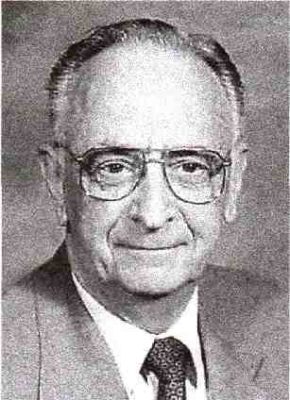 This most clever and informative map was drawn in 1993 by Charles F. Bitler, Jr. (1927-2014), a Pennsylvania Licensed Land Surveyor. Mr. Bitler conceived and designed his map to illustrate his talks at seminars and at Mason and Dixon celebration events. He was a charter member of the Mason-Dixon Line Preservation Partnership (MDLPP), working with Todd Babcock, the Partnership’s founder. Charlie graduated from Penn State University, where he received his Professional Land Surveyor’s certificate, and from Lancaster Bible College. The majority of his professional work was for Huth Engineers in Lancaster, receiving recognition for his work from Lancaster Township. A U.S. Army veteran, he was also an oils-and-water-colors artist. He was deeply interested in helping to develop young people, donating his surveying skills and teaching time to many Bible camp programs. A man worth knowing. Thank you, Charlie!
