Juniper Systems Releases New Cedar CP3 Rugged Smartphone
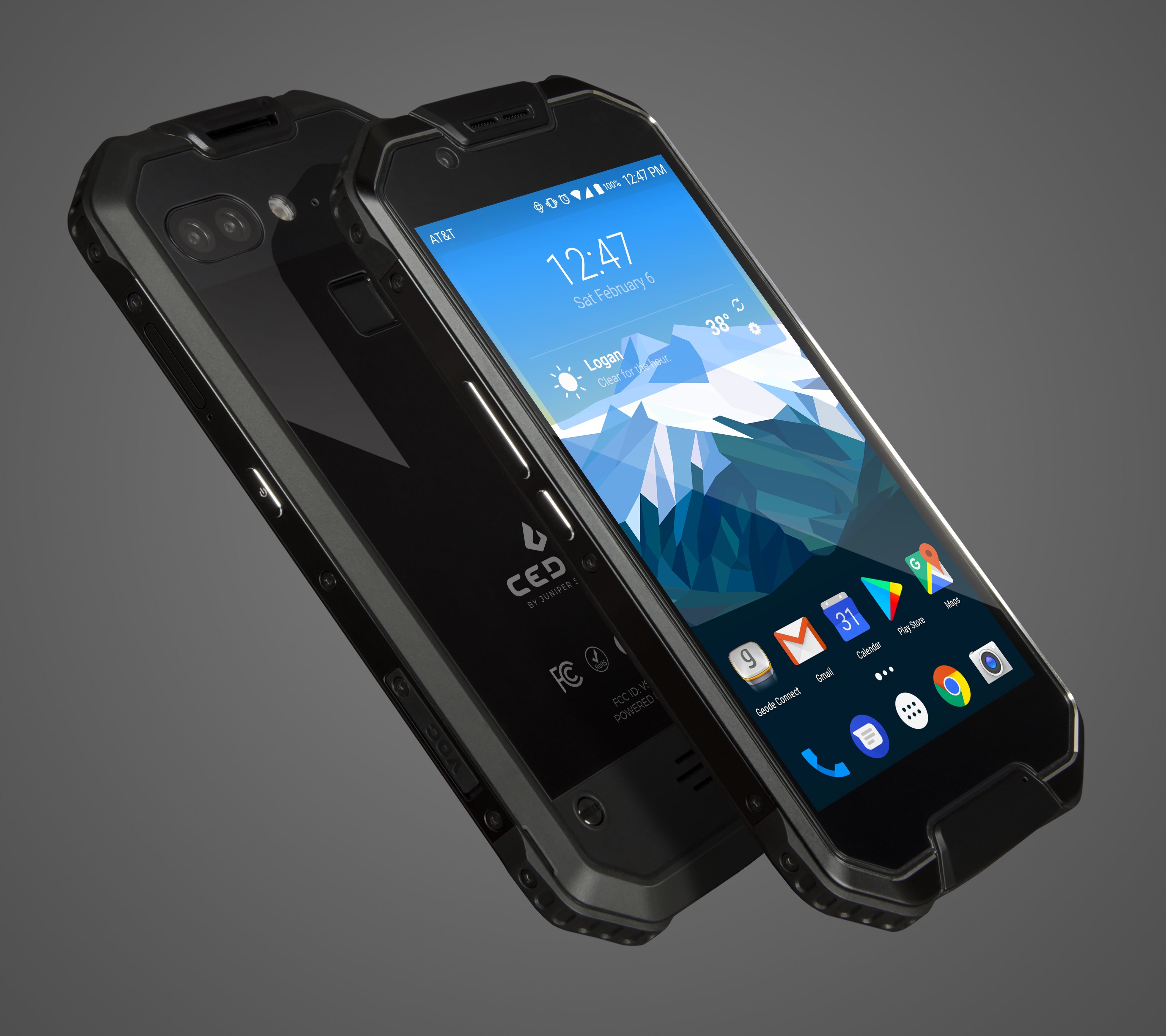 Juniper Systems announced today the release of its newest Cedar device, the Cedar CP3 Rugged Smartphone™.
The rugged smartphone comes two years after its predecessor, the CT5 Rugged Handheld™, and brings with it massive upgrades to nearly every specification. The CP3 touts a 14- to16-hour battery life operating at full brightness and running GPS; a 16-megapixel user-facing camera and dual 12-megapixel rear camera; a bright, high-resolution AMOLED display; and 6 gigabytes RAM with 64 gigabytes of internal storage.
The CP3 is powered by a Snapdragon 653 octa-core processor. The processor delivers fast load times and top-tier performance for advanced tasks without draining the battery.
“Rugged doesn’t have to mean bulky and slow,” said Cody Draper, Juniper Systems’ Cedar product manager. “The CP3 shows that smartphones can be purpose-built for data collection in the world’s toughest environments—and scrolling through Facebook at home. It is lightning-fast, slim, and tough as nails and we are really excited to get it into peoples’ pockets.”
Like the entire Cedar product line, the CP3 is dustproof, waterproof, and shockproof. It is rated IP68 and certified to withstand 1.5 meters of water for 30 minutes. In addition, the CP3 can operate in both blazing hot and freezing cold temperatures—from -22 to 140 degrees Fahrenheit.
The CP3 boast amenities unique to rugged devices like fingerprint ID, USB type C, and it supports Google’s suite of popular apps with Google Mobile Services. The Cedar CP3 includes year-long customer service and support from Juniper Systems.
“Cedar products are affordable and field-tested every day by hardworking professionals,” Juniper Systems CEO DeVon Labrum said. “This phone certainly is no exception.”
“The CP3 makes light work of heavy tasks,” he added. “I think users are really going to like it.”
The CP3 is available globally and works on any GSM network.
Carlson Survey 2019 Brings User Requested Features and DGN Compatibility
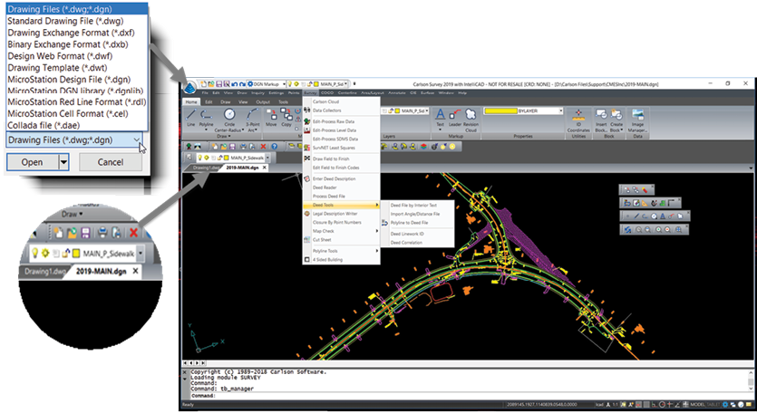 Carlson’s latest release of Survey 2019 brings more user requested features as well as enhanced compatibility between CAD platforms.
Carlson Survey with IntelliCAD 9.0 supports direct read of DGN files allowing users to make edits without converting drawing formats. Surveyors who work with clients that require DGN as a deliverable can complete projects while staying in the familiar IntelliCAD interface. While not all Carlson commands are yet supported, this latest release includes much of the basic CAD draw and edits commands as well as a large collection of Carlson commands, including points, annotations, centerlines, surface grading, and Field to Finish. This benefits surveyors who are required to cross
CAD platforms.
“Users who enjoy the benefits of customizing their workspace to create an environment that enhances their efficiency and improves day-to-day work flow will be very pleased with the new features afforded in IntelliCAD 9.0,” says Doug Aaberg, Carlson Survey product manager. “Not only does the new CUI allow for more robust customization, but it is also more compatible. You can now create and share custom toolbars, ribbons, and menus across platforms such as AutoCAD.”
New features include:
- Drag and drop CUI interface
- Tool palettes that can be easily customized
- Workspaces that can be saved and shared across platforms
- Toolbars that can be imported and exported between AutoCAD and IntelliCAD
- Button Icons support of .dll, .bmp and .png formats
- Compatible macro syntax
Carlson Survey 2019 can directly export a DWG that contains Civil 3D object points, centerlines, and surfaces and can also read in profile styles and pipes. Other new features include everyday work flow enhancements such as tracking changes in RW5 files, directly storing GIS data to a CRDB file, and a brand new transparent PI entity snap override plus greatly improved handling of text and Mtext.
Carlson Survey 2019 comes with IntelliCAD 9.0 embedded and works with AutoCAD® versions 2019 to 2010. Carlson Survey 2019 can also be purchased with AutoCAD 2019 embedded. This release of IntelliCAD includes native support for DGN drawings, allowing users to work directly with MicroStation drawings without the need for export/import. Other features of IntelliCAD 9.0 include an improved dialog for customizing the user interface and the addition of tool palletes, allowing you to truly tailor your CAD experience to meet your needs.
For more information about Carlson Survey 2019 or to request a demo visit www.carlsonsw.com/solutions/land-survey/
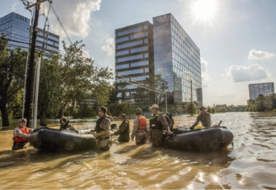
Dewberry to Perform Data Analytics for City of Houston
 Data collection and analysis will support disaster-related projections and planning
Dewberry, a privately held professional services firm, has been selected as a consultant to Civis Analytics to perform comprehensive data analytics, including flood hazard and property loss modeling and damage estimation, to support the City of Houston’s post-Hurricane Harvey recovery efforts.
The granular, structure-level understanding of this catastrophic flooding event will be critically important to the city’s efforts to catalog impacts and direct resources to the rebuilding and recovery efforts.
The resulting data will be made accessible to authenticated city staff and non-profit organizations through the new Houston Estimation and Analysis of Loss (HEAL) platform. A cloud-based system that will be used in disaster mitigation planning, HEAL will aggregate data, analytics, tools, and visualizations in a web-based environment available to city, state, and federal officials and other stakeholders.
The data development effort featured a hindcast model of the historic Hurricane Harvey storm event, which dropped 51 inches of rainfall within the city of Houston and surrounding areas over five days in August 2017. The HEAL platform will provide the city with a comprehensive data collection and analytical architecture with the ability to calculate and report unmet needs at various levels, such as structure, parcel, and census block.
The analytics will include extensive modeling to estimate flood depth and extent and the structural and contents losses created by it. Model validation will use a wide set of data from debris removal pickup locations, and community field data collection, to federal assistance information, as well as non-traditional sources such as social media videos.
For this complex project, Dewberry’s innovative approach has involved strong applications of science and engineering including meteorological data processing, 2D flood risk modeling, and damage assessment to replicate post-Harvey conditions in Houston.
FARO and STORMBEE Partner to Optimize Traceable Construction
Breakthrough Wide Area 3D Scanning Solution
FARO, the world’s most trusted source for 3D measurement and imaging solutions for Construction BIM and STORMBEE®, a pioneer in Mobile UAV technology, have partnered to offer an integrated, cost effective airborne 3D scanning solution specifically designed to optimize on-site capturing workflows as part of FARO’s Traceable Construction™. This integrated solution includes the best in class FARO Focus laser scanner and the STORMBEE S series UAV and BEEFLEX software suite.
Enhanced Productivity
The FARO – STORMBEE airborne solution enables wide area scanning missions, such as highway or train infrastructure, large construction sites and buildings as well as open pit mines. While these would take days when scanned from the ground, they can now be completed in just hours without interrupting traffic on in process construction work. Additionally, this airborne solution further enhances productivity by allowing users to capture complex environments, such as factories, chemical plants or other infrastructure features inaccessible to ground based scanning, from the air with exceptional levels of accuracy and detail and create as-built drawings, isometrics and facilitate analysis. The data can then download to FARO BuildIT Construction software to monitor construction quality control and progress or to easily create as-built CAD models with FARO As-Built Suite.
Optimized Resource Deployment
The user-friendly BEEFLEX software allows users to create centimeter level accurate point clouds directly from the in-flight data. Furthermore, the intuitive user interface assures that just about anyone can become a viable “expert” with no more than one hour of hands on training. Finally, BEEFLEX data can be exported directly into FARO SCENE software for further analysis and/or to combine aerial scans with the detail rich data from terrestrial scanners.
“STORMBEE has developed and validated its UAV credibility from real life testing in the most rigorous environments” explains Liesbeth Buyck, CEO of STORMBEE“. As a result, we are confident that this turnkey solution, that includes the STORMBEE UAV and the FARO Focus laser scanner, creates a new reliability and quality benchmark for airborne 3D data capture solutions”.
“FARO pioneered the Traceable Construction™ end to end value concept and continues to innovate the construction industry by optimizing end user experience and value”, states Andreas Gerster Vice President FARO Construction BIM. “With the combination of the unique competencies of FARO and STORMBEE, we are now able to drive a new level of time and cost effectiveness for wide area 3D data capture for large construction projects or projects where terrestrial based scanning is not the most viable option”.
For more information: constructionbim.faro.com/en/traceable-construction/on-site-capture/