A glance at the PLSS through the GIS layers looks like there is a tidy G.L.O. record interpretation, the people’s catawampus but acquiesed interpretatation, and the appellate court’s de-laminated interpretation. Holy Jefferson! How did we end up here?
We are still in Butternut, Wisconsin, looking for answers in Boerst v. Opperman. This month we need to really dive in and tear apart the Supreme Court’s decision. There are many references and footnotes that are worthy of a strong peek. The subject opinion was filed February 3rd, 2011, with a notice that the opinion is subject to further editing and modification: https://amerisurv.com/PDF/BoerstVersusOpperman.pdf. If anyone has a revised version by all means send it my way and we’ll get it out on the laundry line. Good survey practice says to dig up every piece of evidence you can find till your shovel breaks, and then yield your results to better evidence when the next guy shows up with a backhoe. The same rules apply here in Decided Guidance folks.
I have a 1957 Fourth Edition Black’s Law Dictionary printed in 1968. It’s a little out of date, so according to that math I am too, along with that 1968 Yenko Super Camaro down at the Barrett-Jackson Auction, but nobody’s complaining about it being 50 years old. Sheesh! Well anyway, I might be bending the rules a little bit because I found a definition that I feel really fits this case. It’s not contemporary and it might not be circa with the case. However, I suspect the term “amicus curiae” has been relatively stable in my lifetime, but if anybody has any heartburn with it, just give us a shout. We’ll gladly offer up your comments and right the ship. So here we go: I’m cherry picking this tertiary phrasing of amicus curiae: “Implies friendly intervention of counsel to remind court of legal matter which has escaped its notice, and regarding which it appears to be in danger of going wrong.” I am under the impression that the obliterated corner question “had escaped” the Supreme Court’s notice in the final appeal and the appellate court’s reversal on the same “obliterated” question appeared “to be in danger of going wrong”. A glance at the local GIS parcel layer may make ya’ think we’re too late on the “going wrong” part. Regardless, that’s just my speculation and it will take somebody that actually knows to explain the mechanics of this amicus curiae. The brief was filed by the Wisconsin Realtors Association so put that in your pipe and smoke it the next time you sour mouth one of their bad apples. Realtors are influential as a united voice and it looks like they may have gone to bat for the rope stretchers on this one.
Right out of the box the Supreme Court rules out adverse possession. “…neither party is asserting adverse possession…We therefore do not review the present case as an adverse possession case”. Okay, that’s gone and disengages Wis. Stat. §893.25 from the issue. I read the adverse possession statutes and felt like the Wisconsin legislature really overstuffed the bratwurst by attempting to resolve every possible boundary dispute through code. I could go on like Iron Butterfly with a self-appointed Inna-gadda-da-vida-twenty minute guitar solo rant about the dangers of over codifying boundary law but the Supreme Court neatly took the liberty of avoiding that slippery slope as we’ve already seen. I point this out because I suspect the circuit court got hung up in the statutes after the findings of fact led us in another direction.
Next, the parties and amicus curiae provided the Supreme Court with six commonly used pigeon holes that might fit this case. Interestingly enough, the supreme court runs a disclaimer “… <they> included a number of the more commonly used formulations to illustrate the language used in our case law to resolve boundary disputes and the historic inability of the court to consistently classify boundary disputes into doctrinal categories”. It sounds to me like boundary disputes are anything but the fast food taco of jurisprudence and require a higher level of professional attention. So if you really want to know why we’re licensed think about that statement for a moment.
In the supreme appeal Boerst contends that the legal doctrine of acquiescence does not apply. The argument hangs on Pickett v. Nelson in that acquiescence applies only when a party proves (1) genuine uncertainty about the boundary line that cannot be resolved; (2) a dispute or controversy concerning the line; and (3) an agreement that resolves the dispute. Now let’s dial the flux capacitor to 88 mph and go way back to 1917. While our doughboys were “over there” sorting out the boundary disputes of the European Aristocracies, the folks in Butternut also had some genuine uncertainty about the boundary line that could not be resolved, and a dispute or controversy concerning the line, and an agreement that resolves the dispute. The 1917 court stated “…the parties stipulated that the common corner of Sections…was at the intersection of the centerline…setting Henn Road as the boundary between Sections 5 and 8”. Sounds to me like Boerst’s assertion of “Pickett” was already defeated in 1917. Just for the record Pickett v. Nelson 71 Wis. 542, 546, 37 N.W. 836 was decided about three decades before our 1917 case.
The Supreme Court annotated references to help us distinguish how acquiescence is a flexible term in law. There are two concepts in play. The first is based on the way that folks behave with respect to an object or idea. This leads a court to consider that the best evidence of a line might just fall where the conduct of the neighbors has naturally placed it. The supreme court’s footnote (20) directs us to “Establishment of Boundary Line by Oral Agreement or Acquiescence” and “James O. Pearson, Annotation, Fence as a Factor in Fixing Location of a Boundary Line” both referenced in American Law Report . The second concept is a legally structured standard of care and is known as “the doctrine of boundary by acquiescence.” Two references are cited in the footnote including Clark on Surveying and Boundaries (1998) and “Unification of doctrines of Adverse Possession and Practical Locations in the Establishment of Boundaries, 78 Neb. L. Rev. 1, 11-15”. The circuit court used “acquiescence” as extrinsic evidence and relied on folks behavior to determine the line, but “The circuit court appears to have also concluded that the legal doctrine of acquiescence is applicable in the present case because the boundary line is in dispute and cannot be determined by the legal description in the deed”. Boerst contends “that the deed is unambiguous and therefore extrinsic evidence should not have been used to determine the boundary line.”
The Supreme Court concluded that the case “…most closely approximates and is governed by the principles set forth in boundary dispute cases in which a survey is in conflict with a longstanding landmark.” The court arrived at that conclusion based on their observation that “The concept of acquiescence in the evidentiary sense is often used in cases resolving conflicts between a landmark and a survey. We therefore turn to this line of cases.” The court boiled it down to owners accepting a landmark for a substantial period, a survey conflicting with the landmark, and although these landmarks commonly are fences they can be anything including Henn Road. So the court is simply looking at case law where surveys and fences tangle. The Supreme Court shares the procedure for examining a survey vs. fence case and the expected behavior of an appellate court. “In the survey/fence cases, a circuit court first determines whether the boundary line can be determined from the deed and original monuments or markers. If the boundary line cannot be so determined, the circuit court looks to the best evidence of the boundary line. The circuit court’s determination of the best evidence locating the boundary line in the survey/fence cases is essentially a finding of fact. An appellate court does not set aside findings of fact unless they are clearly erroneous. Wis. Stat. § 805.17(2).”
The Supreme Court goes on to cite Welton v. Poynter, 96 Wis. 346, 71 N.W. 597 (1897), noting that the Poynter court was unwilling to disturb the existing understanding of the property owners. File this one under “I’m just sayin” and make sure you include the extra snark when you read that. The property owners rank a hell of a lot higher than the expert rope stretcher in the courtroom. Why? Probably because their property is worth a hell of a lot more than your reputation, right? I mean, they have to live with the consequences of the outcome. So there, ya’ better have your act together before raising a stink, ‘nuff said. A few more Wisconsin cases are referenced that support long standing fences as better evidence of a boundary than a conflicting resurvey. This issue is well settled in Wisconsin. The Supreme Court wraps it up tightly and says that they are applying the rule that an ancient landmark may be competent evidence of the location of a boundary when original monuments cannot be found.
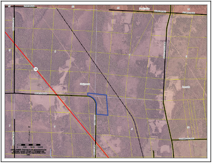
Here’s the verdict based on the findings of fact. “The circuit court properly focused its analysis on what constitutes the best evidence available to establish the boundary line. The best evidence of the boundary line (is) the long occupation of the properties by the parties (and) their neighbors, and their predecessors in title…The record supports the circuit court’s determination that (Henn Road) has been relied upon by the government and private owners alike as the (section line).” Sounds pretty good, right? Well, we’re not through digging yet. If we follow the Supreme Court’s opinion, the legal descriptions should leave the courtroom the way that they came in and the chains of title should be smooth. I don’t see that in Ashland County’s parcel layer. Additionally, I suspect something lead our 2005 surveyor out to the swamp. Perhaps a mechanical retracement of Parker’s 1912 survey or a faithful replication of G.L.O. restoration instructions but we simply don’t know. Something was duplicated there and the Parker monument was found a century later. There’s still something missing that has delaminated Henn Road from the section line and created irregular parcels in Butternut.
Sidebar:
Stop, Drop, and Roll
Okay Mister Boerst, if we buy the unambiguous argument, then what evidence do we use to locate this deed on the ground? Because we ain’t leavin’ the courtroom until this thing is settled. It’s too late to double bubble this by the book. We know that won’t absolutely put us back at the original spot and we may not be working under the authority of all of the owners impacted by the double trouble. The finding of facts indicate that the parties couldn’t muster up enough evidence to prove the swamp corner was in the original spot. In fact the court found no evidence supporting either the road or the swamp monument to be original. So the court has excused the G.L.O. and their whole exercise as original subdivider from the classroom. Where does that put us?
Well, how about at this month’s Stop, Drop, and Roll, which is brought to you by Brown, Robillard, and Wilson (BRW) in Boundary Control and Legal Principles, 3rd. Ed. Section 5.16 “Aids to Interpret the Intent of a Deed.” These well founded concepts are offered by BRW to help the professional make some sense of a deed and they are a good litmus test in general. I’m gonna run BRW’s list against Boerst and see what festers up. You do the same and see if we end up somewhere near each other.
- When the reason for the principle ceases, so should the principle itself. Adverse possession was bandied around the appellate courtroom as the big brother of acquiescence and leading to a misfit of statute by the appellate court. Adverse possession was clearly not Boerst’s original argument, nor could it stand because Boerst did not occupy the disputed turf. Kudos to the circuit and supreme courts for ditching a “principle without a reason”. I’m going to rate this one four stars for relevance.
- Where the reason is the same, the principles should be the same. This one is a no brainer. The circuit court said “…if you’re going to treat the line as being acquiesced to, you have to treat the corner as being acquiesced to. And, therefore, the only way to do that is to treat it as obliterated”. This might be the boundary quote of the 21st century and gets nothing less than five stars.
- One who grants a thing is presumed to grant also whatever is essential to use it. The road come to mind with the possibility of severing access and reconfiguring road frontage if the Section line was moved elsewhere. This was not a focal point in the case and only nets two stars.
- Between rights otherwise equal, the earliest is preferred. Our descriptions are “simultaneous” so the chains of title are equal in right. However, there was a sequence of ancillary events dating back to 1886 that were weighed and postmarked. The Supreme Court noted that Henn Road was the landmark that was laid out closest in time to the original government survey. The 1886 Town minutes, the 1909 and 1917 court cases all offered a time stamp on reliance of Henn Road as the line. The events of evidence after plat and patent are sequential and this one gets a solid five star rating.
- Particular expressions qualify those that are general. Although BRW targets a document with these aids, the actual case is the compilation of documents and behavior. Our Boerst documents are fine in a vacuum but down in the swamp we need other stuff to make them work. Particular expressions, or in our case the actions of the property owners, have qualified the general mechanics of the PLSS. I’m giving this underappreciated observation a solid five stars.
- An interpretation that gives effect is preferred to one that makes void. From 1886 until 2005 the property owners and the earlier courts effectively made everything work peacefully. A survey and interpretation that perhaps may have been mechanically sound certainly offered abrasion with the status quo. I’m stretching on this a bit but the historically accepted interpretation of the line gave effect with respect to Henn Road. The notion that the section line is elsewhere voids the peaceful existence of the community. Although I am evaluating actions rather than deed text I still can work this concept up to a minimum of three stars.
The S.D.R. of the month also has an honorable mention. “In the survey/fence cases, a circuit court first determines whether the boundary line can be determined from the deed and original monuments or markers. If the boundary line cannot be so determined, the circuit court looks to the best evidence of the boundary line”. The first obligation in a retracement survey is to compare the deed with any remaining original monumentation. The second resort is to identify the best available evidence of the boundary line. Unlike the pamphlet of congressional hijinks surrounding the disposition of federal land, I don’t see a third or last resort offered up by this court. I caution the retracement surveyor to stop, drop, and roll at this point.