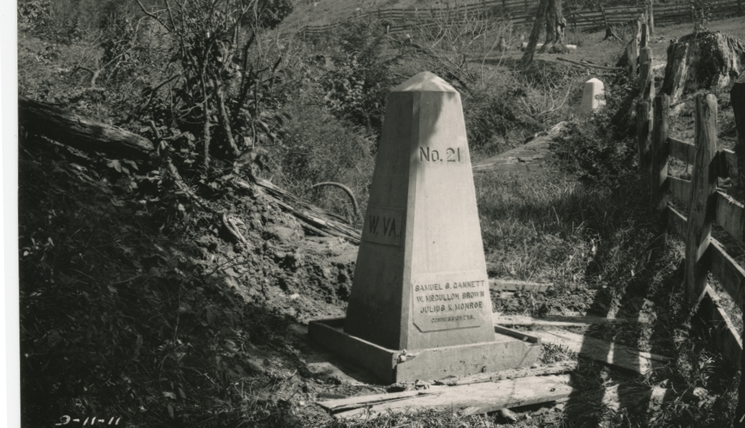
The North–South State Boundary Marker for West Virginia and Maryland. Courtesy West Virginia and Regional History Center— WVU Libraries.
According to 1777 Maryland Law, in regards to the Revolutionary War, “Every effective recruit is to receive, besides the continental allowances, a bounty of forty dollars, a pair of shoes, a pair of stockings, and at the expiration of his term, provided he shall not desert from the army, 50 acres of land, to be procured and laid off as aforesaid, to him or his representative”. This land was surveyed by Colonel Frances Deakins in 1787 with an old magnetic compass. Little did he know, though, that his Westerly line would be retraced, to the highest level of detail, in 1910 by a group of three surveyors including Samuel Stinson Gannett according to a decree by the United States Supreme Court.
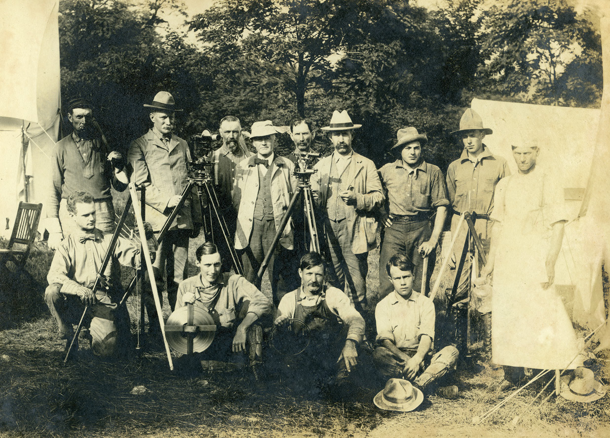
Deakins Line Surveying Team, Preston County, W. Va. Samuel Stinson Gannett is in the back row, second from the left. Courtesy West Virginia and Regional History Center – WVU Libraries.
Currently in present day Allegany and Garrett Counties, Maryland, Deakins, even in 1787, was not the first surveyor in the area. This title goes to the son of former President Thomas Jefferson. Peter Jefferson, along with Thomas Lewis set the Fairfax Stone on October 23, 1746 ultimately marking the Northwesterly corner of the Fairfax Estate on the North Branch of the Potomac River. Similar to all boundary disputes there was of course a North and South Branch of the Potomac, which led to another survey in 1754 by Colonel Thomas Cresap to survey and map out the various branches. The issue did not get resolved as the Revolutionary War broke out, but after the war, the land as surveyed by Deakins was given to the soldiers and officers. All together Deakins laid out 4165 lots of 50 acres each. Most important though was Deakins West line, known as the Deakins Line – and the assumed division between Maryland and Virginia, soon to become West Virginia in 1863.
 The citizens in the vicinity of the Deakins Line were confused to their statehood and their taxation so in 1852 Maryland and Virginia agreed to have a line staked due north from the Fairfax Stone to the Mason-Dixon Line. This was done by Lieutenant Nathaniel Michler of the U.S. Topographical Engineers. Michler was an 1848 West Point graduate and from 1851-1857 worked on the Mexican Boundary Survey. He was then assigned to survey work for the Panama Canal but came back early due to assignment of this survey. Michler did some recon work and found the Fairfax Stone on September 19, 1858, but did not commence actual fieldwork until June 17, 1859.
Michler’s crew consisted of John de la Camp as principal surveyor and up to 19 other members to run survey equipment, clear line and cook. It was then that they ran a line True North by nighttime astronomical observations and distant mountain top gun powder flashes, creating the Fairfax Meridian. It was also then that he found the variations of the Deakins Line. Michler wrote in his report “The Meridian as traced by me last summer, differs from all previous lines run, some varying too far to the east, others too far to the west”. When Michler intersected the Mason-Dixon Line he was about ¾ of a mile feet west of the Deakins Line. Michler further stated “…and from measurements made to it, I found that it was not very correctly run. The surveyor’s compass was used for the purpose, and some incorrect variation of the needle allowed.”
In the end Michler fully understood the ramifications if his line was accepted. He wrote “…and if the meridian line is adopted as the boundary it will cause great litigation, as the patents of most of the lands call for the boundary as their limits.” Michler set twenty monuments in all, seven being stones and the other four inch diameter wood stakes ten to twelve feet tall. Unfortunately the results of this survey sat on a shelf as this time the Civil War broke out and by the time the war was over West Virginia now shared the common boundary with Maryland.
 Historically the bounds of Maryland go back to 1632 with a charter granted from King Charles I to Cecil Calvert, more commonly known as the 2nd Baron Baltimore or the son of Lord Baltimore. The limits were “…unto the true meridian of the first Fountain of the River Pattowmack, thence verging toward the South, unto the further Bank of the said River…”. Maryland officially became the 7th state on April 28, 1788. Virginia used to border Maryland on the West, but during the Civil War, on June 20, 1863, West Virginia became the 35th state. As stated there were multiple branches of the Potomac River, leading to the survey by William McCulloh Brown and Louis Agricola Bauer, known as the Brown-Bauer Line.
Maryland filed suit against West Virginia on October 12, 1891 and ordered the new survey done. This time though, they wanted the true headwaters of the Potomac River monumented being approximately 1.25 miles northwest of the Fairfax Stone. Brown and Bauer set a new Stone, the Potomac Stone, and ran a meridian North to the Mason-Dixon Line. This line, called the Potomac Meridian, indeed converged on the Fairfax Meridian as they checked Michler’s work. According to the report by Brown and Bauer the perpendicular distance between the two Meridians was 5981.10 feet at the Potomac Stone and 5940.30 feet on the Mason-Dixon Line. Also according to the report the Potomac Meridian was 34.67 miles while the Fairfax Meridian was 36.35 miles.
Map showing the boundary line between Maryland and West Virginia from the Potomac River to the Pennsylvania State Line as surveyed and marked under the decree of the Supreme Court of the United States.
This survey was highly accurate. Doctor Bauer was the Chief of the Division of Terrestrial Magnetism at the United States Coast and Geodetic Survey (USGS) and a highly qualified surveyor, astronomer and magnetician. Brown and Bauer chose a principal station on a high mountain and sent some of the crew 8 to 10 miles distant. They would climb a tree and send flashes with a mirror. This position would be located based on astronomical observations and then corrected to true north. Once established the lines would be prolonged to the next mountain top until they reached the Mason-Dixon Line.
The instruments used were owned by the USGS and placed on loan to the Maryland Geological Survey of whom Bauer worked for. The Potomac Meridian was run between August 16th and October 16th, 1897 but in the end was a lot of work for nothing. The Supreme Court made a final decision on to the location of the State Line between Maryland and West Virginia and held neither the Fairfax nor Potomac Meridian. Instead the Supreme Court held the crooked and inaccurate, but occupied and monumented, Deakins Line of 1787.
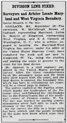
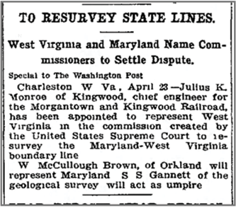
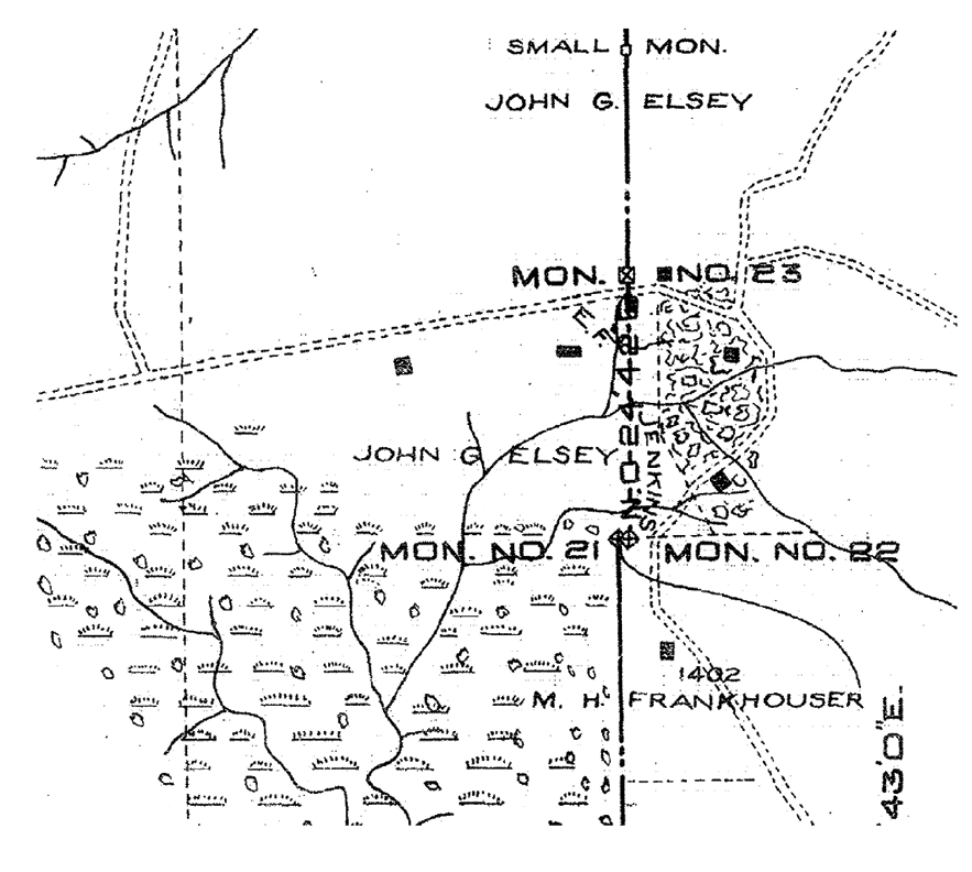
The Supreme Court, according to a decree on May 31, 1910, appointed three commissioners to permanently survey and monument the Deakins Line. Julius Kemble Monroe was chosen to represent the State of West Virginia and William McCulloh Brown was chosen to represent the State of Maryland. The highest Court then chose the Boundary Retracement Specialist Samuel Stinson Gannett from the USGS. Field work commenced on July 12, 1910 and finished in October. The massive crew literally retraced the Deakins line from 1787 starting at, and rebuilding the Fairfax Stone. They used a theodolite on loan from United States and Canada Boundary survey amongst many other tools.
As they marched north, dragging a 500 foot steel chain, they set 65 monuments, both large and small. The small monuments were either copper bolts set in rock or custom concrete monuments one foot square and two feet tall with the initials of the states, sitting on a concrete base two foot square. The larger monuments though were quite a bit more impressive being large molded concrete columns. The bottom was 2 feet square tapering to 10 inches square and four feet high. The corners were beveled and the entire monument then sat on a base of concrete 3.5 feet square and 2.5 feet deep. Each side of the monument was inscribed with reversed bevel faced brass and lead pattern letters. Multiple monuments occupied the site of a tree. As stated in the final report for Monument No. 8 “…a large anciently marked white oak tree…” and “…This tree was cut and blocks taken out by your Commissioners which showed surveyors axe marks in the wood; one 130 years old, one 117 years old, and the last 78 years, thus indisputably establishing this course as following the oldest marked line extant” and “…the tree was cut down and stump blown up with dynamite and replaced by the monument…”.
Upon reading the report it was amazing what this group accomplished under the direction of Gannett. This truly was a retracement survey in the purest form. When complete a report was given by Gannett and Monroe. Brown wrote his own report disputing the work of the others. In the end, even though all three names are inscribed on the monuments, the report with the majority won over the Supreme Court and on May 27th, 1912, the Supreme Court agreed that the survey and monuments set in this survey “…established, declared and decreed to be the true boundary line between the said States of Maryland and West Virginia…”