

Chaffee’s original field books that he carried in the field were preserved and are now located at the Nebraska State Historical Society.
The completion of the first transcontinental railroad on May 10, 1869, greatly changed the way Americans traveled and communicated between distant points. While the railroad transferred people and products, the telegraph alongside transferred information. Nineteen days after the completion of the railroad, Oliver N. Chaffee, a 34-year-old surveyor and astronomer from Detroit, Michigan, entered into a contract with the Iowa and Nebraska Surveyor General, Robert R. Livingston, to survey the 25th and 27th meridians west from Washington D. C. Both the railroad and the telegraph were instrumental in establishing these lines.
The Act of September 28, 1850, (9 Stat. 515), provided that the meridian through the observatory at Washington would be adopted and used as the American meridian for all astronomic purposes. The meridian at Greenwich, England, however, would continue to be used for nautical purposes. The difference between the two meridians was 5 hours, 8 minutes, 12.15 seconds, or 77°03’02.3” of longitude.
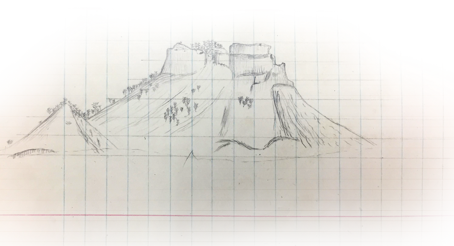
Sketches in the field books were frequently made by Chaffee as he surveyed north on the 27th Meridian between the states of Nebraska and Wyoming.
Chaffee wasted little time in assembling his crew to begin his work and endeavor to complete it by the end of the season. His main assistant was Professor S. W. Robinson whose expertise was making astronomical observations. Arriving at the eastern terminus of the Union Pacific Railroad at Omaha, Chaffee met with Edward Goodfellow who was in charge of newly created astronomical station that had been placed by the U. S. Coast Survey. The Omaha astronomical station was connected to the railroad by telegraph which Chaffee would need to determine the longitudes for his meridians on the western frontier.
Traveling by train to the last station in Nebraska, 463 miles west of Omaha, Chaffee arrived at Bushnell on July 8, 1869. The new town had little more than a water tank, windmill, and a boxcar for the railroad station. A monument was placed near the station where a series of astronomical readings were taken for two days while connected with the telegraph to coordinate with Omaha. Bushnell is about 8 miles east of the 27th Meridian and 16 miles north of the 41st Parallel, a line which Chaffee would also establish to connect the 25th and 27th meridians together.

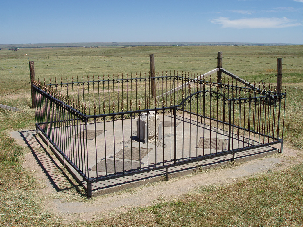
Cattle frequently visit Chaffee’s south end of the 25th Meridian. This monument was later discovered to be over 600’ south of the 40th Parallel where the states of Colorado, Kansas and Nebraska meet. Photo by Jerry Penry.
Traveling 90 miles back east, Chaffee then stopped at Julesburg, Colorado, where he placed a second astronomical station near the railroad station to communicate with Omaha and determine its longitude west from Washington. This location could not have been a more ideal site for the astronomical station. It was only about one mile south of the 41st Parallel, and about 16 miles west of where Chaffee would establish the 25th Meridian. By the time Chaffee arrived at Julesburg, it had already seen its share of excitement. The town was an important Pony Express station in 1860-61 and had been burned by a large band of Lakota Sioux, Cheyenne, and Arapaho Indians on February 2, 1865. (The site of the original Julesburg townsite was approximately 5 miles west of where the town is located today.)
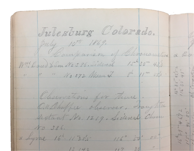 After completing the necessary readings at Julesburg, Chaffee established a meridian and measured 89.65 chains north to place a temporary point at its intersection with the 41st Parallel. By knowing the longitude of his meridian at Julesburg, the exact distance west from the 25th Meridian was determined to be 16 miles 10.47 chains. Chaffee then began measuring east on the 41st Parallel setting square wood posts at the full milepost locations until he reached milepost 9 which is just west of the South Platte River. For unknown reasons, possibly because of continuing hostilities of the Indians near the 25th Meridian, Chaffee returned to his meridian at Julesburg and then began surveying west to place the mile markers on the 41st Parallel until reaching milepost 95.
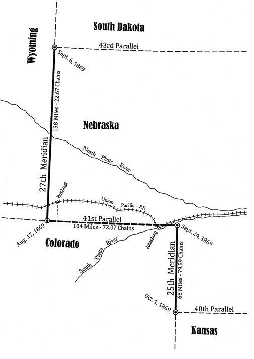
The culmination of three months of surveying resulted in over 312 miles of important lines that form boundaries or corners of five different western states. Map by Jerry Penry.
Knowing he was close to being due south of Bushnell, Chaffee left the 41st Parallel and traveled north to the town. The crew then measured south on the Bushnell Meridian a distance of 16 miles which crossed over the 41st Parallel. Chaffee returned to milepost 95 and continued west on the parallel until he intersected the meridian at 96 miles 22.62 chains. His latitude at this intersection was determined to be 41°00’06.2” which was evidently within the tolerance to not require correcting his line to be 628’ further south. With the known longitude of the Bushnell Meridian, the remaining distance to the 27th Meridian was determined to be 8 miles 49.45 chains. Chaffee extended the 41st Parallel west and placed the intersection of the parallel with the 27th Meridian at a total distance of 104 miles 72.07 chains on August 17, 1869. This monument became the common point to Colorado-Nebraska-Wyoming.
The surveyors then began measuring north on the 27th Meridian across the barren terrain where few white men had previously traveled. The topography along and near

Chaffee’s white limestone monument of 1869 marks the northern end of his 27th Meridian. The quartzite monument alongside was placed in 1893 by a surveyor who established the 43rd Parallel between Nebraska and South Dakota.
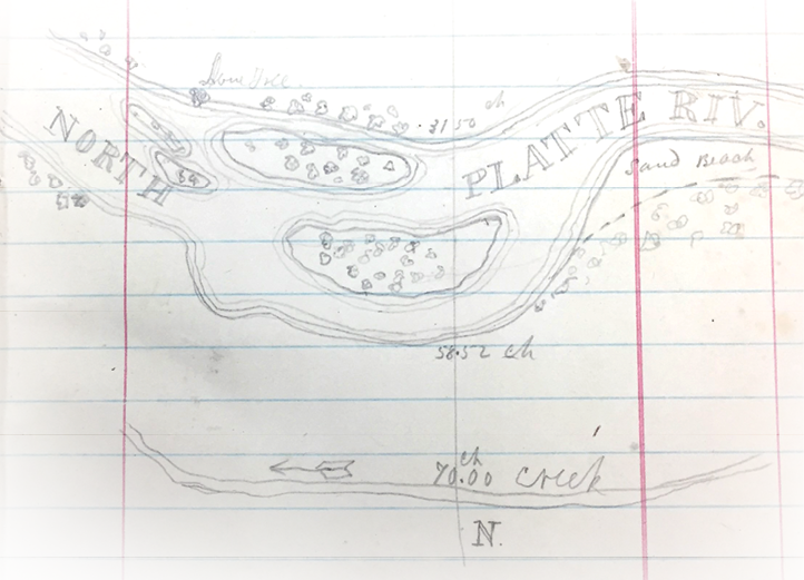
this line presented many spectacular scenes that captivated the crew as they progressed. Chaffee frequently sketched the colorful bluffs in his field book by making grid lines so the images were spatially correct. Between the 68th and 69th miles, the North Platte River was crossed on August 27.
The four monuments needed for the end points of the 25th and 27th meridians were large square limestone monoliths. The sides were smoothed and lettered at an eastern quarry except for the final distances that Chaffee would be required to inscribe. The heavy monuments were shipped by rail to the nearest practical location where the surveyors then transported them by wagon to their points.
As the surveyors neared the northern end of the 27th Meridian, which was the intersection with the 43rd Parallel, a high bluff prevented any possibility of continuing with wagons. At the 128th mile, a final astronomical reading was made in order to determine the latitude and the final distance of 10 miles 22.67 chains needed to complete the line. The crew abandoned the wagons and continued with only the necessary equipment needed to measure. Without a wagon, the heavy terminal monument had to be painstakingly pulled with ropes across the prairie.
The northern end of the 25th Meridian marks the northeast corner of Colorado and the southeast corner of the Nebraska panhandle. Photo by Jerry Penry.
At the beginning of his survey, Chaffee noted that he was utilizing two sets of chainmen. One crew used a 66-foot Gunter’s chain while the other used a 50-foot engineer’s chain to prevent collusion in measuring. As Chaffee neared the northern end of the 27th Meridian, he indicated in his field book that he was also obtaining distances by stadia. The terminal monument was placed on September 6, 1869, at a distance of 138 miles 22.67 chains. This monument became the common point to Nebraska-South Dakota-Wyoming.
Chaffee returned to milepost 9 on to the 41st Parallel and surveyed east to the intersection of the 25th Meridian where he placed a monument on September 24, 1869. This point became the northeast corner of Colorado and the southeast corner of the Nebraska panhandle. From this location, a line was run south on the 25th Meridian setting temporary stakes at each mile. Chaffee had hoped to intersect his meridian with the 40th Parallel that had been established in 1859 as the baseline for the 6th Principal Meridian, but no monuments could be found. The meridian was extended another 2 miles south and the prairie was searched east and west for monuments on the parallel without success. Chaffee then made 101 stellar observations and placed his monument on October 1, 1869, where he determined the 40th Parallel should intersect his 25th Meridian. This monument became the common point to Colorado-Kansas-Nebraska.
Chaffee then surveyed north on the 25th Meridian to adjust the temporary stakes and place permanent monuments at each mile beginning from the southern end so the mileposts would increase from south to north. The intersection of the 25th Meridian with the 41st Parallel was achieved on October 7, 1869, to complete the work. The distance of the 25th Meridian was 68 miles 79.59 chains. Chaffee was paid $7,804.48 for his entire work of 312 miles 14.33 chains on the three lines.
In 1872, the 25th Meridian was extended south from Chaffee’s monument to mark the division between Colorado and Kansas. One year later, monuments were found on the 40th Parallel which prompted the establishment of a new monument at the true intersection with the 25th Meridian. This new monument was 621.7 feet north of Chaffee’s monument.
In 1877, the 27th Meridian was extended north to mark the division between Dakota Territory and Wyoming which established the Black Hills Meridian and its Initial Point 69 miles north of Chaffee’s monument. This meridian extends north to the common point for Montana and Wyoming on the western boundary of South Dakota.
 In 1893, a survey of the 43rd Parallel between Nebraska and South Dakota that was originally performed in 1874 was resurveyed and a large pink quartzite monument was placed next to Chaffee’s limestone 27th Meridian monument at the Nebraska-South Dakota-Wyoming location.
Jasper stone posts replaced the wooden mileposts going north from the 43rd Parallel on the 27th Meridian in 1904 between South Dakota and Wyoming. In 1908, granite posts were likewise placed at the original mileposts of the 27th Meridian between the 41st and 43rd parallels along the Nebraska and Wyoming boundary.
Twelve states have meridional boundaries that are referenced from the Washington Meridian. On August 12, 1912, the act established in 1850 to use the Washington Meridian for meridians and astronomical purposes was repealed and the Greenwich Meridian became the standard. All four monuments placed during the 1869 Chaffee survey have been restored by surveying associations working together from the neighboring states.