 Carlson SurvCE and SurvPC 6.0 Available Now
Maysville, Kentucky, U.S.A. – Carlson Software’s popular and versatile in-the-field land surveying software, Carlson SurvCE 6.0 for data collectors and Carlson SurvPC 6.0 for ruggedized tablets and laptops is now available.
The newly released software features several new features, improvements, and introduces the optional paid Hybrid+ module, allowing users to survey with both GPS and total station at the same time.
“SurvCE 6.0 really focuses on efficiency,” said Sarah Winter, Director of SurvCE Programming Division. “The beauty of Hybrid+ is that it puts all of the surveyors’ tools at their immediate disposal so that they are always ready to get the shot they need when they need it. We know that when our customers are out in the field, they need to collect accurate data as quickly as possible. Time is money.”
New 6.0 features include:
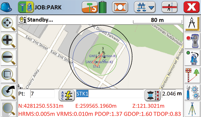
- GIS Inspector—Allows easy viewing of GIS attributes when selecting points in the map, and prompts for attributes when storing points from the map view.
- Surface Inspector—Allows easy comparison of plan versus as-built in elevation difference, making it more simple to store and stake any point in elevation difference.
- Obstructed Point Stakeout—An enhanced stakeout method to stake a point that is obstructed by marking azimuth and distance on two points.
- Automatic Backsite Check—A button to turn to the backsite, measure the position, and report the error
at any time.
For a full list of improvements and technically changes, please see the Release Notes.
The new voice prompting for stakeout and instrument status is exclusive to SurvPC 6.0 and allows users to keep focus on a point.
SurvCE 6.0 provides the option to use Google, Open Street, or Esri map backgrounds and presents enhanced icons in survey screens like the Laser Pointer icon, which will allow users to toggle their laser pointer from any screen. The Instrument Status icon is now available on all screens, indicating a connected and fixed position, and the Search icon now offers all available search options.
Newest instrument drivers added to the list compatible with SurvCE/SurvPC can be found at survce.com/supportedHardware.
SurvCE 6.0 is available in more than two dozen languages: English, Spanish, German, French, French (Canadian), Russian, Portuguese, Czech, Dutch, Chinese, Korean, Greek, Italian, Polish, Hungarian, Swedish, Latvian and more.
Contact your Carlson Software Representative or Certified Dealer for SurvCE and SurvPC sales assistance, as well as complete Hardware and Financing options.
For more information visit carlsonsw.com.
 Geneq Introduces Net20 Pro GNSS CORS-Reference Receiver
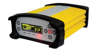
Montreal, QC – Geneq Inc. is pleased to introduce the Net20 Pro, a robust and easy to use system designed for CORS networks. Its efficiency and flexibility will provide you with many years of high quality data for your projects. This product will be useful to any user interested in the proximity and reliability of a reference station while eliminating RTK corrections service charges.
The Net20 Pro uses multi-frequency, 555 channel technologies in a rugged casing that will deliver accurate and effective positioning data even in a harsh environment. This product can be configured for correction data reception in client mode to calculate a fixed RTK position and to monitor the antenna position while continuing to work as a GNSS reference server.
With its NTRIP Caster software, the Net20 Pro provides superior connectivity with an unlimited number of mount points. Users will appreciate the permanent transmission of RTK corrections with a simple local internet connection from your (LAN) working network.
Equipped with an internal memory of 32GB with an additional 32GB external memory, the Net20 Pro provides enough storage space for permanent recording even for a 100Hz high data sampling rate.
The Net20 Pro comes with an ergonomic and easy to manage Web UI that features software upgrade, status and settings management, data downloading, etc. via smart phone, tablet or other internet-enabled electronic devices.
For more information visit the SXblue GPS website at sxbluegps.com.
Construction Adds 19,000 Jobs as Unemployment Plummets in July, Says ABC
Washington, Aug. 3 – The U.S. construction industry added 19,000 net new jobs in July after adding 13,000 net new jobs in June, according to an Associated Builders and Contractors analysis of data supplied by the U.S. Bureau of Labor Statistics. The industry has added 308,000 net new jobs since the first of the year, a robust increase of 4.4 percent.
The construction industry unemployment rate dove to 3.4 percent in July, recording its lowest level in the 18-year history of the series. The national unemployment rate for all industries inched down to 3.9 percent.
Nonresidential construction employment increased by 13,200 net jobs in July. Nonresidential specialty trade contractors added 8,600 net new jobs in July and have collectively added 60,300 net new jobs through the first seven months of the year. To put this in perspective, this is nearly double the amount added through the first seven months of 2017 (+32,200).
“While many observers will focus intensely on the headline employment growth number of 157,000, which was below expectations, today’s employment numbers provide more evidence that demand for workers remains elevated,” said ABC Chief Economist Anirban Basu. “Employment growth estimates for both May and June were revised higher. The official rate of unemployment fell to 3.9 percent. Nominal wage growth remains steady. Both construction and manufacturing continue to add jobs in America.
“The issue, therefore, is not really about demand for human capital, but supply,” said Basu. “There may well have been times during the nation’s history when construction industry unemployment was even lower, but relevant statistics characterizing those periods do not exist. What we know for sure is that contractors will continue to scramble for workers in the context of aggressive spending on structures and other forms of construction.
“The real mystery is how the construction industry has managed to find 308,000 net new workers over the past year given all the narratives regarding a lack of available carpenters, electricians, welders, glass installers, etc.,” said Basu. “One hope is that more workers are gravitating toward construction, which offers increasingly rare opportunities for people to enter the middle class without taking on student debt. The other hope—and there is evidence to suggest this is already occurring—is that companies will invest heavily in the capabilities of these people inducing more of them to stay in the industry even during the next downturn.”
For more information visit abc.org
 Frontier Precision Helps Map Kilauea Lava Flow
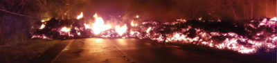
“I had to help out. It was tearing at my soul.” When Kilauea started erupting on the Big Island of Hawaii on May 3, Brennan O’Neill knew he had to do something. As the Hawaiian branch manager of Frontier Precision, he was in a unique position to offer support. Frontier Precision has been at the forefront of geospatial measurement technology for 30 years and was ready to provide free access to technology and expertise to assist in mapping the lava flow.
“I’m a resident of Hawaii,” said Brennan. “For a geologist, it’s even more powerful than that. The lava flow is like a living mass that has a mind of its own, creeping, glowing—an upside-down conveyor belt surging forward and burning everything in its path.”
While the lava can’t be stopped, it can be mapped. Through Frontier Precision, Brennan offered high-tech mapping equipment, his own expertise, and the assistance of Nathan Stephenson, an applied geospatial engineer currently working in the company’s Denver office.
“We used a combination of Trimble R10s and Trimble R8s to gather accurate data points on the ground,” said Nathan. The mapping team flew UAS drones over the flow to gather visual imagery data, matched it to the ground reference points, stitched the photos together and draped it over county maps. The process was repeated as often as needed – daily, and sometimes even hourly—to show the speed and direction of the flow.
Nathan isn’t new to mapping lava flows. As a graduate student at the University of Hawaii – Hilo, he worked on collecting data on the Pahoa eruption in 2014, and he’s seen advances in technology in just a few years. “One thing we have now that we didn’t have in 2014 was a thermal radiometric camera that helps us map more accurately at night and enables us to capture large heat signatures.”
The collected data helps Hawaii Civil Defense and other agencies keep the public informed and safe, and in the long term it also contributes to the store of scientific knowledge about eruptions and lava flow behavior.
The lava flow has formed a channel that now extends out to the ocean. It poses no immediate threat to structures or people aside from gas emissions but could change at any time. Nathan has returned to his home in Denver, but if the situation changes, he would come back to Hawaii. “It was a great experience and I was glad to offer my support. If they need me again, I’ll be there.”
Frontier Precision would be glad to offer assistance as well if needed in the future, whether that be with equipment or with personnel. “Scientific measurement is what we do, and when we can help out on a project like this, it’s the right thing to do and we have the equipment and expertise to get the job done.”
Leica Geosystems, GeoPal Partner to Add High Accuracy to Mobile Operations
Heerbrugg, Switzerland, 26 July 2018 – Leica Geosystems, part of Hexagon, industry leader in measurement technology, today announced its new partnership with GeoPal to support high accuracy asset data capture for utility professionals within the GeoPal mobile workforce management solution.
Leica Geosystems and GeoPal have partnered to support high accuracy asset data capture within the GeoPal mobile workforce management solution.
With increased regulatory pressure on utility organisations to provide more accurate location data and asset records, the Leica Zeno GG04 Plus smart antenna is now seamlessly supported by GeoPal to provide high accuracy positions within GeoPal’s Android and iOS mobile applications.
Alan Grady, contracts manager COFFEY GROUP commented; “We utilise the Leica GG04 plus as part of the GeoPal application for our utility construction workflows. The Leica GG04 plus is simple to use and enables the field team to capture the accurate location of assets as they are installed in real time. This enables us to validate jobs for our clients more quickly and ultimately improves the ongoing efficiency and productivity of Coffey group.”
Moving from paper to digital
The Zeno GG04 Plus brings advanced GNSS technology and industry-leading 555 channel tracking power to Geographic Information System (GIS) asset collection. The smart antenna uses RTK technology and applies Precise Point Positioning (PPP). With an open interface, the technology combines with GeoPal for accurate results and efficient operations.
GeoPal has established a wide base of customers across Europe and North America with its consultative implementation process and easy to-use-platform. GeoPal has engineered the core software infrastructure companies need to go from using paper-based forms to complete digital transformation in the field within just a number of weeks.
GeoPal Director and Co-Founder Paul Coyle commented; “The Leica Geosystems smart antenna is easy to use, and we recognised its value as an ideal tool for non-surveying field operatives using GeoPal, who simply need to capture asset locations as part of their job. The GG04 Plus is simple, reliable and provides accurate location data in the demanding work environments GeoPal’s clients work in.”
Leica Geosystems Regional GIS Segment Manager Mike Cooper commented; “We immediately saw the benefits of the GeoPal workflow for organisations looking to improve the quality of their asset records using their own field resources. This is a more efficient way of working; it improves productivity while delivering key safety and financial benefits. It also ensures contractors can quickly validate jobs within the GeoPal application and ensure their clients have access to that information in real time.”
Woolpert Receives 2017 Google Cloud Partner Award for Customer Success in Google Maps
Dayton, Ohio July 23, 2018 – Woolpert has received the 2017 Google Cloud Global Partner Award for Customer Success in Google Maps. This year’s award was presented today in San Francisco at the Google Cloud Next Partner Summit, an event that showcases Google Cloud partners spanning G Suite, GCP, Maps, Devices and Education.
Woolpert was honored for its demonstrated sales, marketing, technical and support excellence to help customers of all sizes take advantage of the Google Cloud product suite to transform and elevate their businesses.
Jon Downey, Woolpert Vice President and Market Director for Google Cloud Platform, said Woolpert was thrilled to receive this award.
“It’s inspiring to see how we were able to start with our firm’s extensive mapping roots and grow a partnership with a nontraditional mapping company to the degree that we have in four years,” Downey said. “Coming from the public sector and expanding our geospatial mapping expertise into the private sector is a real accomplishment,
and I am proud of my team for all they’ve done to achieve this incredible honor.”
Downey added that this strong partnership will be even more important moving forward, as Woolpert incorporates Google Cloud solutions into more of its services.
“There’s literally no end to what we can do with this technology,” he said.
“Our partners are fundamental to providing a great product to customers, particularly as demand for Google Cloud innovations grows,” said Nina Harding, Global Channel Chief, Partner Strategy and Program, Google Cloud. “We are proud to provide this recognition to Woolpert, who has consistently demonstrated customer success across Google Maps. We’re delighted to continue building together with Woolpert on behalf of customers.”

The RIEGL team receiving the 3D Impact award from Esri. From left to right: Lawrie Jordan (Director of Imagery and Remote Sensing with Esri), James Van Rens (Senior Vice President with RIEGL USA), Christian Sevcik (Manager-Strategic Software Alliances with RIEGL), Kurt Schwoppe (Business Development Manager for Imagery with Esri)
RIEGL Wins 2018 Esri 3D Impact Award
RIEGL is pleased to be the recipient of the 2018 Esri 3D Impact Award last week during the annual Esri User Conference!
The award was presented to the company during the Esri Imagery Summit in San Diego, California on Sunday, July 8, 2018 in recognition of a joint initiative that RIEGL and Esri have been working on: the LMAP initiative.
“RIEGL understands what’s required to make 3D GIS come alive. Their sensors are revolutionizing the notion of a 3D image, and as a trusted Esri Partner, we are working together to ensure our common customers are able to create the map of the future.” stated Lawrie Jordan, Director of Imagery with Esri.
The LMAP, or LiDAR Management Analytical Processing, initiative was designed to leverage Esri’s ArcGIS Platform to store, manage, acquire, analyze and visualize RIEGL LiDAR data. By leveraging Esri’s most advanced 3D technologies for desktop and web environments, new opportunities exist enabling better utilization of LiDAR collections in collaboration with an organization‘s existing geospatial data.
“RIEGL’s offerings meet the demanding needs of 3D GIS. In addition to incredible resolution, they also are focusing their work to miniaturize their LiDAR collection systems to support terrestrial and drone-based platforms” said Kurt Schwoppe, Business Development Manager for Remote Sensing with Esri. “The new RIEGL miniVUX-1UAV LiDAR sensor integrated with the DJI M600 opens an entirely new market for 3D GIS users who are interested in the precision mapping of micro-geographies”, he added.
Esri’s 3D Impact Award is a special award that provides recognition to an individual or organization that has made outstanding contributions within the field of 3D GIS through remote sensing. Recipients are selected based on their efforts to discover and implement new methods or technologies for the collection or creation of content capable of powering 3D GIS.
“We are honored and proud to be the recipient of this prestigious Esri 3D Impact Award, which demonstrates our continuing commitment to deliver a customer-oriented workflow of RIEGL LiDAR data into Esri’s market leading GIS environment. We have had a long-standing relationship with Esri and look forward to growing our partnership to the next level!” said Johannes Riegl Jr., President of RIEGL USA.