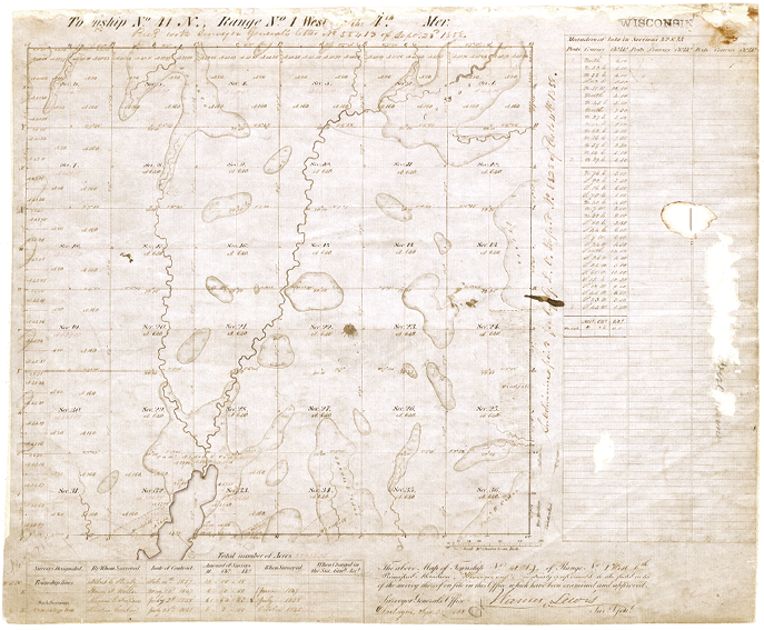
Butternut was all tidy and square in the 1850’s according to the G.L.O. boys.
Last month we waltzed through the evidence and touched on the findings of fact established by the circuit court. Let’s review the arguments and refresh those findings:
“the Boersts sued, seeking a declaration they owned the land between the new section line and Henn Road, land the parties previously believed belonged to the Oppermans. The Oppermans responded that the 1912 survey was inaccurate and that Henn Road actually does lie on the section line. They also argued that even if Henn Road was not on the true section line, all relevant property owners nevertheless treated the road as a boundary line for several decades. For support, they pointed to a 1917 lawsuit concerning Henn Road, in which the parties there stipulated: “the common corner of sections 4, 5, 8 and 9 in township 41 north, range 1 west, Ashland County, Wisconsin, is at the intersection, or meeting point, of the centerline of the highway between sections 8 and 9 as said highway has been used for more than twenty years….” They therefore argued they were entitled to the disputed land under the doctrine of acquiescence.”

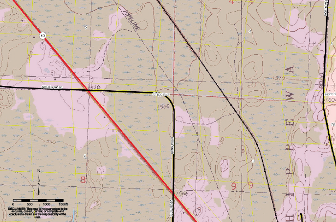
Yellow lines are the parcel fabric. White lines are the PLSS layer square with the G.L.O. plat. Notice how the black road and white record G.L.O. harmonize together.
The resulting findings of fact revealed the following:
- The original section corner monument between Sections 4, 5, 8, and 9 in Township 41 North, Range 1 West, Ashland County, Wisconsin no longer exists.
- No competent evidence is before the court to determine where the original section corner monument was originally placed.
- No clear and convincing evidence exists that the resetting of the corners in the 1912 Parker survey (upon which the 2005 tie sheet is based) was correct.
- Neither party has shown by clear and convincing evidence where the actual boundary line exists.
The circuit court further concluded that the original boundary line between Sections 8 and 9 cannot be determined solely by the descriptions in the deeds.”
Let’s review the decision and appeals.
- “The circuit court found the road was most likely not on the original section lines. However, it concluded that for nearly a century, the property owners adjacent to Henn Road believed it was and acquiesced to the road as the boundary. In a written decision, the court declared Henn Road is the boundary line between the property owners in this case…Northrop (co-plaintiff) requested the court determine whether the corner was lost or obliterated…the court ultimately ruled on the matter concluding that if you’re going to treat the line as being acquiesced to, you have to treat the corner as being acquiesced to. And, therefore, the only way to do that is to treat it as obliterated…”
- The appellate court concluded “the circuit court correctly determined the parties acquiesced to the boundary line, but that it erred when it found the section corner obliterated.”
- The Supreme Court affirms the circuit and appellate court’s rulings that the property line is the centerline of Henn Road but that’s apparently it. “Boerst seek review of that part of the court of appeals decision affirming the circuit court’s determination that the boundary line between their property and the property of Betty and Floyd Opperman is the center line of Henn Road. We affirm this part of the decision of the court of appeals.”
Okay, so there we have it. Apparently the only question that made it all the way through the Supreme Court was “where is their common property line?” The question of “obliterated” was only presented in front of the appellate court.
Federal records superimposed over the local cadastre reveal significant differences. Maybe the 1886 road survey was a wing ding job based on really square and cardinal record info?
I can’t quite get the checkbook to balance here with a notion that the appellate court may have delaminated the PLSS from the property ownership. I follow the circuit court’s logic leading to an obliterated corner although I get there by different means. I might be advancing the spark just a fuzz by assuming that the 1886 survey of Henn Road actually matched the section line and I’ll get to that in a minute. Regardless, if it did match, then it is evidence of the original line and the corner is merely obliterated. However, if it did not match then the corner is lost, right? At least according to the evidence and findings of fact. Okay but the circuit court says something really logical but different. “…if you’re going to treat the line as being acquiesced to, you have to treat the corner as being acquiesced to.” This is profound and maintains the stability of the property on the ground as well as the title description and furthermore the PLSS itself. Stability of boundaries is after all the point of the PLSS and by acquiescing; the owners are performing their legal equivalent of double proportioning under their own will. Now, I agree with the circuit court’s line of thinking but unfortunately I’ve already put all my chips on the 1886 road proceedings and the 1917 court decision both declaring the road as being on the true section line and jumped on that as evidence of the original line.
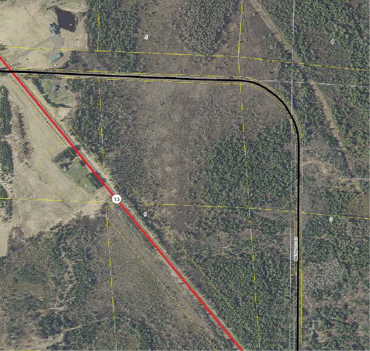
Notice the catawampus cadastral lines (yellow) pointing to the swamp corner and the physical road intersection pointing near the record corner (white) are several hundred feet apart.
There are eight synonymous and interdependent elements here 1.) The actual center line of Henn Road on the ground, 2.) The record centerline of Henn Road, 3.) The west line of section 9 on the ground, 4.) The west line of section 9 of record, 5.) The east line of section 8 on the ground, 6.) The east line of section 8 of record, 7.) Opperman’s deed line dependent on the described aliquot line, 8.) Boerst’s deed line dependent on the described aliquot line. I’m not sure how the appellate court reasoned otherwise or could divorce any from the others? Being that I’m a surveyor and not an appellate judge, generally my next step after a whiff of bewilderment is to grab the shovel and keep digging. So that’s what we’re gonna do.
Okay, let’s Stop, Drop, and Roll here. Our SDR this month is sponsored by the good folks at the Ashland County, Wisconsin GIS Department. Let’s give a shout out to Brittany at Ashland County for her assistance in the matter! I took a gander at Ashland County’s awesome GIS to get a lay of the land and started to see how the circuit court might arrive at our similar “obliterated” conclusion but through a different path, namely acquiescence. Well, for starters, the aerial view shows Henn Road is pretty much cardinal and matches the PLSS Cadastral layer, the GLO plat, and the USGS Quad sheet’s cadastral line work. (see photo). Remember, other than the roadbed itself these items are “record” evidence and most likely are just reverberations of the GLO plat and this probably explains why they match and feel equally cardinal. On the other hand the parcel/aliquot fabric layer resembles drunken dominoes in the galley of the Edmund Fitzgerald. It becomes apparent that something in the ground work may have severely deviated from the original G.L.O. record and maybe Henn Road wasn’t quite where Butternut’s 1886 surveyor thought it was. Okay, that doesn’t really resolve any boundary questions but it shows us things aren’t so certain in this neck of the woods and perhaps why the circuit court was unable to muster competent evidence of the original position of the section corner. Regarding me placing all my chips on double zeros, I quote that old hippy turned hillbilly Kenny Rogers “you gotta know when to hold ‘em, when ta hold em, know when ta fold ‘em, when ta fold um”… looks like Foose is foldin’ on that call.
One last thing about the 1886 road survey. If it was fact that the road was surveyed on the true section line in 1886 then wouldn’t that support Opperman’s obvious first response that the road is competent evidence? There’s an 1886 survey and a 1917 court stipulation supporting that response yet the finding of fact was “No competent evidence is before the court to determine where the original section corner monument was originally placed.” These are big ticket items for a court and to the best of my knowledge extremely strong evidence because they are sworn or certified by presumably competent people, especially the 1917 court. Things are not jiving here and I’m starting to think we’re working off of a 2 legged tripod. Let’s keep pokin’ and stokin’ with the shovel.
Have any of you cheeseheads ever heard of Wis. Stat. § 893.24? Well the appellate court sure did and justly applied it…or did they? The law reads:
“(1) A written instrument or judgment that declares the boundaries of real estate adversely possessed under s. 893.29, 1995 stats., or s. 893.25, 893.26 or 893.27 does not affect any section line or any section subdivision line established by the United States public land survey or any section or section subdivision line based upon it.
(2) Occupation lines that the court declares to be property lines by adverse possession under s. 893.29, 1995 stats., or s. 893.25, 893.26 or 893.27 shall, by order of the court, be described by a retraceable description providing definite and unequivocal identification of the lines or boundaries. The description shall contain data of dimensions sufficient to enable the description to be mapped and retraced and shall describe the land by government lot, recorded private claim, quarter-quarter section, section, township, range and county, and by metes and bounds commencing with a corner marked and established by the United States public land survey or a corner of the private claim.” Quite frankly I wonder how the appellate court even got here. This case is a question of the location of the common line between two deeds describing a common PLSS line where evidence might place it at either along the road or at the 2005/1912 monument. The appellate court somehow arrived at the following: “(the circuit court’s decision) appears to suggest the Boersts’ and the Oppermans’ property boundary and the boundary between sections eight and nine are one in the same. Such a conclusion would be at odds with the court’s conclusion the road is the boundary because the relevant property owners acquiesced to it, not because it lies on the true section line. We therefore reverse that part of the judgement suggesting Henn Road is the section boundary…” I’m simply hung up on the appellate court’s apparent lack of respect toward the legal descriptions in the deeds. There was no finding of fact that upset the expected behavior of the operational section line. Namely it’s the line between 8 and 9 as described by the deeds, patent, and plat. There was no finding that the deeds describing the aliquot lines were bunco either. The evidence of title deeds, town minutes, road survey, both 1900’s court decisions, and state highway survey all showed the section line and property line common with the road. Actually, the findings of fact point in the direction of a lost corner and beg for some restorative support like acquiescence. It seems like the appellate court omitted the fact “No competent evidence is before the court to determine where the original section corner monument was originally placed.” I really think I’m missing something here and need to dig deeper.
I reiterate, the circuit court declared “No competent evidence is before the court to determine where the original section corner monument was originally placed.” and “No clear and convincing evidence exists that the resetting of the corners in the 1912 Parker survey (upon which the 2005 tie sheet is based) was correct.” Having no original monuments, the circuit court resorted to extrinsic evidence to place the legal descriptions on the ground. Best I can tell is that the legal descriptions were not broken but they were dependent on missing monuments and the extrinsic evidence was used to fill that gap. I personally relate this as the owners’ legal equivalent to G.L.O. double bubbling but across private domains. Instead of pure math controlling a “no-damages” solution within the singular title of the public domain, the court relies on the common behavior of the owners as an equitable solution to control the position of the replacement corner. Hmmmm…This is starting to sound like a state court might have to address a beast that lives and breathes in the purgatory between “obliterated” and “lost”, doesn’t it?
So here it is folks, the pig flying around the 800 pound gorilla dancing with the elephant in the room. The Supreme Court stated that “The record supports the circuit court’s determination that the centerline of Henn Road has been relied upon by the government and private owners alike as the boundary line between sections 8 and 9 in Township 41 North, Range 1 West, Ashland County, Wisconsin. The evidence in the record prior to the events leading to this litigation supports a finding of longtime undisturbed possession of property based upon the center line of Henn Road as the boundary line.” Sounds great, right? The circuit court got it and the appellate court blew it. Here’s the twist. I don’t think the “obliterated” question was directly offered to the Supreme Court through appeal so I’m not sure what the weight of that statement is. We need to keep digging!
Okay, this month’s totals are:
- Foose bit the dust on the road being laid out from original monumentation.
- The property line and the road match.
- The section line matched the road in the circuit court.
- The section line did not match the road in appellate court.
- The section line matched the road in the Supreme Court but the appeal only referred to the question of the location of the property line.
- Butternut’s cadaster is worse off now than before the case.
- Thomas Jefferson is ready to pack up and move to Canada.
I feel like I’m open in the end zone but Favre is running a different play. I’m still convinced we don’t have the whole story or maybe I’m just not readin’ this right, but my shovel hand is itchin’ to keep digging. Any of you cheeseheads got anything on this case? Feel free to contact me at rls43185@gmail.com.
 The Barbershop Barrister
Right now the Ashland County GIS clearly depicts confusion, mayhem, disorder that would have old T-Jeff boycotting the last election and leaving the country. How is it that the integrity of these chains of title can be legally upset beyond a point of recognition? The simple answer is that they should not be. This case was clearly a question of “where does the line fall on the ground?” rather than “what are the legal limits of these adjoining land titles?” The deeds were not broken. From my perch, Boersts’ original declaration that they owned the Oppermans’ land between the new section line and Henn Road does not seem to fit an adverse possession argument. Oppermans’ apparently occupied that chunk and it doesn’t seem that Boerst was able to scrape together any satisfactory evidence of adverse possession otherwise. Regardless, if the “new” section line was in fact the true or the accepted section line then Boerst would have rightfully owned that land in the first place and maybe a trespass declaration would have been more appropriate? I don’t really know and will call that nothing more than a strong dose of good old fashioned barracks lawyerin’ on my part.
I’m stuck on how the appellate court could undo the pedigree of a functioning legal description. In this worst case scenario of “lost corners” the strength of the PLSS is the equity afforded to owners by the original simultaneous conveyance. I don’t think in this case that either owner has superior title per deed until occupation is disengaged from the section line by the appellate court. I also don’t see where facts proved disengagement regardless of proving that the original mark was lost or obliterated. There is a set of restoration instructions that suggests exhausting every scrap of evidence and following state law before resorting to double bubbling as an arbitrary redistribution of dirt among unsuspecting owners. Even after the last resort of double trouble is employed, the integrity of the aliquot descriptions is maintained, right? All of the sections still have the same legal description; they just are not as square on the ground as they were on the original plat. The circuit court reviewed the facts and arrived at a place where the title descriptions were unmolested and the evidence revealed the position in which line naturally settled under a century of human interaction. Everything worked!
So the appellate court inherits a bonus question asking if the corner is lost or obliterated. IT IS OBLITERATED! Why and why the yelling Foose? Because the circuit court found more than a scintilla of evidence in the 1886 town minutes and road survey, and the two previous court cases laminating the road, the property and the section line as one. This is the written legacy of the section line and it was backed up by everyone that touched or used it. I get the feeling that back in 1912 Parker might have tried to right a ship that set sail without him by pulling a double whammy out in the swamp. If so, he probably did everything technically correct and pissed everybody off to the point of just respecting the improvements on the ground. After all, it was their property, not his or the G.L.O.’s to reconfigure and that’s my two cent speculation so let’s leave it at that.
But not so fast on the “obliterated” deelio here folks. The findings of fact lean more toward the definition of lost. That’s giving me a little heartburn but I think it gets washed out by the circuit court’s final conclusion supporting the acquiescence line. It’s hard for me to imagine a place where corners are truly lost after a patent is issued but this swampy glacial plain is one of them. So hats off to these badgers for keeping the PLSS afloat regardless of the catawampus appearance on a map. Wisconsin is rich in boundary case law and influential nationally. That’s why I’m concerned when it looks like a series of decisions working in concert with an interpretation of state statute ends up undermining the PLSS. Sure there’s gonna be bumps, bruises, and wear & tear on T-Jeff’s grid that naturally add flavor but this case ends up nullifying the PLSS or at least deeming it irrelevant. If dependent property descriptions are going to be delaminated from the grid then the grid becomes nothing more than a ceremonial old locust shell stuck in the tree bark. Useless, hollow, and dead.
If a corner is lost it can neither be proven nor disproven where it actually existed because nobody really knows at that time. This also means that nobody can prove or disprove that a replacement corner fell in the same spot as the original. It’s simple, we just honestly don’t know and that’s my supplement to the written definition of a lost corner. Best I can tell, the only evidence of a corner in the active federal arena is the monument placed by surveyors or perhaps some authorized activity like a lease or right-of-way. Most everything else is a permitted use or trespass but immune from any adverse claim however don’t bank on that notion until you fully understand the federal hoohaw. However, something different happens outside of the sterilized walls of the federal arena. Human intervention excited by the psychology of human want, familiarity, greed, protection, defense, peacefulness, aggressiveness, industry, productivity, good manners and just plain old bad behavior among every other human condition is captured in title. As sure as some knothead has thrown fast food wrappers and diapers along the road, we can count on mankind to leave some scrap of evidence pointing to an original line.
Knowing how double proration works I’m inclined to say that it is highly unlikely if not impossible that a replacement corner would fall back in the original spot. I also question the use of the technique from “found” non-original corners but that’s another topic. The bottom line is that there is a need for a court to employ some evidentiary method to restore a PLSS corner. Outside of the federal arena there is a realistic condition between the definitions of obliterated and lost. I think this beast is related to “title” or maybe better called “competing titles”? Where human interaction supplements deed descriptions, we might be well served to adopt operational section lines as the true section line when the evidence and facts put all else to rest. There’s a form of acquiescence that is the equivalent of a silent double bubbling in the private domain and I think the circuit court found it in Boerst. It’s not the familiar argument of the doctrine being employed as a remedy to fix uncertain title. Probably just the opposite. It establishes the place that the healthy title line has naturally landed. From a title perspective the PLSS is pretty bulletproof or at least as much as any other simultaneous conveyance is. A court realizing the natural placement of a line by a series of events offered in evidence and supported by fact is about as good as it gets in lieu of original monuments.
The purpose of the PLSS is to provide stability and it did that in Butternut for 119 years. The duct tape and bailing wire that held the 1886 road action and 1917 court decision together matured and bonded itself to the land like roman concrete, at least to the adjoining owners and the folks enjoying the public road which are indeed the consumers, end users, clientele, constituents, and reason for the exercise. I get the feeling that legislation may have inadvertently overburdened the function of common law at the appellate level and created a legal vortex upsetting these chains of title in Butternut. Before I get too crazy here, I must declare that I do not know the local standards of practice nor the way the Wisconsin laws roll out on the ground. I really do think I’m missing some things here, so my hope is to turn up solid answers and get us all some discount knowledge.