 Public education in the United States and the need to determine ways to fund our schools dates back to the founding of the nation. In order to provide aid for public education, Congress passed the Act of May 20, 1785, that set apart Section 16 of every township for that purpose. By early 1796, state and local governments in fourteen of the fifteen states were taxing land, which helped to fund schools, but the lease or sale of Section 16, however, went directly toward funding education. In organizing new states and territories, this policy was understood as a settled principle. When Oregon was established in 1848, Section 36 was added, thus making two sections, or 1,280 acres, in each township set aside for school funding purposes. A common misconception is that schools had to be built upon these sections.
Unless adverse rights existed, the surveyed lines of Sections 16 and 36 in each new state or territory were fixed and the appropriation for the educational aspect was complete. In the event that land was being occupied prior to the survey, or if an entity such as a railroad crossed either sections, acreage in equivalent tracts was selected elsewhere as a replacement. In most states, the  school land was placed in a trust with conditions and obligations by the individual states to fulfill the requirements.
In the State of Nebraska alone, nearly 2.9 million acres were originally granted in the trust for the support of K-12 public schools. To manage these properties, the Board of Educational Lands and Funds was established to serve as trustee. The Board serves as both the land owner and the land manager. While in the capacity of land owner, funds are used for maintenance, conservation, and improvement of the land under its care. Similarly, in the capacity as land manager, leases are maintained for both surface use and subsurface exploration and extraction of natural resources.
With the placement of the Surveyor General’s signature upon the General Land Office plats, the land within Sections 16 and 36 automatically came into the ownership of the State. Homesteaders seeking land knew that these two sections were off limits for ownership, but by having their homestead adjacent to a school section, it often put them in an advantageous position to lease all or parts of the land.

A large portion of Frederick Welch’s Section 43 homestead was placed in the southeast corner of School Section 16 in T24N-R31W, 6PM.
The system seemed infallible, but no one could have predicted the extent of fraud that took place during the western GLO surveys where many townships were either in corrected subdivided or not surveyed at all. Fictitious topography on plats, the absence of monuments on the ground, and unqualified land locators acting in the capacity as surveyors placed many homesteads on school sections. Improvements were then made upon the school sections with the belief that they were on other sections. The differing opinions of county surveyors and land locators as to where the lines should be located resulted in widespread disputes to the extent that the situation seemed unsolvable.
All was not lost. If the settlers within a particular township collectively agreed to petition the federal government for help, a complete resurvey could be made to aid in resolving the conflicts. These petitions, however, were made without consultation or input from authorities at the state level who were best qualified to resolve local disputes.

Nearly half of John Allison’s Section 54 homestead was placed in School Section 16 of T22N-R38W, 6PM.
The resurveys made special consideration for the locus of the improvements that homesteaders had already made such as houses, barns, corrals, and other physical structures that could not be easily relocated. The resurvey also could not move a homesteader into an area that was geographically impossible to live upon such as rugged hilltops or lakes. To solve this situation, the GLO instructed the contract surveyors doing the resurveys to first reestablish the interior corners within the township and then personally meet with each homesteader to create new tracts of 160-acres where the homesteads were currently located and not where they should be located by deed or patent.
This system required complete cooperation among adjacent landowners where common boundary lines were agreed upon. Each new tract within a township had its own metes and bounds description and were numbered beginning with 37 to avoid confusion with the regular numbered sections. Within the special instructions, there was nothing to address what the surveyor should do if an existing homestead fell within Sections 16 or 36. Unbeknownst to the State of Nebraska, the federal government routinely created new tracts for private individuals upon school sections where the State already held title.
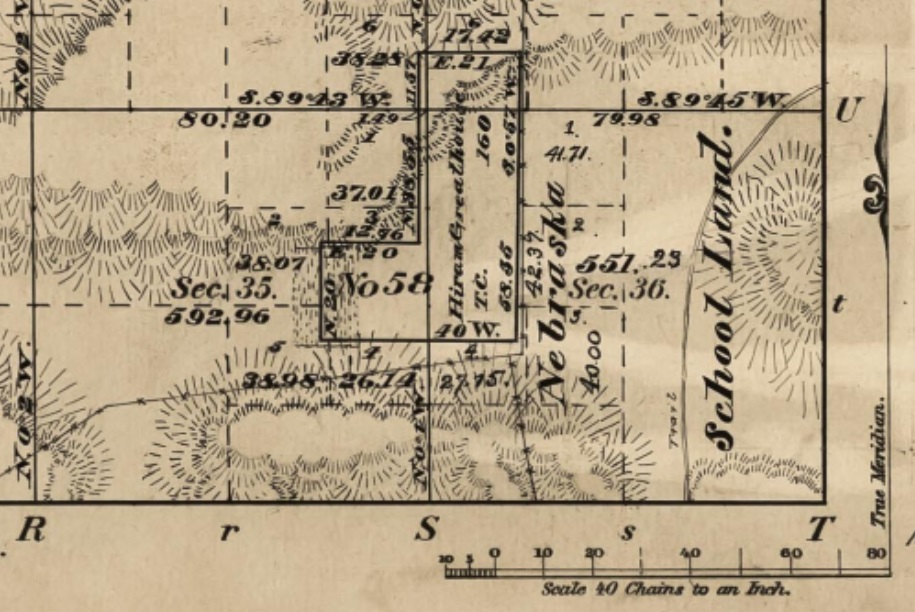
The timber claim of Hiram Greathouse, designated Section 58, was placed mostly in School Section 36, T24N-R37W, 6PM by a Federal Government surveyor. This was done without the knowledge or approval from the State of Nebraska.
Two entire counties in Nebraska, Grant and Hooker, were completely resurveyed in 1895-96 by Willard W. Alt who was awarded the contracts by the GLO. Alt would later resurvey various other townships in the western portion of the state and his work became collectively known as the “Alt Surveys”. The State of Nebraska, however, initially refused to accept them.
The situation with private individuals occupying school sections was not immediately discovered until those holding leases began to complain that they were being assessed a full amount, but homesteads were occupying portions and this acreage was not being subtracted in the lease contracts. A widely-known case involved a cattle rancher, John Bachelor, who was leasing 640 acres of a school section for hay harvesting. As a result of an Alt survey, Silas Waite had 27.62 acres and Woodruff Ball had 107.27 acres of their homesteads placed upon the same section. Bachelor was being charged for the full 640 acres instead of the 505 acres that he was able to use. The State acted as plaintiff in what became State v. Ball that was initially tried in the Nebraska Supreme Court in 1911 in favor of the State. Ball had been paying taxes on his tract for 11 years, so laches was used as an equitable defense. This case was retried in 1913 in favor of Ball when the issue of whether a falsified corner nearly a half mile off could be disproven as an original GLO monument was also brought into the case.
After decades of trying to deal with two separate surveys, the resurveys by Alt were adopted by the Nebraska legislature for Grant and Hooker counties in 1915 and other areas were adopted in 1929. The Nebraska state surveyor, however, objected stating that the matter was for the courts to decide and not the legislature. The issue came up again in 1949 when the assistant attorney general gave an opinion to the Board of Educational Lands and Funds that the original government surveys were controlling insofar as title to state school lands was concerned. He further stated that the legislature had erred when authorized changes were made in abstracts that reduced the acreage of school sections where homestead conflicts occurred in later resurveys.
For many years, landowners sought the school land leases because they did not have to pay property taxes and their leases were automatically renewed for 25 years. In 1947, the 25-year duration of a lease, however, was lowered to 12 years. A 1949 court decision decided that leases could not automatically be renewed, but rather needed to go to auction for the highest bidder per acre. In 2001, certain leased school land became taxable as if the leaseholder actually owned it. Over one-half of the state trust land has now been sold in Nebraska, but it still retains 1.256 million acres or the equivalent of 1,962 sections from which a gross revenue of $47,505,311.79 was obtained during the fiscal year 2016-2017.