![]() Leica iCON Construction Total Stations Provide Efficient Layout Solution
Leica iCON Construction Total Stations Provide Efficient Layout Solution
Leica Geosystems, part of Hexagon, industry leader of measurement technology, announced today the new Leica iCON construction total stations, Leica iCR70 and Leica iCR80, the most productive one-person layout solution for building construction. The intuitive new iCON construction total stations increase efficiency on any building construction site by automatically identifying the prism and automatically relocking to it, should the line of sight be lost, delivering the most reliable, simple and automated setup routine for construction layout. The iCON layout solution, consisting of the new iCON construction total stations, the Leica iCON CC80 field tablet and an enhanced version of the iCON build field software, is aligned with modern Building Information Modelling (BIM) processes and provides a simplified and seamless dataflow of fully rendered 3D design models, between the office and field and vice versa. leica-geosystems.com/leica-icr70 · leica-geosystems.com/leica-icr80 leica-geosystems.com/icon-build
![]() Topcon Releases New Edition of MAGNET Software Suite for Optimized Workflow
Topcon Releases New Edition of MAGNET Software Suite for Optimized Workflow
Topcon Positioning Group announces the release of the latest edition of its suite of software solutions–MAGNET® 5. Packed with new features, the release includes upgrades to the MAGNET Field, Office and Enterprise applications designed for advanced performance, thirdparty integration, and construction planning and oversight capability. The updates include new functionality that spans the suite. “With MAGNET 5 we have focused on key improvements that put positioning professionals and contractors in more control of the work that they perform,” said David Ahl, director of software product management. “MAGNET Field operators can now avoid losing time switching between screens thanks to new flexible display options. Users can simply select and stake surfaces, and drive survey sessions directly from the map. The screen also includes a configurable favorites toolbar, and additional customizable data labels. Additionally, operators can view GNSS status when the controller is connected to a total station in Hybrid mode, and show offsets as a visual reference when staking roads and lines.” Improvements to MAGNET Field also contain new vertical construction capabilities including reflectorless layout within a building. topconpositioning.com/MAGNET5
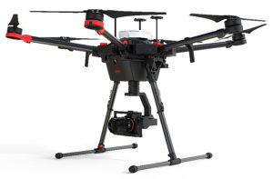 Leica Geosystems Combines New UAV Technology with DJI Aerial Platform
Leica Geosystems, part of Hexagon, industry leader in measurement technology, announced today the new Leica Aibot, the latest Unmanned Aerial Vehicle (UAV) system based on DJI’s aerial platform, the M600 Pro, to rapidly and autonomously acquire mobile 3D mapping data. The new Leica Geosystems UAV technology allows users to get a complete data set in less time with a user-friendly and innovative interface, opening new business opportunities while spending less time, costs and effort than with traditional methods. Leica Geosystems software suite supports the new UAV workflows. Using Leica Infinity for point cloud, digital surface model and orthophoto generation enables surveyors to easily process and visualise aerial data to maximise productivity and speed-up data delivery. Supporting users to share data to Cylcone and Cloudworx, the integration of the UAV point cloud with terrestrial scan data enables users to make the most informed decisions. This complete set of data results in higher project efficiency. leica-geosystems.com/products/uav-systems
 Trimble Catalyst Now Supports GLONASS
Trimble (NASDAQ: TRMB) announced today that its Trimble® CatalystTM software-defined Global Navigation Satellite System (GNSS) receiver for Android phones and tablets has been updated to support GLONASS. The update demonstrates the advantages of software GNSS for delivering new functionality faster and easier.
Access to the GLONASS constellation increases the number of GNSS satellites visible when working in the field. As a result, it improves the ability to maintain lock on enough satellites to keep working when sky visibility is limited or obstructed, such as under tree canopy and in urban high-rise environments. Users also spend less time waiting for the receiver to achieve an accurate position; convergence time is faster and more reliable. geospatial.trimble.com
 Topcon Announces New Data Controller
Topcon Positioning Group introduces the new T-18 handheld controller designed to drive geopositioning, construction, mapping and vertical construction applications. The controller includes a 3.7-inch sunlight-readable display with a 1GHz processor, 1GB of internal storage, and up to 10 hours of battery life. “For MAGNET® Field data collection, the T-18 controller offers a durable ergonomic solution with faster processing, a larger screen, better connectivity and longer battery life than previously available comparable systems,” said Ray Kerwin, director of global surveying products. The T-18 features a 3.5G cellular modem for connectivity with Topcon MAGNET solutions for sending and receiving data to the cloud company account. “The cellular option makes it easy to communicate with field crews when projects need to be changed or if important data is required back in the office. Additionally, the modem can be used for RTK (real-time kinematic) correction services,” said Kerwin. Additional key features include standard Bluetooth® and Wi-Fi connectivity, as well as an IP65 rating for dust and water protection in demanding job site conditions. topconpositioning.com