 If you are fishing on the St. Louis River near Lake Superior you may use a fishing license from either Wisconsin or Minnesota. However, according to the 2017 Minnesota Fishing Regulations, “You must obey the regulations of the state in which you are fishing. More permissive regulations are limited to that state’s waters”. That being the case I want Samuel Stinson Gannett in my fishing boat as this State Line Boundary is about as confusing and crooked as we will ever see. We will once again see how he determined a State Line this time between Wisconsin and Minnesota and this time on a river. We will see how he continues to fit the mold, even in this unique example, of the State Line Boundary Retracement Specialist. Controversy lingered for decades as to who owned what (and where) in the St. Louis River between Wisconsin and Minnesota.
The General Land Office Surveyors closed in on both sides not helping the situation at all. Tempers flared as companies and citizens were being taxed by both States and eventually a lawsuit was filed. In the lawsuit against Wisconsin; Minnesota argued four points on October 16 & 17, 1919. The two main points were to have the river permanently located as it was in 1846 and the second was to use the Thalweg doctrine for determining the position of the State Line. According to Definitions of Surveying and Associated Terms, the Thalweg doctrine is “An international law concept which defines water boundaries between states by the middle of the deepest or most navigable channel, as distinguished from the geographic center of the line midway between the banks”. This leads us to the definitions of the boundaries of the two states. Wisconsin came first, with an Enabling Act dated August 6, 1846. The common boundary in question along the St. Louis River was “…thence through the center of Lake Superior to the mouth of the St. Louis River; thence up the main channel of said river to the first rapids in the same, above the Indian village, according to Nicollet’s Map…”. Statehood was granted on May 29, 1848 making it the 30th State.
Minnesota on the other hand didn’t get their Enabling Act put together until February 26, 1857. Their boundary stated “…to the main channel of the Mississippi river; thence up the main channel of said river, and following the boundary line of the state of Wisconsin; until the same intersects the St. Louis River; thence down said river to and through Lake Superior…”. Statehood was granted on May 11, 1858 making it the 32nd State. The Supreme Court listened to the arguments for two days and upon further research and studies didn’t actually make a decision until March 8, 1920. This decision was based on testimony from both sides, a study of each States Enabling Acts, Old Maps and prior lawsuits involving the Thalweg doctrine. This included cases between Iowa-Illinois, Louisiana-Mississippi, Washington-Oregon and Arkansas-Tennessee. According to the Honorable James C. McReynolds “The doctrine of Thalweg, a modification of a more ancient principle, which required equal division of territory, was adopted in order to preserve to each state equality of right in the beneficial use of the stream as a means of communication. Accordingly, the middle of the principal channel of navigation is commonly accepted as the boundary.
 Equality in the beneficial use often would be defeated, rather than promoted, by fixing the boundary on a given line merely because it connects points of greatest depth. Deepest water and the principal navigable channel are not necessarily the same”. He continued in the end saying “That the boundary line between the two states must be ascertained upon a consideration of the situation existing in 1846 and accurately disclosed by the Meade Chart”.
The Meade Chart was one of three maps studied between October and March. The first map studied was of course the Nicollet Map from 1843. It was determined that the degree of accuracy of this small scale map, equating to 20 miles to an inch, basically rendered it unusable. The second map was one by the British Navy under Lieutenant Henry Wolsey Bayfield between in 1823. Joining the Navy at ten years old he was obviously a well-respected surveyor but once again the scale of his map was one in which again rendered it unusable. The weight then fell on the map prepared in 1861 by Captain George Gordon Meade of The Bureau of Topographical Engineers of the War Department. Luckily this map was one of immaculate detail and proved to be the best source of determining what the St. Louis River looked like in 1846.
The next step in this process was to appoint Commissioners to ascertain said line. This consisted of three highly experienced men: William B. Patton of Duluth, Minnesota, John G.D. Mack of Madison, Wisconsin, and Chairman Samuel S. Gannett of Washington, D.C. Patton was the Manager of the Duluth Engineering Company and Mack was the State Chief Engineer of Wisconsin. Gannett, as we know, was the Chief Geographer of the United States Geological Survey. The first meeting of these three men was on October 29, 1920 in Duluth, Minnesota.
Upon review of a copy of the Meade Chart the decision was made to travel to Detroit, Michigan to make a tracing of the original map. At this time Gannett also requested copies of the notes and triangulation tables. This was absolutely critical to be able to tie into and retrace what Meade did in 1861. He also got copies of triangulation notes that were taken off now obliterated Meade Triangulation Stations. With all this information in hand they laid out all the maps and prepared for the actual field work. The State Line was literally traced from the Meade Map, based on the Thalweg Doctrine, and given a coordinate value.
![]() The field work consisted of three major components. The first component was to tie into as many triangulation stations as possible and set new control where necessary. In 1861 Meade laid off a 19,000 baseline on the spit of land along Lake Superior. These were highly used and highly regarded monuments. They were so often used the Corps of Engineers, as late as 1980, maintained Bilby Towers over them surround by Chain Link Fence. The monuments themselves are noteworthy. The southerly base point is a 12 inch square by 4 feet 10 inch long piece of granite with a drill hole in the top. Below that is an impressive 12 inch square by 3 foot long block of red sandstone with a triangular shaped plug with an “x” five feet below the surface. Historically this was also referenced by three additional red sandstone blocks. Today the granite surface monument still exists, but the Bilby Tower and reference stones have been removed. Later on when the U.S. Coast and Geodetic Survey came along they accepted the work of Meade and placed designations on each base line monument. This triangulation field work was started first while the remainder of the field operations had to wait until the St. Louis River was solidly frozen all together being early January to March 19, 1921. When it was frozen they laid out the calculated angle points and literally drug a three hundred foot calibrated steel tape on the ice completing the second component.
The field work consisted of three major components. The first component was to tie into as many triangulation stations as possible and set new control where necessary. In 1861 Meade laid off a 19,000 baseline on the spit of land along Lake Superior. These were highly used and highly regarded monuments. They were so often used the Corps of Engineers, as late as 1980, maintained Bilby Towers over them surround by Chain Link Fence. The monuments themselves are noteworthy. The southerly base point is a 12 inch square by 4 feet 10 inch long piece of granite with a drill hole in the top. Below that is an impressive 12 inch square by 3 foot long block of red sandstone with a triangular shaped plug with an “x” five feet below the surface. Historically this was also referenced by three additional red sandstone blocks. Today the granite surface monument still exists, but the Bilby Tower and reference stones have been removed. Later on when the U.S. Coast and Geodetic Survey came along they accepted the work of Meade and placed designations on each base line monument. This triangulation field work was started first while the remainder of the field operations had to wait until the St. Louis River was solidly frozen all together being early January to March 19, 1921. When it was frozen they laid out the calculated angle points and literally drug a three hundred foot calibrated steel tape on the ice completing the second component.
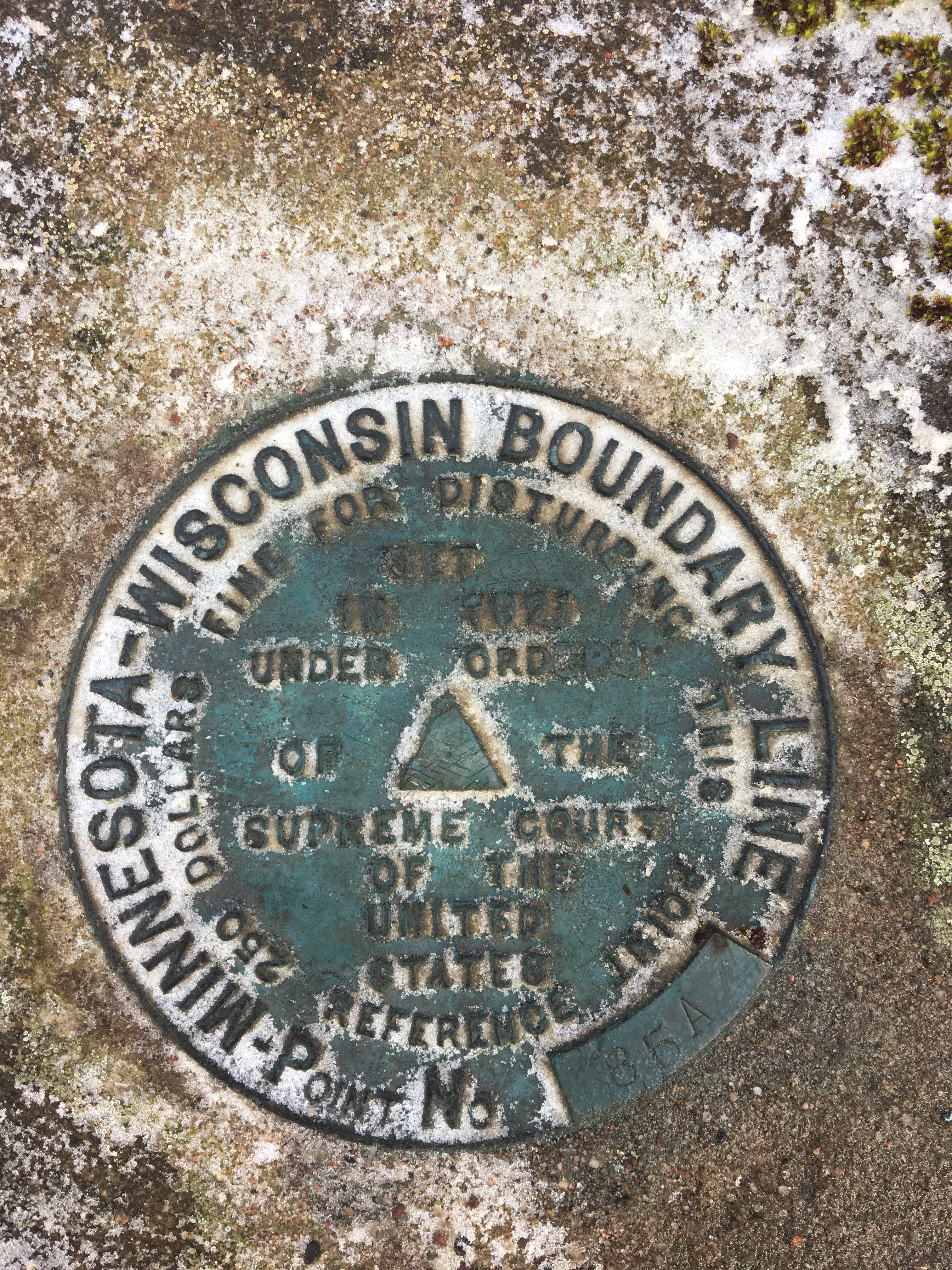
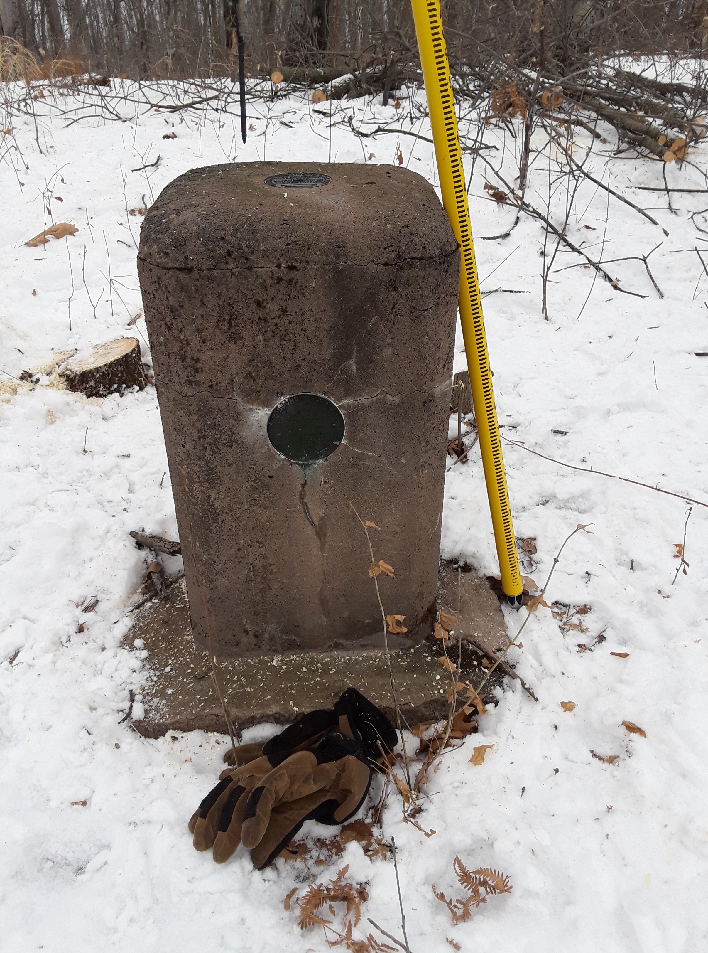
The predetermined angle points were measured with a Transit Theodolite with a 6 ½” circle accurate to ten seconds of arc. Furthermore a direct solar observation was taken at every angle point with the exception of the very shortest lines. The third component came after the snow melted and lasted late April to until June 15th. This component was to replace the original Corps of Engineers triangulation station Iron Pipe Monuments with more permanent metal reinforced concrete monuments. Each position, with the approval of the Corp of Engineers, was precisely removed and rebuilt. The new monument was a behemoth. The base measured four feet square at the bottom and two feet square at the top and was four feet deep. On top of the base is a rectangular prism of concrete 15 inches square by two feet tall. The top was rounded and the bronze cap as previously removed was placed back on top. On the side of these monuments a new tablet was placed vertically and was stamped” Minnesota-Wisconsin Boundary Line” with a reference number. Along with the three commissioners there were three consulting engineers, a transit man, two chainman, three rodmen and two draftsmen. The consulting engineers were Gordon F. Daggett of Madison, Wisconsin, Lyonel Ayres of Duluth, Minnesota and D. W. Van Vleck of Superior, Wisconsin. The transit man was Paul Lillard of Madison, Wisconsin.
A beautiful map was drawn showing all the angle points and monuments, but not the rectangular coordinates. They, along with many more details, are included in the final report. In the end the entire survey cost $15,626.06 and was paid equally by both States equating to $849.24 a mile over 18.4 miles. Printing costs were also equally split and amounted to $2,790. The original estimate for this survey was $25,000. The Supreme Court accepted and approved the report as submitted by Gannett on January 30, 1922, once again setting in stone and ink the position of another highly disputed State Line. I would like to thank Douglas County Surveyor Matt Johnson and Anthony Lueck for their assistance in research and local knowledge about this colorful State Line.