 Epson Debuts New T-Series Wireless Technical Printers
Epson today announced two new high-speed, easy-to-use wide-format SureColor® T-Series plotters the Epson SureColor T3170 24-inch desktop printer and the SureColor T5170 36-inch floor-standing printer. Marking Epson’s expansion of the T-Series product line to the low-to-mid-range CAD printer market, the new wireless printers feature an all-new clean and compact design coupled with the reliable printing performance inherent in Epson’s technical printer solutions. Whether printing blueprints, line drawings, signage, or classroom posters the SureColor T3170 and SureColor T5170 benefit professionals and workgroups across a range of segments including architecture, engineering, CAD, GIS, education, corporate, home and small office settings.
“The SureColor T3170 and T5170 are designed specifically for innovators– engineers, designers and architects–looking for a compact printer that is worthy of being displayed in their environment,” said Matt Kochanowski, product manager, professional imaging, Epson America, Inc. “Leveraging Epson’s latest technology to deliver class leading print performance, the new printers also feature a new footprint that enhances today’s workspaces and allows users to wirelessly produce accurate and vibrant prints from tablets and smartphones virtually anywhere.”
Leveraging Epson’s new PrecisionCore® MicroTFP® printhead technology and enhanced Nozzle Verification Technology to automatically detect and adjust nozzle condition, the new printers offer breakthrough print speeds producing accurate A1/D-size prints in 34 seconds, precise detail and commercial-grade reliability. Featuring Integrated wireless and Wi-Fi Direct® connectivity, architects and designers can seamlessly print from tablets and smartphones3 or use the new 4.3″ LCD color touchscreen with simple and intuitive menu control and navigation. Next-generation high-capacity UltraChrome® XD2 pigment inks deliver durable vibrant prints with brilliant color and crisp lines.
The SureColor T3170 (MSRP $995) and T5170 (MSRP $2,395) will be available in September 2018 and offer a standard Epson PreferredSM Limited Warranty. The Epson SureColor T-Series printers are designed to work exclusively with Epson UltraChrome XD2 ink.
For more information, visit www.proimaging.epson.com.
 Virtual Surveyor Streamlines Workflow with New Version of Drone Surveying Software
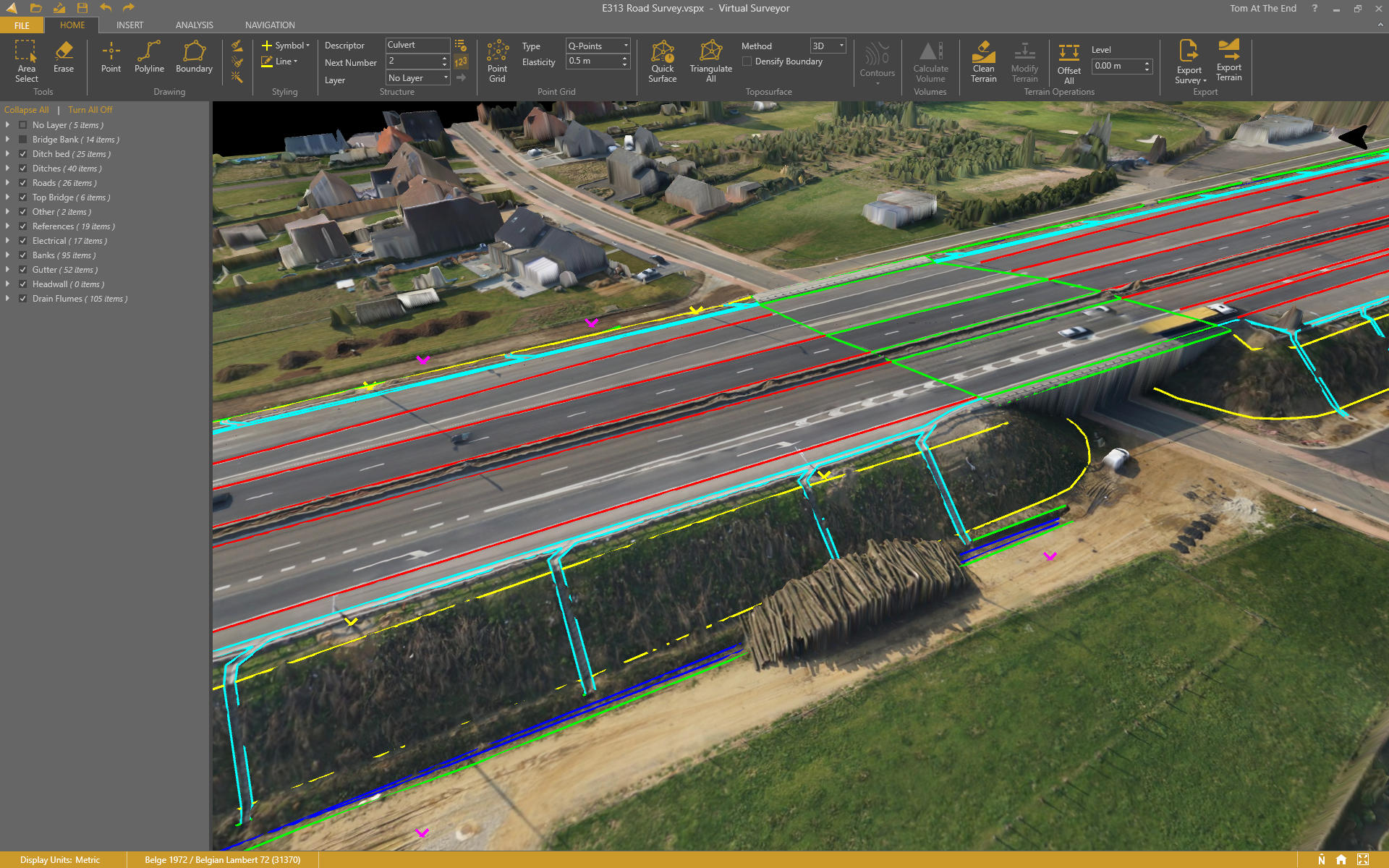
The Virtual Surveyor drone surveying software now offers a faster, more efficient workflow and better overall user experience in a more stable platform. These new capabilities, along with an improved licensing system and an extended free application, are available now in Virtual Surveyor 6.
“Surveyors who have used the Virtual Surveyor package in the past will be amazed at how easily they can manipulate data and how quickly the software renders results of even the most complex topographies,” said Tom Op `t Eyndt, Managing Director of Virtual Surveyor nv in Belgium.
The software leverages the expertise and interpretation skill of a land surveyor and combines it with the computing power of the computer. Virtual Surveyor generates an interactive onscreen environment through orthophotos and digital surface models, generated from the unmanned aerial vehicle (UAV), where the surveyor selects survey points and breaklines to define the topography.
Virtual Surveyor is extremely popular among land surveyors because it enables them to complement traditional fieldwork with UAV imagery to generate highly accurate topographic products up to five times faster than otherwise possible. Virtual Surveyor bridges the gap between UAV photogrammetric processing software and popular engineering computer-aided design (CAD) packages.
“The focus of Version 6 development has been to streamline the workflow–from the importing of drone data to exporting topo information into CAD–to make the surveyor more productive,” said Op `t Eyndt.
“The enhanced user experience will continue to appeal to professional land surveyors, who are our core client base,” said Op `t Eyndt. “And the seamless integration with CAD and advanced drawing tools will make Virtual Surveyor more attractive to design engineers.”
To start a free 14-day trial of Virtual Surveyor 6, visit www.virtual-surveyor.com.
SAM, LLC Announces Acquisition of Nobles Consulting Group, Inc.
SAM, LLC, a leading provider of geospatial solutions in North America, is pleased to announce it has completed the acquisition of Nobles Consulting Group, Inc. (NCG), a leading provider of professional services in the AEC industry across the Southeast.
SAM has been among the fastest-growing multidisciplinary professional services firms in the AEC industry. This investment enables SAM to continue aggressively expanding its services and geographic range within the Florida and Southeast markets.
NCG, based in Florida, has offices in Pensacola, Niceville, Chipley, and Tallahassee, joining SAM’s existing Orlando office for a total of five offices in the state. As of July 1, 2018, all employees of NCG became part of SAM and began operating in Florida as part of SAM Surveying and Mapping, LLC®. NCG Founder and President Allen Nobles and his existing management team will be joining SAM President and CEO, Chris Solomon and the SAM management team in leading SAM’s continued growth and expansion.
“We are very excited about the career and business opportunities this relationship brings for both the SAM and NCG teams,” said Mr. Solomon. “NCG’s reputation in the Southeast is second to none, and we are proud to partner with such a great organization that shares our own core values. We believe our future in the Southeast is limitless.”
Mr. Nobles noted, “We are excited to be able to promote our new partnership with SAM in the Southeast region. NCG has always been aware of the great reputation that SAM has, and this alliance should help take us to the next level. With SAM’s great staff, technology, and our common goals, this should be a great opportunity for both partners.”
Find out more at www.sam.biz.
NOAA Issues Final Report: Scoping the Value of the Regional Geodetic Advisor Program
The National Geodetic Survey (NGS) provides the foundation of the National Spatial Reference System (NSRS), making use of geodesy to develop and maintain reference standards and tools to utilize them. The National Academy of Sciences report on precise geodetic infrastructure defines the domain of geodesy as:
“The fundamental parameters of geodesy include the Earth’s shape (land and sea surface topography, bathymetry, and ice sheet thickness), rotation and orientation in space, and gravity field. These parameters all change with time as a consequence of the dynamic nature of the Earth’s system. Geophysical processes transform the Earth’s surface, modifying the distribution of mass within the Earth’s interior and its oceans, and consequently alter its gravity field and rotation.”
NGS provides access to its data, tools and training through extensive outreach efforts via documents, conferences and online capabilities as well as email and telephone support. The Regional Geodetic Advisor Program provides technical assistance and personal and group training to users of the National Spatial Reference System (NSRS) in their home regions to facilitate proper use of modern positioning technologies, NGS geodetic data and tools, and federal positioning standards. The program began in mid-2016 as a successor to the State Geodetic Advisor Program.
The objective of this socio-economic scoping study is to preliminarily assess the nature and benefits of the Regional Geodetic Advisor Program. Benefit information can be useful in improving understanding of customers, applications and requirements for program planning, informing decisions about the allocation of resources among programs, and for advancing recognition of the contributions of the program.
This effort has benefited from exceptional cooperation and assistance from NGS staff in providing information and from the insights of NGS staff and people interviewed.
The report can be found at https://geodesy.noaa.gov/PUBS_LIB/reg-geodetic-advisor-progsocio-economic-scopingstudy-6-1-18.pdf
May Construction Unemployment Rates Down Year Over Year in 45 States, Says ABC
Estimated May construction unemployment rates fell in 45 states on a year-over-year basis, rose in four states and were unchanged in one state (Alabama), according to an analysis of U.S. Bureau of Labor Statistics data released today by Associated Builders and Contractors.
The May 2018 not seasonally adjusted national construction unemployment rate fell 0.9 percent from May 2017 to 4.4 percent, the lowest May rate on record. At the same time, the construction industry employed 291,000 more workers nationally than in May 2017.
“May proved to be an excellent month for construction employment, despite the ongoing shortage of skilled construction workers,” said Bernard M. Markstein, Ph.D., president and chief economist of Markstein Advisors, who conducted the analysis for ABC. “In addition, contractors are contending with a rise in building materials prices and the likelihood of further increases due to proposed tariffs on many inputs into construction.”
Because these industry-specific rates are not seasonally adjusted, national and state-level unemployment rates are best evaluated on a year-over-year basis. The monthly movement of the rates still provides some information, although extra care must be used in drawing conclusions from these variations.
From the beginning of the data series in January 2000 through May 2017, the national NSA construction unemployment rate from April to May has declined every year but one (May 2009). The rate for May 2018 was down as well, decreasing 2.1 percent from April. Among the estimated state construction unemployment rates, all were down except for one, Wyoming, which was up 0.9 percent from April.
Visit ABC Construction Economics for the Construction Backlog Indicator, Construction Confidence Index and state unemployment reports, plus analysis of spending, employment, GDP and the Producer Price Index.
AEC Next & SPAR 3D Expo & Conference Draws Nearly 1,800
The 2018 edition of SPAR 3D Expo & Conference, co-located with AEC Next Technology Expo + Conference came to a close on June 7 in Anaheim, California having attracted nearly 1,800 professionals from 46 U.S. states and 40 countries, representing a wide range of industries including architecture, engineering, and construction; surveying and mapping; civil and transportation infrastructure, industrial facilities, plants, and asset management; power and utilities; manufacturing; law enforcement and forensics; historic preservation; archaeology and digital heritage; mining, aggregates, and stockpile management; entertainment and gaming; insurance and real estate; museums and cultural applications; research and academia; robotic and vehicle navigation and sensing; and many more.
SPAR 3D Expo and Conference joined forces with AEC Next Technology Expo + Conference to welcome thought leaders from around the globe in two distinct conference programs. Exhibits were integrated into one large exhibit hall allowing all attendees full access to all vendors. Networking events and multiple live-demonstrations areas including AR/VR interactive environments, a hologram vault, immersive environment dome, demo theater presentations, and more were also available to all attendees.
“We had an idea that the addition of AEC Next to SPAR 3D would be wellreceived but the reaction and event itself exceeded all expectations. The expanded exhibit floor and conference programming was a huge value-add for attendees and exhibitors. Attendance increased 55% over 2017 and historic SPAR customers were delighted with the number of new attendees and prospects including industry leading asset owners like Exxon Mobil, 3M, General Motors as well as industry tech giants Tesla, Google and Apple. The event has incredible momentum for future editions,” said Lisa Murray, Group Director for the conference organizing group Diversified Communications.
“Collaboration is an integral part of moving the building, design and construction industry forward and the speakers, attendees and exhibitors truly embraced that idea. It was great to see everyone come together from varied backgrounds in construction, facilities management, design, 3D processing, etc. and discuss best practices and needs without an air of competition. It was more about the common good that will propel the industry forward. I’m excited to see what comes next,” said Christine Salmon, Event Director for AEC Next.
2019 will bring AEC Next Technology Expo + Conference and SPAR 3D Expo & Conference together again from May 21-23, 2019 at the Anaheim Convention Center.
For more information visit SPAR3D.com
Woolpert Named a Top 20 Most Promising Google Solution Provider for 2018
Woolpert has been named one of the Top 20 Most Promising Google Solution Providers for 2018 by CIOReview magazine. The selection was based on reader nomination, a review of products and services, industry and market surveys, events and conferences, achievements and press.
Woolpert, Google’s largest geospatial partner, has decades of mapping and geospatial experience serving clients around the world. The firm has been a Google Maps partner since 2013 and has consistently doubled its Google Maps business year over year.
“We know Maps because we make maps,” said Jon Downey, Woolpert vice president and market director for Google Maps and Cloud. “We have more resources focused on mapping solutions, location analytics and geospatial science than our competitors in both the Google Maps and Google Cloud ecosystems, and we are a trusted adviser on everything that has to do with location. We’re proud to be able to provide our clients with these comprehensive services.”
CIOReview magazine, which analyzes information technology trends, included its list of Top 20 Most Promising Google Solution Providers in its Google Special edition released Tuesday. The edition includes interviews with Google CEO Sundar Pichai and New York Times Chief Technology Officer Nick Rockwell, and a handful of top provider spotlights, including Woolpert.
In the magazine, Downey discussed the firm’s roots serving the public sector in the geographic information systems (GIS) arena and how that has grown into enabling private sector clients to best leverage Google Maps and Cloud technologies within their applications.
“We’re not your average reseller; we’re adept at guiding clients through the entire process, from acquiring Maps credentials through implementation,” Downey said. “We are working right now to successfully transition our existing customers to the Google Cloud Platform, and open the door to the robust array of Google’s enterprise product line.”
Downey added that Woolpert, which earned the Google Cloud 2016 Fastest Growing Company Award for Maps, sees limitless opportunities for this partnership.
“We truly enjoy working with Google, the industry leader in maps and mapping content–not to mention the most powerful brand on the planet,” Downey said. “The money Google invests in its platform makes it easy to provide highly valuable and infinitely scalable services to our customers. We plan to continue to elevate our clients’ ability to leverage all that Google has to offer.”
For more information, visit woolpert.com or call 937-531-1258.
ABC’s Construction Confidence Index Surges in Q1
Despite ongoing concerns regarding labor force availability and rising interest rates, and emerging concerns regarding tariffs and construction materials prices, construction contractors emerged from the first quarter of 2018 with tremendous confidence, according to the Associated Builders and Contractors (ABC) Construction Confidence Index (CCI). Each of the three indices–sales, profit margins and staffing levels–increased during the first quarter and remain well above the threshold reading of 50.
• The CCI for sales expectations increased from 67.1 to 72.2 during the first quarter of 2018.
• The CCI for profit margin expectations increased from 60.7 to 63.4.
• The CCI for staffing levels rose from 65.1 to 70.2.
“For now, contractors remain in high demand and generally have significant pricing power relative to prior years,” said ABC Chief Economist Anirban Basu. “This should not come as a surprise. Backlog remains elevated by historic standards, both public and private construction spending continue to increase, and the economy has added jobs for a recordbreaking 92 consecutive months, triggering demand for many types of nonresidential construction, whether in the form of office buildings, hotels or data centers.
“That said, the CCI survey was conducted during the first quarter of 2018, when tariffs were being discussed more theoretically, and prior to a recent surge in materials prices,” Basu said. “More recent events suggest that a trade war among the United States and other trading partners, including China and Canada, is becoming more likely. Borrowing costs are also on the rise, with the Federal Reserve continuing to raise both the Fed Funds and discount rates. It is therefore conceivable that we have seen the peak in contractor confidence or that a peak is approaching.
“On the other hand, nearly 60 percent of surveyed firms expect profit margins to expand over the next two quarters, while less than 13 percent anticipate a decrease. Only 6 percent of surveyed contractors anticipate a decrease in sales volume, while nearly 80 percent expect an increase. This is especially remarkable given the inherent lumpiness in construction spending, with contractors often experiencing sharp decreases in construction spending volume as important projects draw to a close. The most recent survey results are consistent with the notion that the marketplace is so active presently that contractors, including subcontractors, are able to flow from project to project. Not coincidentally, just 4 percent of contractors anticipate decreasing staffing levels over the next six months.
The implication is that construction spending data should be quite solid during the next two or three quarters. Importantly, nonresidential construction spending downturns generally begin a year or more after broader economic performance begins to wane. While many economists warn of emerging storm clouds on the horizon in the form of rising inflationary pressures and greater asset price volatility, contractors and their peers can fully expect that 2018 will end up being a very fine year.
Visit ABC Construction Economics for the Construction Backlog Indicator, Construction Confidence Index and state unemployment reports, plus analysis of spending, employment, GDP and the Producer Price Index.
For more information visit abc.org.
![]() Dewberry Holds Fifth Boy Scout Survey Merit Badge Day
Dewberry Holds Fifth Boy Scout Survey Merit Badge Day
Dewberry’s Mount Laurel, New Jersey, office hosted its fourth annual survey merit badge day on June 3, 2018, for local members of the Boy Scouts of America. This is the fifth time employees across the company have organized the required exercises for the scouts to earn their survey merit badge.
The five scouts that participated in the 2018 session all earned their survey merit badges. The day included hands-on demonstrations, discussions about GPS and its importance and effects on surveying, and an overview of other relevant topics such as the application of technology, different types of surveying, and career opportunities within the surveying profession.
The requirements for the badge include a knowledge of first aid for the types of injuries that can occur while surveying, and proper identification of poisonous plants and animals that inhabit the area. The scouts must also find and mark the corners of a five-sided lot, measure the angles and distance between each corner, and compute the error of closure. With their field notes gathered, scouts must draw a plat of the survey to scale and write a metes and bounds description. They use a corner marker as a benchmark with an assumed elevation of 100 feet and a level and rod to determine the elevation of the other four corners.
With more than 100 badges currently in existence, the surveying badge is one of the original badges that still remains available for scouts to obtain, dating back to 1911. It is historically one of the most difficult to receive as merit badge counselors who are also professional land surveyors are in short supply.
To learn more, visit www.dewberry.com.
 The World’s Largest Reference Network
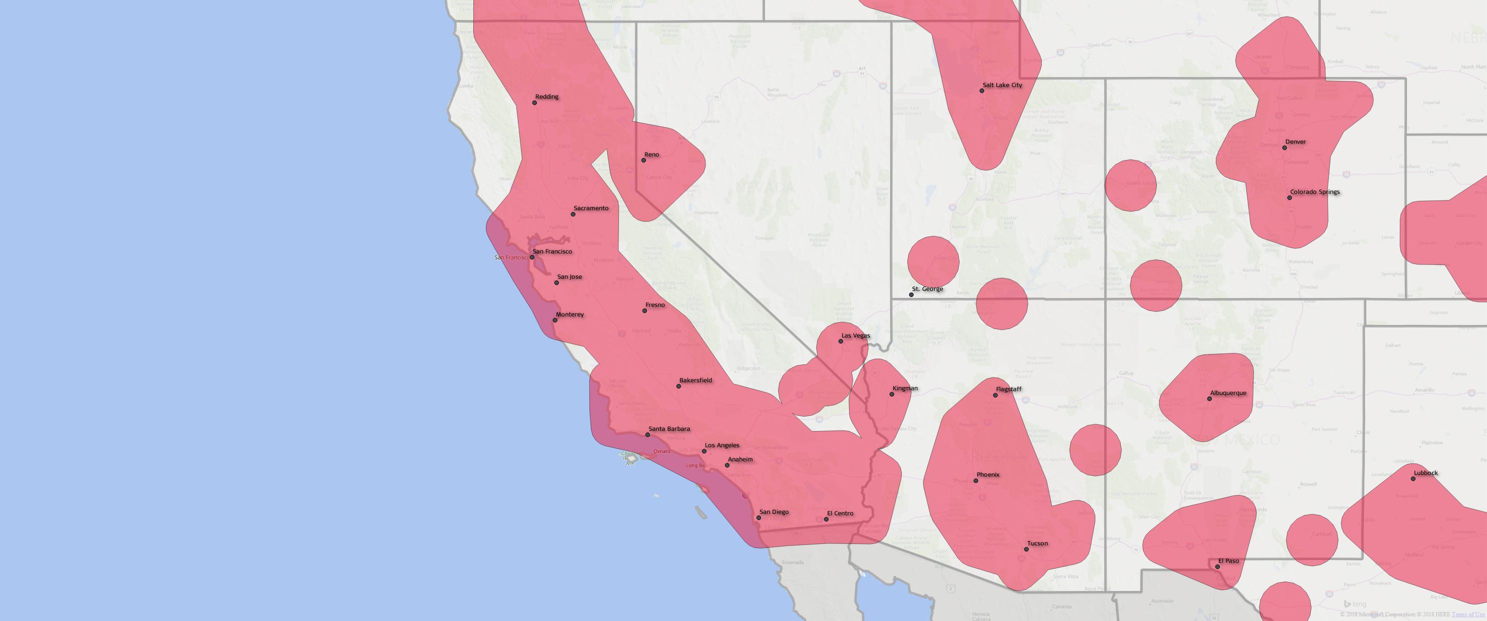
HxGN SmartNet is fully open to all makes and models of GNSS equipment and is designed to provide the highest reliability and accuracy 24/7. Launched in 2010, HxGN SmartNet was the first commercial GNSS network to allow for a single connection point for coverage across North America. Built on the most advanced GNSS reference station software platform in the world, Leica Geosystems GNSS Spider, HxGN SmartNet provides high-precision, high availability network RTK corrections for any application. A variety of different subscription plans are available at the state, regional and national level for any application requiring precision GNSS corrections. With more than 1,300 stations in 45 states and eight provinces, HxGN SmartNet North America offers the most extensive network coverage of any network service provider on the continent.
“GNSS users across all applications know they can rely on HxGN SmartNet to make the investments and partnerships needed to provide the easiest, fastest and most precise positions in the industry,” said Wendy Watson, director of operations for HxGN SmartNet North America. “AZGPS has a long track record of providing excellent service to GNSS users in the Southwest through the AZGPS and CALVRS networks. This cooperation between two familiar names in the positioning services industry underscores HxGN SmartNet’s commitment to `any constellation, any application and open to all.'”
For more information about HxGN SmartNet, visit https://hxgnsmartnet.com or follow HxGN SmartNet North America on Twitter at @smartnet_na. To learn more about AZGPS, visit https://www.azgps.net/.
 RDO Equipment Co. Promotes Adam Gilbertson to Vice President
Adam Gilbertson is Vice President of the Midwest Construction (West) region of RDO Equipment Co. and the Midwest region of RDO Integrated Controls. Effective immediately, Gilbertson, now based in Billings, MT, oversees the company’s five John Deere construction stores in Montana, as well as stores in Williston, ND, and Rapid City, SD. He’s also responsible to lead all efforts for RDO Integrated Controls in the region, including the company’s partnership with Topcon.
Gilbertson joined RDO Equipment Co. in 2003 as a Sales Professional and most recently held the role of General Manager of RDO Integrated Controls’ Midwest region. In addition to his industry experience, Gilbertson served the country for nine years in The United States Army as a Company Commander. In 2006, he spent several months in Iraq, leading a 168-person infantry in support of Operation Iraqi Freedom.
In his new role, Gilbertson is looking forward to continuing efforts to bring together the RDO Equipment Co. and RDO Integrated Controls total solutions approach for customers, saying, “John Deere is moving rapidly to integrate Topcon technology into its machines, and our customers have come to expect this combination of the best technology and the best equipment offerings. We can continue to deliver on both sides and offer our customers these opportunities to be more efficient and profitable in their work.”
Daryl Shelton, Executive Vice President at RDO Equipment Co. and RDO Integrated Controls, is pleased to have Gilbertson on the company leadership team, and believes Gilbertson’s experience and existing relationships are assets that will benefit team members and customers.
“Thanks to his years working with RDO Integrated Controls, Adam knows the market, customers, and team members extremely well,” Shelton said. “He has developed great relationships, both internally and externally, and I look forward to seeing him drive great results for all of our stakeholders.”
For more information, visit www.rdoic.com and www.rdoequipment.com.