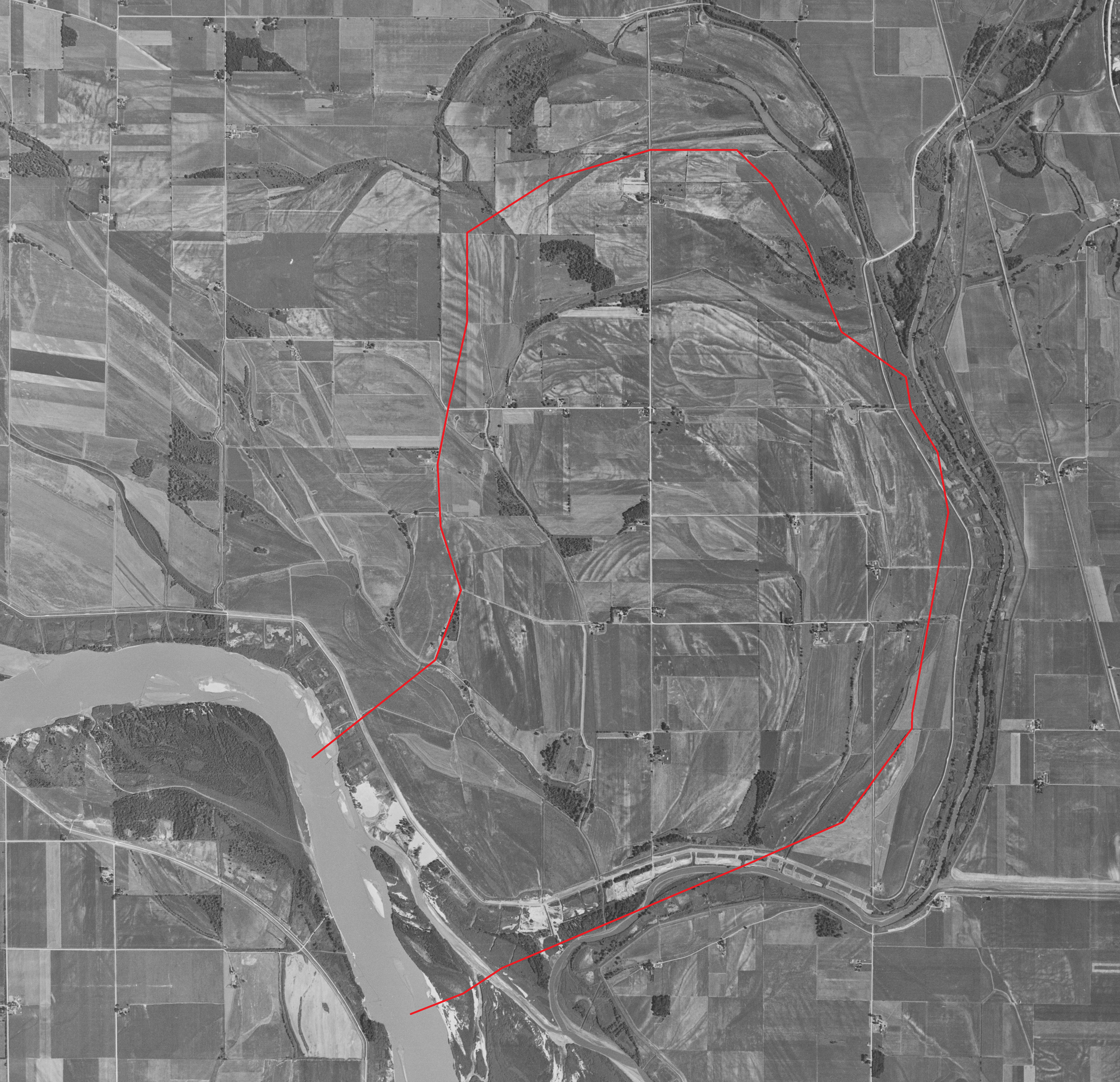
Located entirely east of the present-day Missouri River, a nearly 10-mile loop in the State of Missouri defines the legal location for land belonging to the State of Nebraska. USGS Photo 1953.
The Missouri River is the nation’s longest waterway at 2,341 miles. The width of this mighty river was historically less than one mile wide, but in some areas it indiscriminately meandered between high bluffs that were separated up to sixteen miles apart. The bed of this river could significantly change from one year to the next depending upon flooding. Five states share a common border with the Missouri River and before the river was confined to a defined channel, the interpretation of the state boundaries as first determined, were subject to confusion.
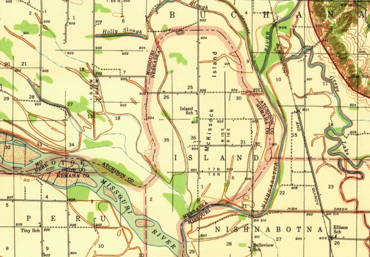
An area in the northwest corner of the State of Missouri where it shares its river border with Nebraska became an early location for dispute. The eastern bank of the river in this area was first defined in 1845 during the surveys of T66N-R42W of the 5th Principal Meridian. In 1856, during the surveys of the 6th Principal Meridian within the Territory of Nebraska, the river’s western bank was shown as being in T6N-R15E and T7N-R16E. At the time of both surveys, the river formed a ten-mile loop to the north and east that nearly closed back upon itself with one-half mile of land forming the neck. Nebraska had title to all the land within this loop. Although not completely surrounded by water, local residents often referred to the land within this loop as McKissick’s Island.
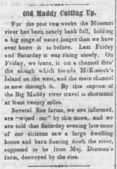
Nebraska Advertiser (Brownville, Nebraska) July 11, 1867
On July 5, 1867, the river decided that it had grown weary of following the loop and by avulsion cut a new channel across the neck. Nine days later, the steamer R. M. Bishop loaded with 3,000 sacks of corn became the first vessel to attempt passage up the new channel. Snags from fallen trees that had once been growing on the neck of the loop tore through the sides of the vessel and it sank within a few minutes. Two of the ship’s crew were unable to safely reach the shore and drowned.
After the avulsion, water continued to intermittently flow through the loop of the former channel until the new cutoff became more defined and the loop formed an oxbow lake. After each successive season of flooding, the lake filled in with sediment and eventually dried up. The former river bed became a shallow depression where the rich soil was ideal for tillable crops. The State of Missouri began assessing the land and taxing the landowners who lived within the loop stating the changed location of the river further west was now the boundary with Nebraska.
Since the Missouri River is the natural boundary between the surveys of both the 5th and 6th Principal Meridians in this area, there was no connection made by the GLO across the river between the states of Nebraska and Missouri. The meander lines, as determined at the time of the original surveys, only provided the location of the respective river banks on the date of the survey. The river, however, changed in several areas during the decade when the surveys were performed east and then west of the river. Even where the river did not significantly change, the true width of the channel remained unknown, so it was generally shown on the GLO plats as a pictorial estimate.
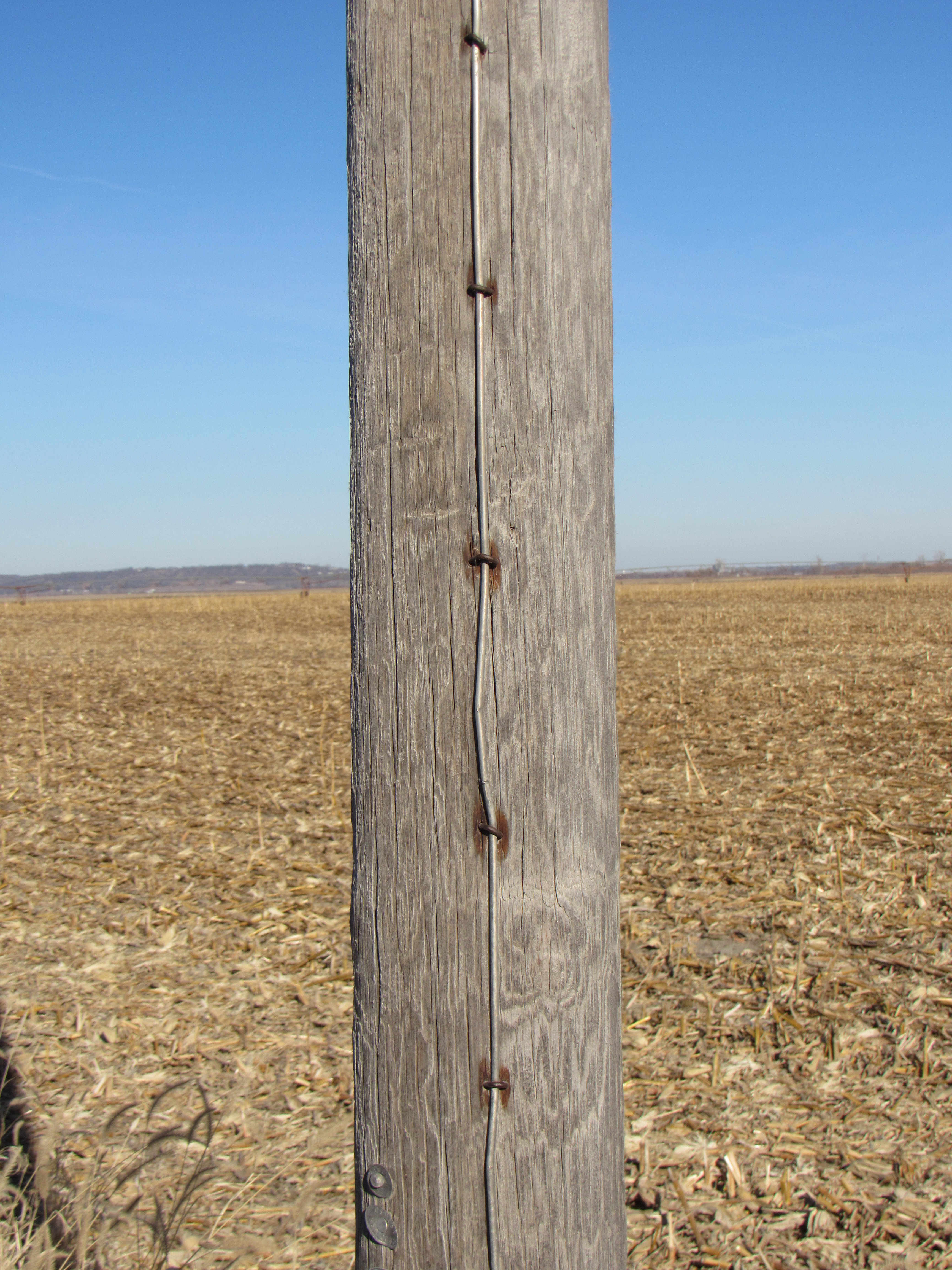
Rusted staples on a power pole show evidence of the 2011 flood (above). Today, there are no inhabited structures on McKissick’s Island. Those that remain are used for farm storage purposes (below). Courtesy Jerry Penry
One of the first court cases to be tried as a result of the changed course of the river was an accretion issue between two land owners on the Missouri side. In 1893, the Missouri Supreme Court case of Cooley v. Golden was brought by Millard F. Cooley, lessee of the Hamilton Land Company, against James F. Golden. For some years prior to the 1867 avulsion, land had been forming in the river channel on the northern end of the loop which had become locally known as Pole Island. This natural island contained tall cottonwood trees where the northern loop of the river had gradually moved south. The abrupt change in 1867 made it possible to combine the former the Pole Island area with the old channel. At issue was approximately 270 acres of unsurveyed land that involved the natural island and the old bed of the river.
In 1888, Golden purchased the area where Pole Island had once existed from a widow who had obtained squatters rights as early as 1861. Golden also claimed a large portion of the river bed and sought title from the government, but both the state and the federal authorities disclaimed any ownership to the former riverbed land. The Hamilton Land Company claimed ownership to the land on both sides of the old river channel and sought to eject Cooley from both the island and the former river bed stating that the entire riverbed had become theirs after the avulsion of 1867. The court found in favor of Cooley and established the principal that the soil underneath the water of navigable rivers belonged to the state and not to the riparian owner. This case, however, opened a larger issue as to which state actually owned over 4,300 acres within the loop after the avulsion of 1867.
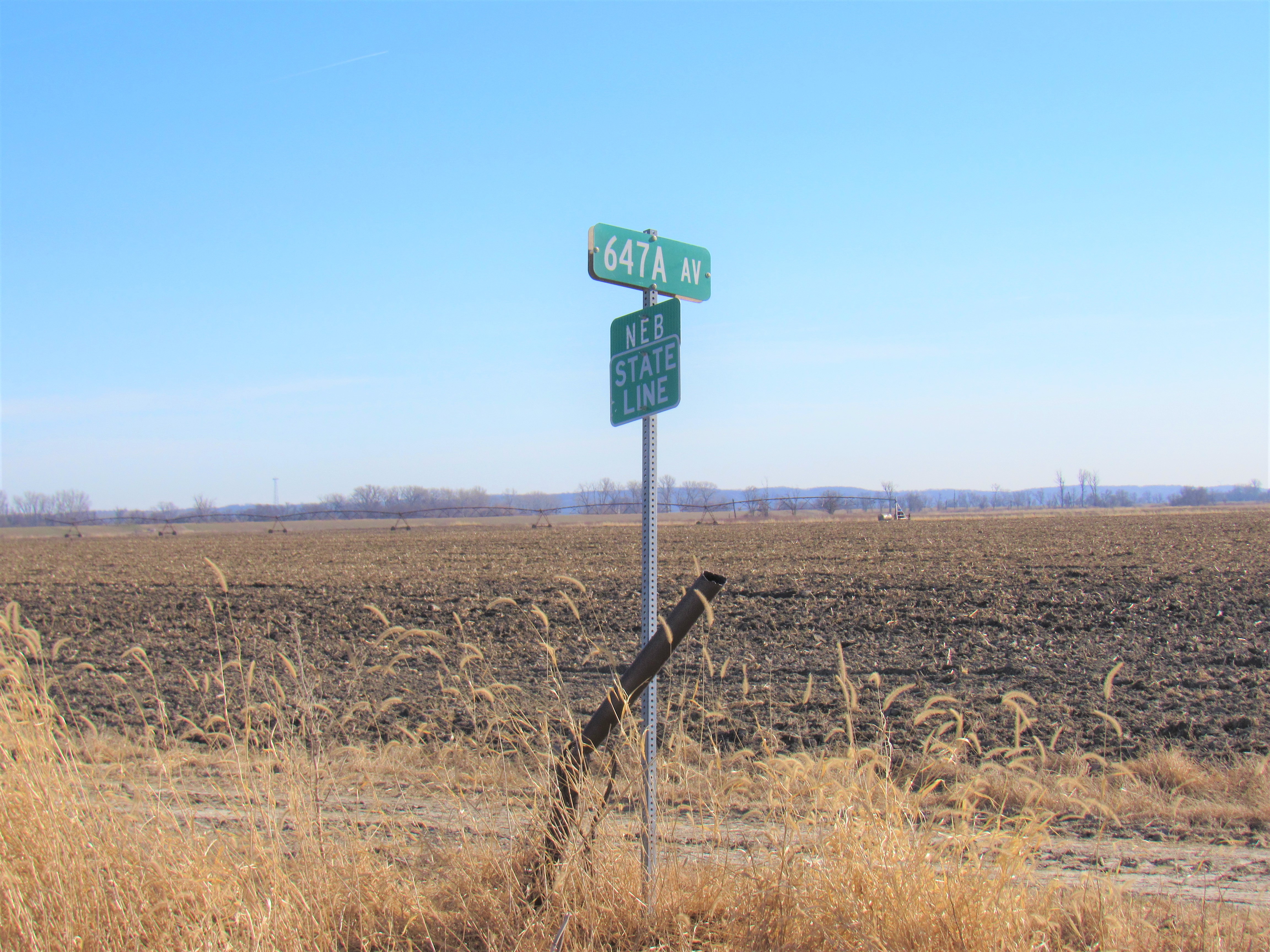
This state line boundary sign is located along a north-south road that bisects McKissick’s Island nearly 4.5 miles east of the Missouri River. Courtesy Jerry Penry
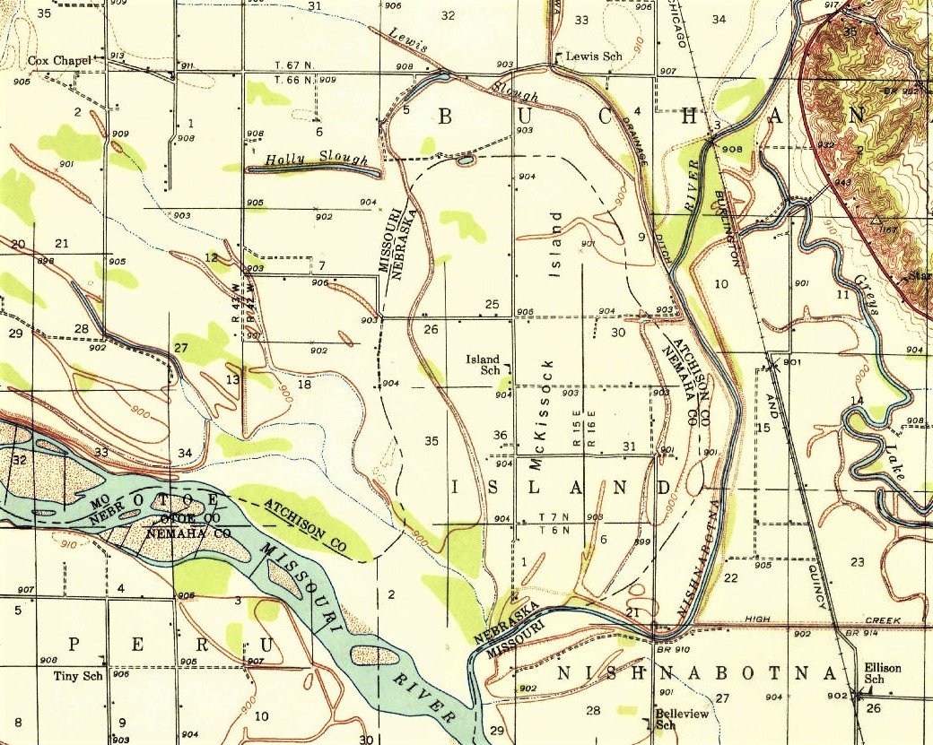
Knowing the McKissick’s Island situation would eventually need to be resolved, the county surveyors from Nemaha County, Nebraska, and Atchison County, Missouri, performed a series of surveys between 1890 and 1895. Their goal was to establish the center of the abandoned bed of the river by each coming from the original meander lines from their respective sides as determined by the GLO surveys of 1845 and 1856. From their survey, the center of the former channel was determined and became the first connection between the surveys of the 5th and 6th Principal Meridians. At each bend point on the calculated centerline, limestones with the letter “M” on one side and the letter “N” on the other side were placed by the county surveyors.
In 1904, Missouri v. Nebraska was heard in the United States Supreme Court to legally settle where the boundary between the two states should be located. The opinion of the court was that if the two states could agree upon the survey as previously determined by the county surveyors, that would become the legal boundary. The Missouri-Nebraska Boundary Commission was formed and the court ordered a new survey in 1905 to replace the limestones with concrete monuments 8-inch square and 5-feet tall. These new monuments were planted 4 feet into the ground and contained an angle iron embedded in the center that projected slightly above the surface. Plats were produced for each portion of the former river channel to show how the county surveyors had arrived at their determinations.
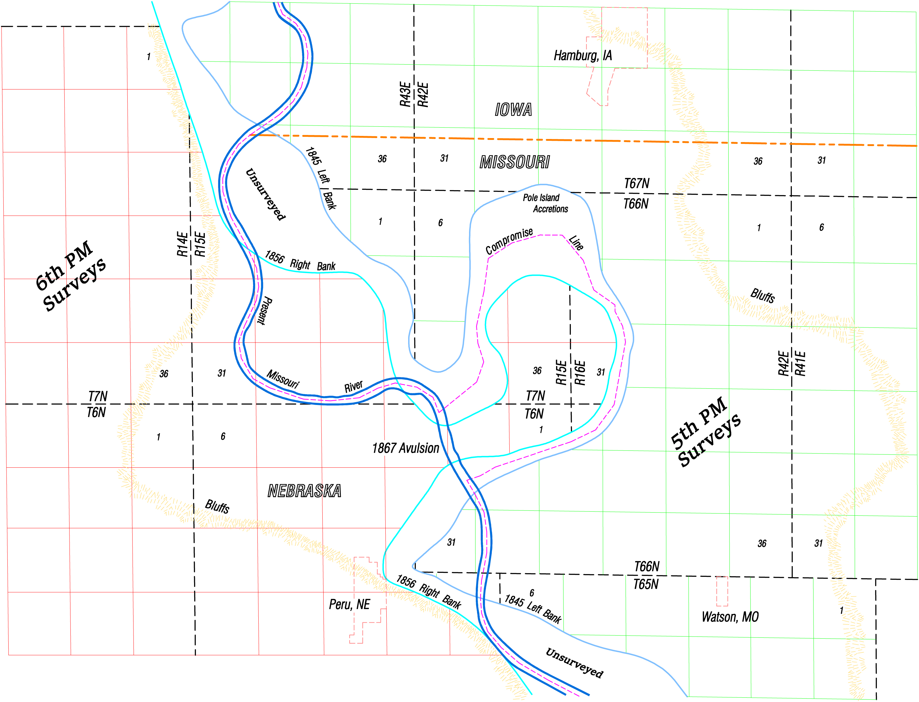
The sections outside of McKissick’s Island where the original river channel was located, was surveyed under the 5th PM surveys of 1845 (green lines). The sections inside the original river channel was surveyed under the 6th PM surveys of 1856 (red lines). Map by Jerry Penry.
Over the next five decades, the decision of the court could not resolve lingering resentment that continued to exist because isolated Nebraska land was on the Missouri side of the river. Other cases arose along the river with similar disputes where land had created itself on one side or the other by accretion or avulsion. To settle these matters, the Missouri-Nebraska Boundary Commission once again met in an attempt to determine where the entire length of the border between the two states should be located.
By 1958, the McKissick Island issue again found itself at the forefront of controversy. Property taxes were being paid to Nebraska, yet those living on the east side of the river largely benefitted from amenities provided by Missouri. The members of the commission for the State of Missouri argued that the center of the river channel that had been rechanneled by the U. S. Army Corps of Engineers should now become the legal boundary line between the two states. The 34 residents living on McKissick’s Island, however, all unanimously stated that they wished to remain Nebraskans.
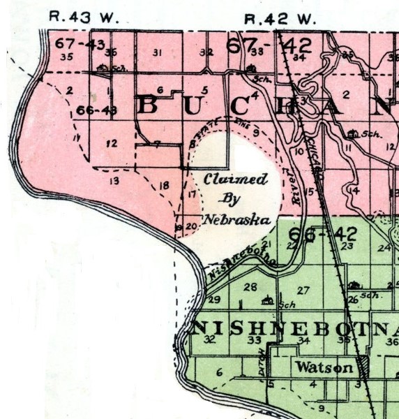
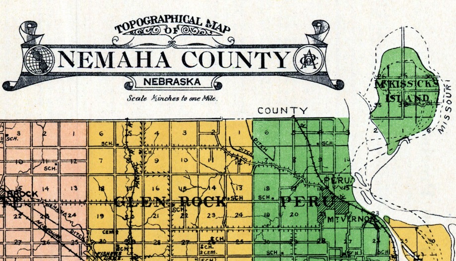
A 1921 map of Atchison County, Missouri shows the land claimed by Nebraska east of the Missouri River (left), while a 1922 map of Nemaha County, Nebraska shows the same area detached from the rest of the county (above). Courtesy Anderson Map Company.
For many years, a rural school named the “Island School” educated the youth living within the mathematical boundaries of McKissick’s Island. When the school closed, the Nebraska residents living east of the river began attending school in nearby Hamburg, Iowa. Residents of McKissick’s Island found themselves in an unusual situation where they held a Nebraska driver’s license with a Missouri address and were situated within an Iowa school district. In 1999, a retracement survey was performed to find and restore the boundary of McKissick’s Island. Many of the monuments from 1905 were found and those that were lost were restored.
 When the flood of 2011 inundated the entire area with up to 6 feet of water for several months, the remaining houses on McKissick’s Island were destroyed, thus ending any Nebraska residency upon the land. Today, there are 32 separate tracts recognized by Nemaha County, Nebraska, within the mathematical boundary of McKissick’s Island for which taxes are being paid. None of these tracts are owned by a person with a Nebraska address.
Click to enlarge all images.
1939 quad
1941 quad
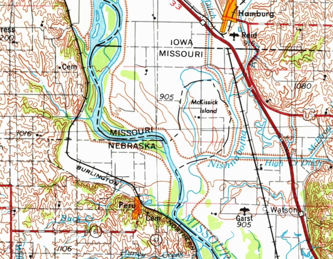
1955 quad