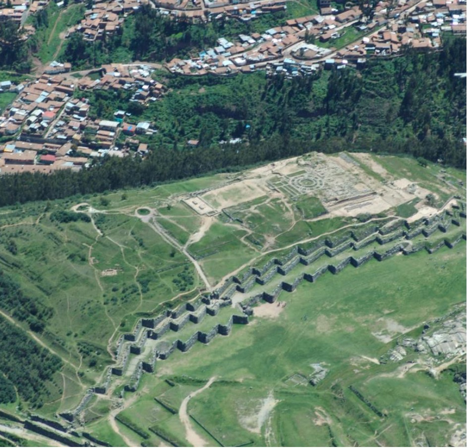
An aerial view of Saqsaywaman shows the zig-zag pattern of the three Great Walls. Plazas, towers and other structures occupied the top of the hill.
Sometimes, it’s best just to leave things as you found them. That’s the lesson shared by Dr. Richard Miksad and his students at the University of Virginia. As a result of studies covering nearly a decade, Miksad’s teams have developed detailed understanding about an often-overlooked component of South American history–the Saqsaywaman ruins near Cusco in Peru. In the process, they revealed that the engineering skills possessed by the ancient Inca civilization are on par with many modern techniques.
Miksad credits his conclusion to the work of his students and colleagues. The teams used a blend of spatial technologies to accurately model the site. In the process, they came to understand how some attempts at preservation could actually degrade the Inca masterworks. It’s a story that extends over centuries.
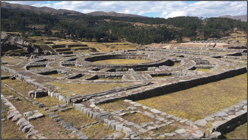
Ruins at Saqsaywaman reveal the myriad buildings, towers and plazas that once occupied the hilltop. The area is now protected as a World Heritage Site.
The Puzzle at Saqsaywaman
In the 15th and early 16th centuries the Inca Empire extended over much of western South America. In spite of the lack of metal tools and wheeled vehicles, Inca engineering and construction produced extensive, durable infrastructure. Their achievements include a vast network of roads, cities, ceremonial sites and agricultural areas.
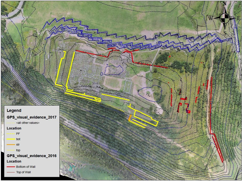
Students combined the Saqsayman data into a single 3D model for visualization and analysis. They could determine location of original structures and terrace walls.
One of the most important Inca sites was Saqsaywaman, a complex of buildings, towers and plazas built atop a hill adjacent to the Incan capitol city of Cusco. Researchers believe that Saqsaywaman was home for religious ceremonies and may have served as a temple of the sun–the Inca patron deity. Covering roughly 10 ha (25 ac), the site held stores of precious metals and gems as well as weapons and fine clothing. Archaeologists believe that construction involved thousands of people over decades of work.
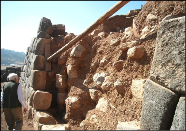
Collapse of a section of the Third Great Wall caused by uncontrolled runoff from an excavation above the wall.
When the Spanish conquistadores arrived in Peru in the early 16th century, they used their iron weapons and aggressive tactics to overwhelm the Inca. Almost immediately, they began to dismantle the Incan civilization. Inca leaders were removed and treasure was pillaged and stolen. In Cusco the conquered Inca were forced to demolish the structures of Saqsaywaman. Much of the stone was taken down to the city, where it was used to build government buildings and religious structures for the Spanish invaders.
“The Spanish obliterated Saqsaywaman,” explains Miksad. “They wanted to wipe away all vestiges of the Inca culture so that no one knew what was once there. For 400 years it was a rubble pile used as a quarry for the construction of colonial Cusco. Local government sold cheap permits that entitled–even encouraged–people to haul stone from the site.” The site is protected now, but stone from Saqsaywaman is evident throughout the city.
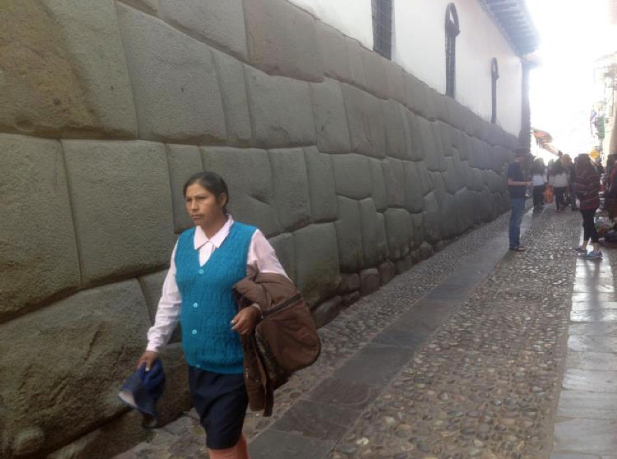
A street scene in Cusco features stone taken from Saqsaywaman. Residents were permitted to haul the stone for use in construction in the city.
Even in ruin, Saqsaywaman provides abundant examples of Inca expertise in construction. Massive stones weighing as much as 200 tons were cut and positioned using available tools and labor. Placed without mortar, the stones fit together so tightly that even today a sharp knife can’t be inserted into the joints. In 1983 the city of Cusco, including Saqsaywaman, was added to the UNESCO World Heritage List. Today Saqsaywaman is a tourist attraction and research site.
While only foundations of the Saqsaywaman buildings remain, the site remains rich with evidence of Inca ingenuity. Among its most impressive structures are three large stone walls up to 6m (20 ft) high that extend roughly 360m (1,200 ft) along the northern base of the hill. Known as the Great Walls, they form a series of terraces that stabilize the hill for the structures above. But after centuries of neglect and intentional damage throughout Saqsaywaman, the Great Walls are at risk of decay. That’s where Miksad comes in.
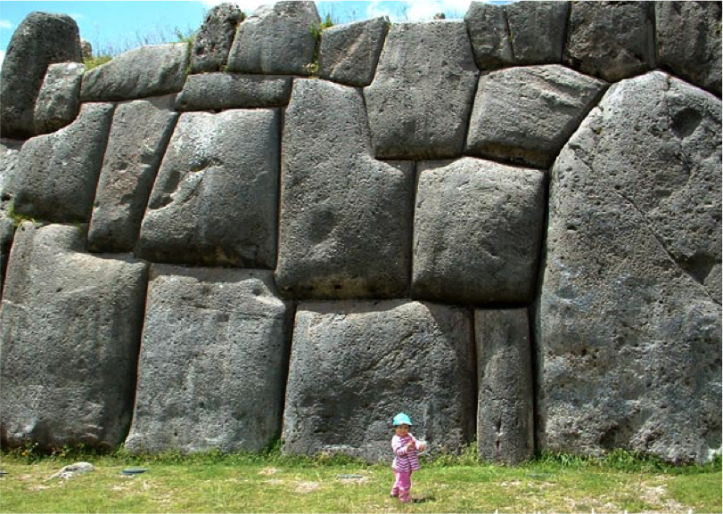
The massive stones of the Great Walls were cut and placed without mortar or iron tools.
A professor and dean emeritus of the Department of Civil and Environmental Engineering at UVA, Miksad conducts research into paleohydrology, including the study of the ancient human use of water in irrigation and urban supplies. He first visited Saqsaywaman 25 years ago and was thoroughly impressed by the Incan engineering. Since then, he has returned to Peru more than a dozen times. Working with Peruvian colleagues Dr. Jorge Hurtado and Dr. Leonardo Accostupa, Miksad has studied hydrology at Saqsaywaman, Machu Picchu, Ollantaytambo and other Inca sites.
For the past five years, Miksad has taken a group of civil engineering students to Cusco for weeks of on-site work. The teams collect information that they use to understand the role and effects of water on the land and structures at Saqsaywaman. In the summer of 2017, UVA civil engineering students Helena Nicholakos, Kyle Mavity and Zoe Schmitt accompanied Miksad to Cusco. They were joined by teams from Peru’s National Engineering University and Ricardo Palma University.
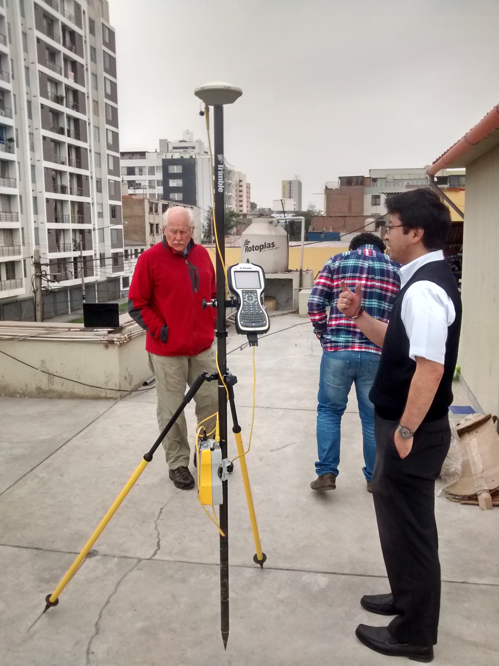
Prior to the field work, Miksad and the students received training on GNSS technology and practice.
A Measured Solution
Like any large development site, it’s important for Saqsaywaman to manage the water entering and crossing the area. Streams and storm runoff can quickly erode the land and place structures at risk. Many areas at Saqsaywaman are vulnerable to erosion from water, and human preservation efforts aren’t necessarily helping.
In a report on the project, Nicholakos, Mavity and Schmitt described the situation: “Centuries of damage combined with modern preservation practices have caused the Great Walls to begin to deteriorate. Much of the destruction is due to improper management of storm water on the site. Hydrologic damage now jeopardizes the structural security of the Great Walls. If this site is not soon amended with a more sustainable and technically sound preservation approach, the walls will continue to decay at an increasing rate. ”
Miksad cites an example in 2009 where archaeological teams excavated in an area above the uppermost Great Wall. Intending to protect the dig site, they covered it with a layer of clay. But the impervious clay allowed runoff to saturate the soil behind the wall. The resulting hydrostatic forces caused a section of the wall–which was not designed to hold or channel water–to eventually collapse. “It is this accidental destruction, (i.e. the unintended consequence of the good intentions of due to misinformed archaeological preservation), that we aim to amend and prevent in the future,” the students wrote.
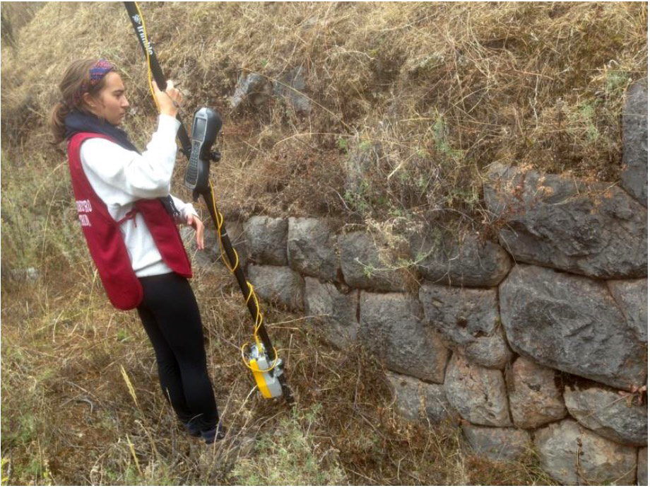
Helena Nicholakos uses a GNSS receiver to collect the location of a small terrace wall. The method produced required accuracy with fast, efficient field procedures.
A primary task in meeting the students’ objective is to develop an accurate map or model of the current situation. “We’ll use the model to analyze problems related to water runoff,” Miksad said. “From there, it’s possible to devise a plan to mitigate the issues.”
Building on knowledge gathered by predecessor teams, the 2017 group sought to understand Saqsaywaman as a comprehensive hydraulic system. To do so, they needed to have accurate data on the site topography and structures. Surveying technology including total stations and GNSS was used to capture the 3D location of visible features, including the Great Walls, building foundations and terraces. Because most of the Inca terrace ruins at Saqsaywaman are buried foundations and stones, the team combined GNSS with subsurface measurements using ground penetrating radar (GPR) and seismic refraction to map areas of interest.
The GPR and seismic refraction measurements relied on the GNSS system to accurately locate the measurement lines, which were then matched up with the surface GNSS measurements to give a consolidated map of the terraces. The work illustrates how GNSS, GPR, and seismic refraction measurement can work together–each providing different pieces of information which, when analyzed as complimenting sets of data, can create a full reconstruction model of the destroyed terracing system.
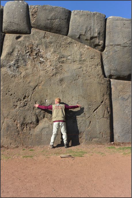
A researcher provides a sense of scale for the large, custom-cut stonework.
For the first three years, the Miksad-led teams had relied on a manually operated total station to capture the needed positioning data. In the course of their initial visits, they collected more than 8,000 points. But the work was slow, and the site’s terraces and rolling terrain required the team to traverse and move the instruments frequently. While essential to the team goals, the positioning work with the total station was taking valuable time from other investigations.
Seeking a faster method, Miksad in 2016 reached out to Isetek S.A., a Lima-based company serving the geospatial market in Peru. Isetek technical specialist Fernando Nakamoto provided a pair of Trimble R5 GNSS receivers, a Trimble TSC3 controller and Trimble Business Center software (TBC). Nakamoto spent three days training the students on GNSS field procedures and data processing.
A primary concern was gathering data with the high accuracy needed for the team’s modeling and analyses. “We explained the differences between RTK and post-processed kinematic (PPK) techniques,” Nakamoto said. “They decided to use PPK. It has the advantages of less equipment in the field and it is not necessary to worry about radio signal coverage. For them it was an easier operation that produced good results.”
Nicholakos said that the predecessor teams had produced much of the needed data. The 2017 GNSS fieldwork was devoted to capturing details on walls, terrace ruins and other visible features. They worked closely with the GPR and seismic teams, capturing GPR runs and the locations of seismic sources and geophones. All of the GNSS data was processed using TBC and the data from all sensors was ultimately delivered into GIS and civil engineering software. Thanks to a geodetic reference marker located on the site, the students could immediately connect the results to the Peruvian national grid. Their work fit nicely with field data from the previous summers.
All of the results were transferred to ArcGIS software for visualization and site analyses. Results from TBC were also sent to Civil3D software, which the team used to develop a digital 3D model for the entire site. “The assistance from Trimble made a world of difference,” Miksad said. “Using GNSS saved an immense amount of time and enabled us to take a professional approach to produce accurate, comprehensive mapping and 3D models.”
A Site for the Ages
Other Inca sites in Peru reveal how the Inca used terracing to manage drainage and runoff. Miksad believed that Saqsaywaman is no different, but centuries of destruction had obliterated the primeval terraces. It took three years and a combination of technologies to locate hidden walls and identify where original terraces were located. With that information now at hand, engineers can now make recommendations for preserving the site using the same techniques applied more than six centuries ago.
Not only did the Inca manage drainage and runoff, they incorporated water features throughout the Saqsaywaman site. In addition to terracing, the Inca engineered stone channels, fountains, drainage ports and other features to manage and supply water to the site. Working with archaeologists, the 2017 team investigated the source of water for Saqsaywaman, including remains of old canals and structures that carried water to the site from a stream north of Cusco.
The techniques used at Saqsaywaman and other sites nearby reveal the high level of Inca innovation and sustainable water use for practical and aesthetic purposes. As efforts to study and preserve Saqsaywaman move forward, engineers and archaeologists can collaborate using the knowledge revealed by the students’ studies. For example, archaeological excavations that might cause hydrological issues can be avoided; while engineering analyses of walls and foundations can help archaeologists understand the construction and purpose of the site’s structures.
Miksad believes that the best approach is to maintain and–as far as practical–restore the original terracing and water management installed by the Inca. “The Inca are the original green engineers,” he said. “They viewed water as a unifying force and built temples in its honor. We hope our work helps guard against unintentional changes or inaccurate restoration that might result in further damage.”
Erik Dahlberg is a writer specializing in the geomatics, civil engineering and construction industries. Drawing on extensive training and experience, Dahlberg focuses on applications and innovations in equipment, software and techniques.