What’s wrong with this picture?
Whew! We really beat the snot out of Bryant v. Blevins and practical locations. Well this month we’re back on new case that hit the Minnesota Supreme Court’s docket in 1982. We’ve got the familiar gymnastics of jurisprudence featuring an extraordinary array of flying rope stretchers on trapeze high.
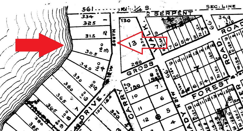
The numbers between the arrows were apparently present on the 1892 plat. The panel felt the plat was missing critical dimensions.
In a nutshell this turned out to be an estoppel case. The Supreme Court closed on this observation “The evidence clearly and unequivocally shows that there has been knowing silence on the part of Deerwood and unknowing detriment to Halversons. The Village of Deerwood is estopped from denying that the northern boundary of Lot Four has been determined by practical location”. By the way, a simple definition of estoppel is “the principle that precludes a person from asserting something contrary to what is implied by a previous action or statement of that person or by a previous pertinent judicial determination”…or if you are from my side of the Appalachians you can just round it off to “stop”. So that’s about as much lawyer lingo and gavel banging as we’re going to get into this month. Our concern in the case in how three surveyors can agree and be wrong? I am going full guns at these guys but I’ll be the first to admit that I may have done a similar thing at that time. These boys were breaking trail through fresh snow and the Supreme Court acknowledged their good faith attempt at resolving the boundary. Unfortunately an inconsistency with law reared its ugly head then negated the surveyor’s value toward the decision.
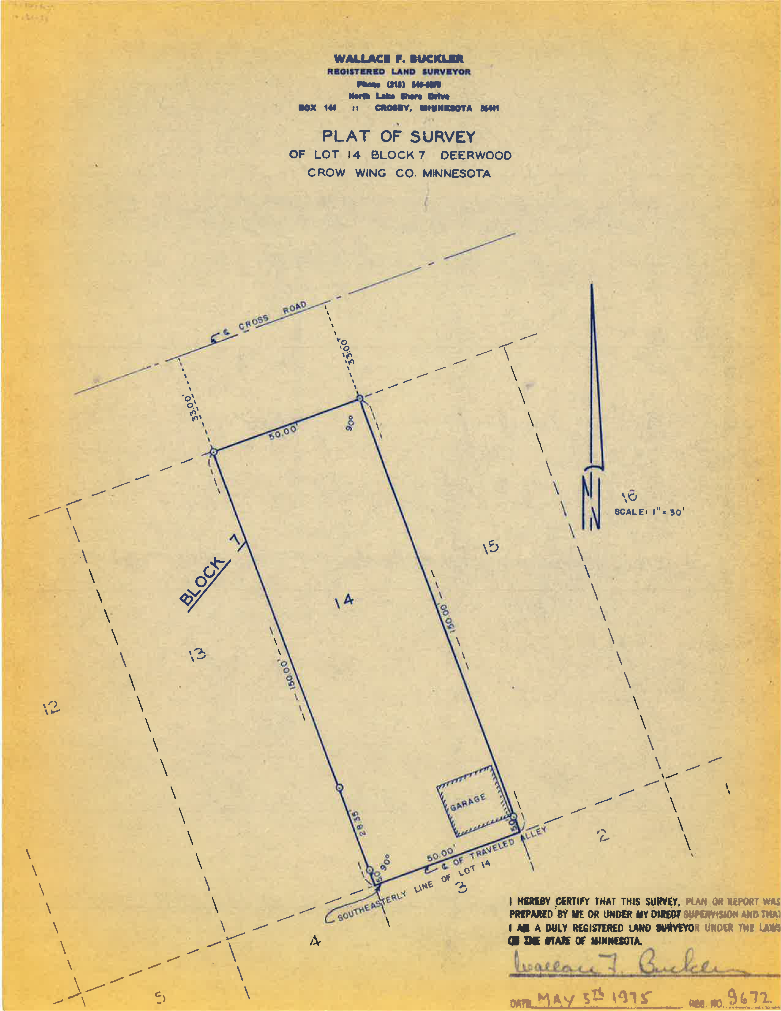
The other Wallace Buckler survey done in 1975 over in Block 7 just a few hundred feet away from our site.
So what went south? Well, let’s start with the surveyors’ charge. The parties (plaintiff & defendant) agreed to a stipulation settlement developed in a lower court. The settlement stipulated that “…a survey would be conducted according to the filed plat to determine boundaries…” Okay, easy enough, but according to the court this is what really happened. “A panel of registered land surveyors, selected pursuant to the stipulation, concluded that, because critical dimensions and directional lines were missing on the plat of 1892, it was impossible to describe the lots in question according to the filed plat. They provided instead a metes and bounds description of (the lands) as established by practical location”.
My jaw dropped when I read this. We have learned that the owners determine practical boundaries, the courts validate them and surveyors provide evidence to assist both. What part of this doesn’t fit? I see two things in hindsight that didn’t float in the land-o-lakes. Foremost the panel could have stopped at “impossible to layout” and asked for court direction. Pretty simple, right? That may have happened but the record doesn’t read so. When “impossible” is tossed around the courtroom it is an absolute term or at the least 99.99999999999% certain. An example might be if the map showed a total of only Lots 1 thru 10 and a deed called out Lot 11 of that map. That’s “impossible” in the plain and simple context. There never was a Lot 11 defined so it’s impossible to locate, right? Okay, back on pointe, a lack of geometric information on the plat does not negate the validity of the all of the other things that happened with the plat. Let me rephrase that. A lack of geometric information does not negate all of the other things that happened in accordance with the plat. These things include sales contracts, conveyances, mortgages, dedications, acceptance, and so on. As we have touched on before, platting is more than just the survey sketch. So let me put a perspective on this nonsense about “missing” dimensions. This line of baloney is the same as saying your car is a lemon because the kid who printed the window sticker didn’t use a comma in the price. Yes it’s that bad! The copy of the 1892 plat from Crow Wing County’s website does in fact show dimensions and descriptive language. It leaves a little to be desired but it doesn’t look broken beyond repair. Regardless, if it truly was impossible to identify the lots in accordance with the plat then how in the H-E-double hockey sticks did any conveyance happen at all? Are they all fraudulent? I bet not and I’m willing to wager that the panel was simply in over their heads.
This plat was surveyed and monumented. I know this because it say so right on the plat. It also says that the County Surveyor set stones at various places in accordance with this plat. Read the surveyor’s statement! This is evidence of the plat and a good starting place. We may have to retrace the whole subdivision to identify our lots and so be it. We are looking for every (or any) perpetuation of original evidence if the original marks are gone. There are section lines, roads, a railroad, and water features prominently displayed on the plat. How were these objects (read monuments) perpetuated? The panel claims there’s insufficient geometry to locate the corners but that did not stop any of the owners from purchasing the land in accordance with the plat nor the public from assuming the rights of way. This plat is incorporated into many deed descriptions, right? All that really can be surmised from lousy dimensions is that physical evidence on the ground becomes heavier on the scales of justice. So big deal if the plat data appears weak. The objective is to recover as much remaining evidence of the original positions as it takes to retrace the true boundary. This includes all of those things that happened in accordance with the plat!!!
Secondly there’s the panel’s whole metes and bounds thing. I am reluctant to speculate that the panel took it upon themselves to actually determine practical locations but that’s the way the court saw it. We’ve spent the last few months learning that a practical location has a basis in ambiguity recognized by uncertain owners. As we have discussed earlier in “Establishment of Boundary Lines by Practical Location” Loeb’s focus was “… rules which are applicable when the division line of contiguous lands as indicated by practical location does not correspond with the true boundary, as determined accurately by a survey based upon a call of deeds”. Okay, so what happens when a practical location actually does correspond with the true boundary? Well, you’ll have transparency and harmony between the true and practical boundary, right? Heck, if it’s that good you might not even realize the coincidence of the two legal principles braising right under your nose. Loeb also says “Ordinarily descriptions contained in title deeds will fix boundaries. The exceptional state exists when instruments of such dignity are disregarded, and the haphazard location of hedges, fences, ditches, and other physical objects are taken as the standard in their place.” The operative words are “disregarded” and “haphazard”. What evidence did the panel have of anyone actually disregarding the plat? As far as proving “haphazard” location, well, even a blind squirrel gets a nut sometimes and property owners are no different. They may have got it right. So, same question! What evidence did the panel have to conclude that the location was in fact haphazard? Please don’t say the plat drawing that was deemed impossible to retrace. Loeb’s concern relies on an accurate survey based on the deed calls to conflict with the practical location. Well guess what? It sounds like our panel threw the baby out with the bathwater. So how could a court expect anyone to prove that the occupation was not in accordance with the plat? Gnaw on that a while and see if it digests.
Where I get hung up is that the Court made it sound like the panel automatically assumed that the ground evidence absolutely could not represent a true boundary when plat geometry is just plain old fuzzy. Our old friend Chief Justice Cooley said this…”The general duty of a surveyor…is plain enough. He is not to assume that a monument is lost until after he has thoroughly sifted the evidence and found himself unable to trace it. Even then he should hesitate long before doing anything to the disturbance of settled possessions. Occupation, especially if long continued, often affords very satisfactory evidence of the original boundary when no other is attainable; and the surveyor should inquire when it originated, how, and why the lines were then located as they were, and whether a claim of title has always accompanied the possession, and give all the facts due force as evidence.” Did the panel do anything to substantiate the occupation as evidence of the true boundary or did they automatically jump to the conclusion that it was a unique practical location of the boundary simply because the 80 year old plat did not spoon feed them coordinate geometry? And another thing, how could this panel even identify the properties to write metes and bounds descriptions in the first place? I bet the owners could stand in the middle of their property with deed in hand and truthfully say “this is the middle of the lot described on my deed”. According to the panel, the plat was such a stinker that no one could disprove the owners anyway, right?
So here’s some food for thought. As we recover evidence shouldn’t our initial presumption favor the perpetuation of original evidence before we jump to a conclusion of practical location? If occupation melds with record descriptions there’s no need to “re-describe” anything. You have successfully retraced Lot X of Block Y and that’s the end of the story. Redefining a legal description may have the unintended consequence of disassociating it from its pedigree or worse yet may inadvertently invoke some unforeseen authority under law. I might be fooling myself but I really want to believe the panel mistakenly thought that they were simply helping the court understand the difference between measured and record by providing alternate descriptions. It’s plausible when you see us do similar things to identify conflicts outside of the courtroom. Obviously the court did not see it that way.
Let’s stop, drop, and roll here folks. It’s easy for me to highlight the dos and don’ts in hindsight, especially with the Court’s opinion in hand but don’t let that fool anybody. I am learning as much as you from this case and formulating my own perspectives from the experience bought and paid for at these guys’ expense. I also am not privy to all of the information but simply rely on the record and whatever I can churn up from the County’s website. I could not find the referenced Buckler Survey but found a similar one within this subdivision (see previous page for a survey performed in 1975). It’s a decent survey lying just a few hundred feet from Halverson. More importantly, Buckler appeared to have no trouble identifying these particular lots in accordance with the plat. I also found over thirty other surveys successfully retracing this subdivision in accordance with the plat both before and after the case was settled. I just don’t think the original plat was as humpty dumpty as the survey panel implied. I also want to point out that I’m narrowly examining the surveying principals in this case to provide general examples. You’ll notice that Buckler’s 1975 “Courtroom” survey apparently was made in accordance with the plat as both he and the Court called out encroachments on specific platted lots. Is there a chance of any of you Twins fans getting your hands on a copy and forwarding it to rls43185@gmail.com?
The Court evaluated the evidence and decided that Deerwood could not deny that the northerly boundary of Lot 4 had been determined by practical location. Had the panel of surveyors been able to make a connection to some evidence of the original plat perhaps the court may have arrived at some other conclusion. Nonetheless the court called the practical line the north line of Lot 4 rather than a new metes and bounds line. We previously touched on practical locations maintaining the dignity of the legal description. I also point out that the court took notice of the Halverson’s paying taxes on cabins that the Assessor incorrectly described on Halverson’s Lot 3. As I stated in Bryant v. Blevins the meat hooks of Tammany Hall should be considered when sorting out the evidence. I encourage everyone to make a good read of this case and take a look at Crow Wing County’s Website for additional survey maps.
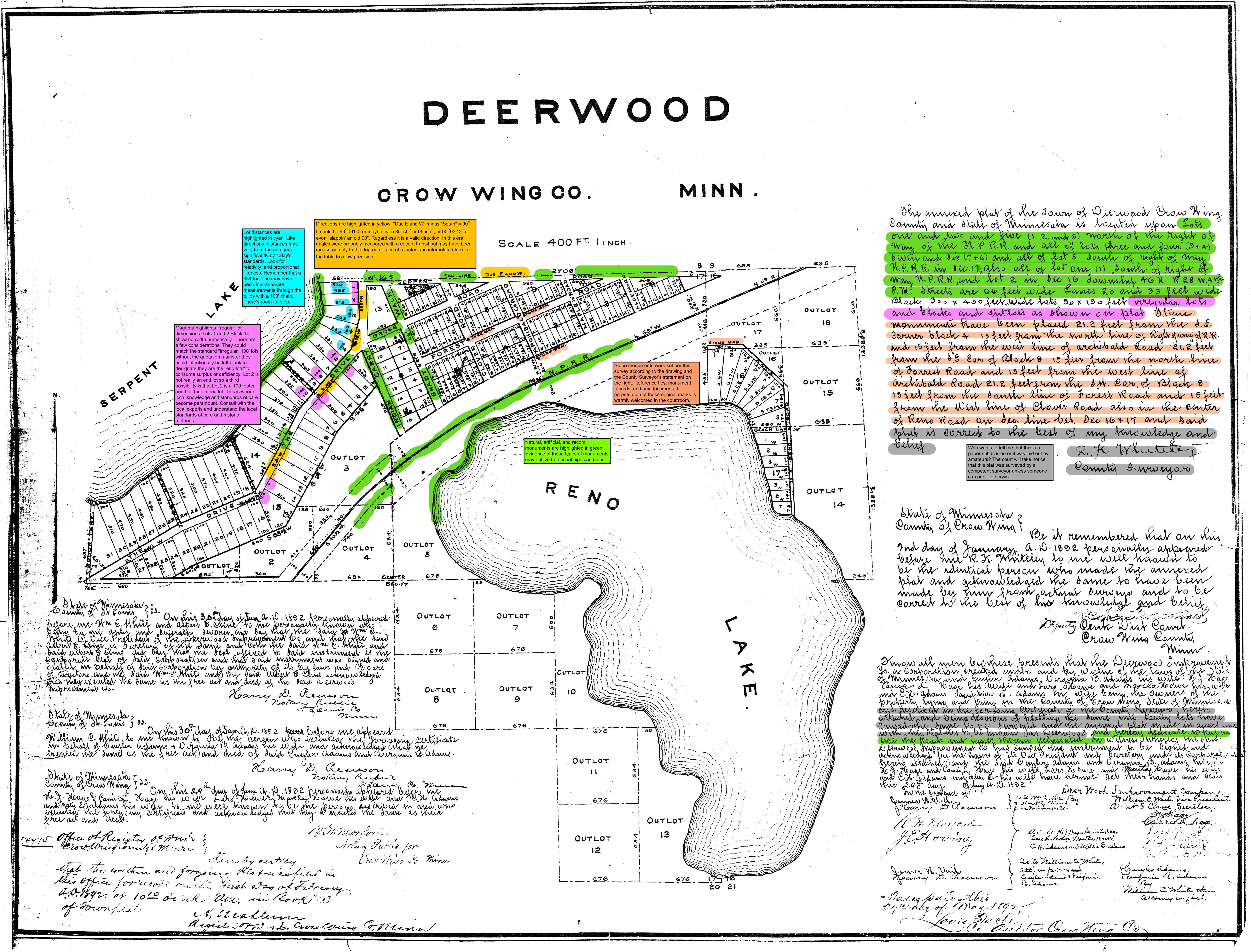
Note: A PDF of the full size original Deerwood plat can be found at https://amerisurv.com/PDF/Deerwood.pdf
 Sidebar:
The Barbershop Barrister
I thought this might be a good opportunity to get some learnin’ in the old barbershop. Let’s set aside the Halverson Case specifically and take a peek at the Deerwood Plat from 1892. I don’t have a lot of problem with this plat as drawn and can’t figure out why the panel did. Keep in mind that I don’t know what the field evidence looked like so there’s “that”. I have marked up the plat with some comments and observations to help sharpen your thought processes when approaching an old plat. Check it out at https://amerisurv.com/PDF/DeerwoodAnnotated.pdf and feel free to report back to rls43185@gmail.com.