GPS: The Original “Next Utility”
“GPS: A Guide to the Next Utility,” by Jeff Hurn, published by Trimble in 1989.
In the summer of 1978, I worked as a rodman/chainman for Boston Survey Consultant (now the BSC Group). My crew partnered with the engineering staff to conduct soil percolation tests for septic system design. At one point, our boss informed us he had just attended a meeting at our corporate office in Boston on the status of the GPS satellite constellation. Little was known about this technology as the first GPS satellite (NAVSTAR 1) had only been launched months earlier. He told us that within a few years you would be able to put a “magic black box” on the surface of the earth and obtain XYZ coordinates. As an 18-year-old kid, it was impossible for me to comprehend as we were in the process of locating the percolation test holes with a turn of the century K&E transit, a handheld magnifying glass to read the vernier, a Philly stadia rod for distance interpolation, and a machete for cutting line. As I reflect on this story, I realize how lucky I am to have witnessed all these measurement technology enhancements over the last four decades.
Entrepreneurs and innovators like Charlie Trimble, Javad Ashjaee and Dr. Benjamin Remondi (the father of GPS kinematic principals) capitalized on this technology. The cost for one GPS receiver when they hit the market in the late 1980s was about $100,000. Three GPS receivers, software and state-of-the-art computers were needed since most of the survey applications required GPS static survey methodology, creating a half million-dollar investment on equipment alone and resulting in only a handful of companies adopting this emerging technology. But those who did became pioneers and industry leaders.
Game Changer #1—Real Time Kinematic (RTK)
On December 8, 1993, GPS Initial Operational Capability (IOC) was announced by a joint venture between the Department of Defense and the Department of Transportation. On April 27, 1995, GPS Full Operational Capability (FOC) was announced by the U.S. Air Force Space Command. This event reassured both public and private stakeholders of the validity of GPS. Real Time Kinematic systems started “trickling” into the profession.
My employer at that time was Mangini and Associates in Pueblo, Colo. Having worked for the progressive thinking BSC Group, I was versed enough in GPS technology to talk company management into buying an RTK system. I felt like a spaceman with my backpack, Trimble 4000 GPS receiver, GPS antenna, whip radio antenna, extension poles, heavy camcorder batteries and cables. Early RTK receiver technology suffered from limitations. The most notable was range or distance from base station to rover. Most manufacturers RTK systems specified positioning performance as 1 cm + 1 ppm RMS HZ x 2 cm +2 ppm RMS VT. The parts per million (PPM) component plays an important role later in this article.
Game Changer #2—Real Time Networks (RTNs) and Virtual Reference Station (VRS) Technology
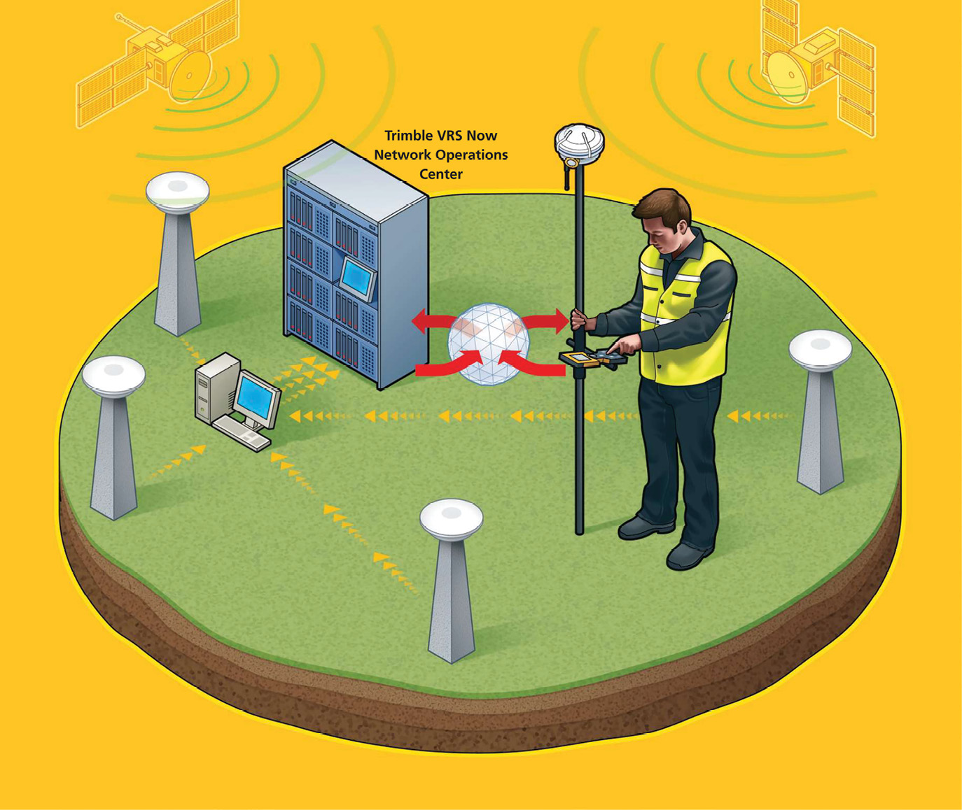
Illustration of RTN/VRS technology, a precursor to Trimble RTX.
Around the year 2000, my company was a sub-consultant on a Colorado DOT project in Grand Junction, Colo. The CDOT Project Manager told us that Mesa County had several UHF broadcasting base stations in the area. Having used RTK since its infancy, I understood the language he gave, but the workflow was foreign to me. All my RTK experience involved utilizing my base station and my rover. How was I to trust a third-party source of correction data? After observing multiple project control points with my RTK rover via corrections from one of the local Mesa County stations, I was sold! These local stations became the foundation for the Mesa County Real Time Virtual Reference Network (RTVRN)—one of the longest operational VRNs in the country. As robust as GNSS network solutions have become with enhancements of correction data via internet protocol, they all have limitations. For one, they cover a specific geographic location that is typically geo-fenced—whether that be city, county, states or larger. Another limitation to RTN solutions is cellular coverage, no cell = no data! Yes, RTK “bridge” technology exists that incorporates cellular boosters that rebroadcast the internet-based correction via UHF. However, this requires another piece of hardware, cables, and in most cases, a designated ISP data account.
Are Satellite Based Correction Services the “Next Utility” for the 21st Century?
 On several occasions during the mid to late 1990s I had the opportunity to collaborate with GIS professionals on creating survey grade GIS databases and schemas. The consultants utilized Trimble MGIS/resource-grade backpack mounted receivers and antennas with a handheld data collector. I was told that these units were OmniSTAR compliant and could receive satellite corrections from this fee structured Satellite-based Augmentation System (SBAS). Upon arrival, I would setup my RTK system and get to work. The GIS team, on the other hand, would assemble their system and then wait for almost an hour to receive OmniSTAR “convergence.” Meanwhile, I had already collected a fair amount of RTK data. When we compared observed coordinate values, at best, they were within a meter or so of my centimeter RTK value.
Now, fast forward to March of 2011 when Trimble Navigation acquired certain assets from OmniSTAR. This initiated a campaign of “disruptive innovation” not totally realized until May 5, 2020.
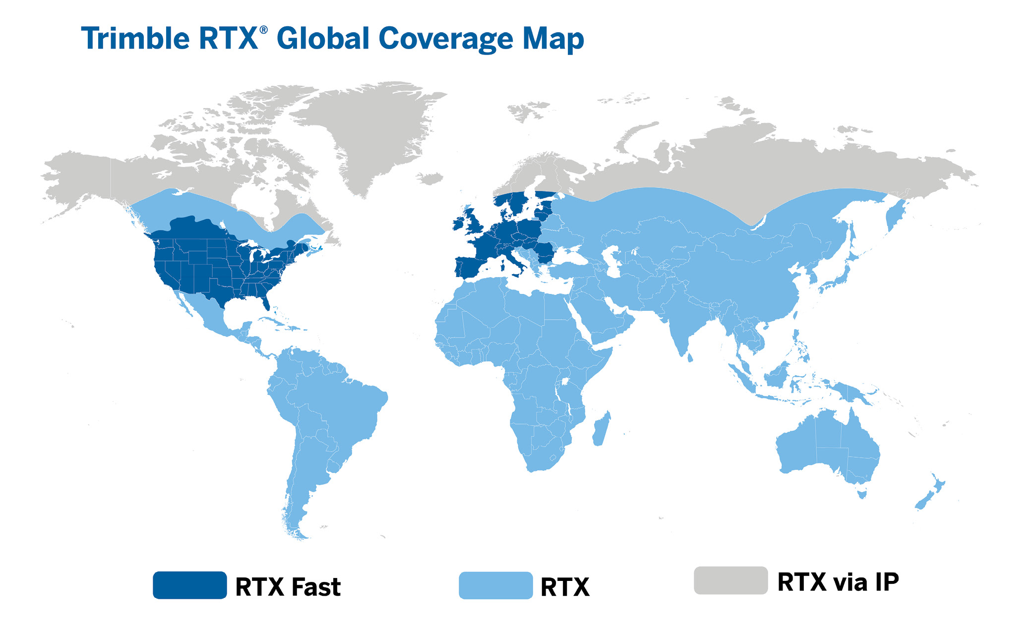
There exists a series of privately owned SBAS solutions from a variety of manufacturers (Novatel/TerraStar, EOS/Atlas, Trimble/RTX). Also, publicly available SBAS systems encompass the globe—WAAS (Wide Area Augmentation System), EGNOS (European Geostationary Navigation Overlay Service), GAGAN (GPS-aided GEO Augmented Navigation) and MSAS (MTSAT Satellite Augmentation System). Although beneficial, these publicly available SBAS solutions yield 1-2-meter accuracies at best. Trimble CenterPoint RTX (Real Time Extended) yields 2 cm (RMS) horizontal and 5cm (RMS) vertical accurate solutions in less than 1 minute. Automated transformations from global ITRF (2014) current values to NAD 83 (2011) are now performed real time in Trimble Access (TA) 2020. Additional enhancements are included in the December 2020 release of TA 2020.20. Most notably is the inclusion of plate motion deformation models. See: white paper “Deformation Models in Trimble Access 2020.20 and Trimble Business Center 5.40” at https://frontierprecision.com/wp-content/uploads/Trimble-Def-Models.pdf. In the U.S., (NAD83 2011) the Horizontal Time Dependent Positioning utility (HTDP v3.2.9) was incorporated. These new features resolve RTX to NAD83 (2011) legacy offset issues that required localization routines to remedy.
Briefly mentioned earlier in the article, on May 5, 2020, Trimble announced coast-to-coast coverage of CenterPoint RTX Fast service (less than 1 minute to convergence). All of this has happened since Q2 of 2020, which now makes RTX a “utility” that is much more than a game changer. Imagine being a large survey engineering firm with projects scattered around the U.S. or, for that matter, around the globe. All crews, regardless of location, could simultaneously work from the same correction source on the same geodetic datum with real time corrected data, all with the same accuracies! Mind blowing isn’t it? This is just the beginning of an avalanche of GNSS rendered enhancements I predict will happen over the next 5 years (or less)!
How does Trimble CenterPoint RTX work?
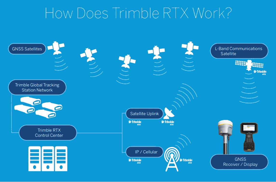 Trimble owns and operates a network of terrestrial tracking stations strategically placed around the globe. These stations receive data broadcast by all GNSS satellites (GPS, GLONASS, Galileo, BeiDou, QZSS) and are the basis for a precise global modeling campaign including GNSS satellite orbit, clock, and atmospheric errors. This data is then sent to the RTX control center and processed. The RTX control center transmits the processed data to two entities. One: IP/cellular. Two: the processed data is also up-linked to geostationary L-band satellites. The L-band satellite then broadcasts correction data to the end user in the field providing real-time cm level positioning without the need for a base station, UHF radio, VRS/RTN connection nor internet connectivity.
Over the past decade, as Trimble’s network of tracking stations has densified, convergence/initialization times have been reduced dramatically. On May 5, 2020, the densification of these ground-based GNSS tracking stations was sufficient for Trimble to release RTX Fast service for the U.S. and parts of Southern Canada. RTX Fast service boasts less than 1 minute to converge at 2 cm (RMS) HZ. With that said, I independently tested these specifications utilizing Trimble’s R10 Model 2 GNSS receiver and TSC7, Trimble Access and no cellular connection or local base. The result of using this technology in different environments, in different states and at varying times of the day was eye opening. Trimble CenterPoint RTX converged in less than a minute and met specifications. However, for even better results, I wait on average 5-7 minutes to obtain precisions of 0.03’/1cm HZ (DRMS) x 0.08’/2.5cm VT (1sigma). I chose these settings since DRMS (not RMS as in the specifications) has been the defaulted precision display in both legacy Trimble Survey Controller and Trimble Access for almost 25 years. Access 2020 gives users the option to select the job precision displays of legacy DRMS, 1 Sigma, 95% or 99% reporting. This enhancement integrates Trimble Access settings with those in Trimble Business Center as DRMS has been added to Trimble Business Center as well.
So, what’s in it for me?
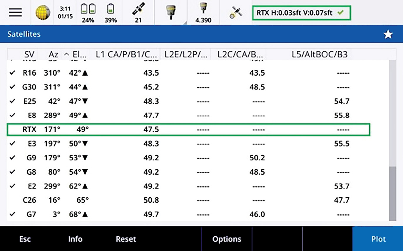
GNSS data collection displayed from all available constellations coupled with the RTX satellite. The top right corner displays the resulting RTX accuracies.
Trimble CenterPoint RTX yields centimeter accurate positioning. However, not all applications require these accuracies. Trimble RTX offers a complete portfolio of solutions based on accuracy specifications (to see the range of RTX performance levels offered, visit HERE). Regardless of the tier being used, all data collected from multiple disciplines would be rendered on the same global datum. For national, state, county and city entities, this could be huge. For the private sector surveyor, the benefits are significant considering the time saved not having to setup and breakdown a RTK base station, not counting the liability of leaving the station unattended. To validate the concept that a Trimble CenterPoint RTX solution will yield similar results to other legacy correction sources, I conducted a very basic test on one point. Prior to the December 2020 release of Trimble Access 2020.20, I utilized ITRF 2014 (2010) values in my testing. Since the recent incorporation of displacement models in Trimble Access (previously mentioned in this article), the test was conducted in NAD 83 (2011). Another point worth mentioning, as with RTK, RTX observed data renders not only HZ and VT precisions values but a full covariance matrix as well (QC2 in Trimble Access settings).
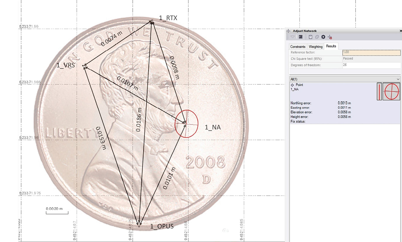
Multiple geodetic solutions calculated within the diameter of a penny.
The test data consists of 4 solutions as shown in the penny diagram in this article. Point “1_NA” was calculated through a least-squares network adjustment and tied to the national CORS network to create a “standard.” Point “1_RTX” is the result of a 180-epoch real time “observed control point” observation in Trimble Access with converged Trimble CenterPoint RTX. Point “1_VRS” was generated from the local Colorado-based Trimble VRS Now RTN. Point “1_OPUS” is the coordinate rendering via NGS’s OPUS RS Service incorporating a 1-hour data set. As shown, all is centimeter accurate (distances are horizontal in meters). Simply amazing, all falling within the diameter of a penny!
Another benefit to Trimble CenterPoint RTX as compared to traditional RTK—there is no compounding parts per million components. Depending on the specifications of the RTX receiver being used, my yearlong testing reveals that somewhere around the 3-mile mark (RTK base station to RTK rover) a threshold is met where RTX accuracies surpass that of traditional RTK. I do realize that Trimble VRS (Virtual Reference Station) solutions minimize ppm error by localizing a correction packet, but this is not the case with RTK. For long linear jobs (pipelines, powerlines, railroads) the benefit of this technology is substantial and worth investigating.
My preferred linear project workflow would be a least squares network adjusted “static” survey of primary control, then supplemented with RTK secondary control. Unfortunately, due to time constraints, budgets and other variables, many companies opt for an OPUS and/or RTK “traverse” survey. Both options are riddled with potential problems. I witnessed a situation where a surveyor was hired to survey around 70 miles of pipeline. He chose to “leapfrog” or traverse the line with RTK, continuously compiling both RTK and PPM error. Unfortunately for him, the pipeline had minimal design grade.
Trimble CenterPoint RTX solves most of these problems, bringing seamless accurate and repeatable geodetic control to all crews throughout the continental United States and Southern Canada. Naturally, if tight vertical control is required, a combination of RTX and RTK or differential level analysis could be incorporated as part of the project workflow and Standard Operating Procedures.
In closing, the title of this paper is a question: Are satellite-based correction services the “next utility” for surveyors and measurement professionals? After reading this article, I hope you will agree the answer is yes! This technology will continue to improve with enhancements to not only the geodesic sphere of GNSS, but also global terrestrial tracking networks, precise modeling of the atmosphere, and satellite clock and orbit algorithms. GNSS receiver and data collection hardware and firmware will continue to evolve, capture our imagination, increase productivity and so much more. Consider all your positioning solution options and remember “Measurement is a science, not the press of a button.” #HowYouMeasureMatters
Bob Green, PS, is a multi -generation land surveyor with more than 42 years of experience. For the past 17 years, he has provided sales, support and training for Trimble Navigation GNSS receivers, robotic total stations, 3D scanners, and lidar and survey software. Bob has been a positioning consultant to numerous government agencies including the U.S. Air Force Space Command, U.S. Marine Corps/Department of Defense, U.S. Border Patrol, Army Corps of Engineers, Homeland Security (FLETC) and NASA. Bob is employed by Frontier Precision and is a well-known public speaker and measurement technology advocate. Bob is currently working on several research and development endeavors to streamline and improve functionality to legacy geospatial workflows.